/maps/dir/locationA/locationB/locationC...
https://maps.googleapis.com/maps/api/directions/outputFormat?parameters
https://maps.googleapis.com/maps/api/directions/json?
origin=Chicago,IL&destination=Los+Angeles,CA
&waypoints=Joplin,MO|Oklahoma+City,OK
&key=YOUR_API_KEY
{
  "distance" : {"text":, "value":}
  "duration" : {"text":, "value":}
}{
"status": "OK",
"geocoded_waypoints" : [
{
"geocoder_status" : "OK",
"place_id" : "ChIJ7cv00DwsDogRAMDACa2m4K8",
"types" : [ "locality", "political" ]
},
{
"geocoder_status" : "OK",
"place_id" : "ChIJ69Pk6jdlyIcRDqM1KDY3Fpg",
"types" : [ "locality", "political" ]
},
{
"geocoder_status" : "OK",
"place_id" : "ChIJgdL4flSKrYcRnTpP0XQSojM",
"types" : [ "locality", "political" ]
},
{
"geocoder_status" : "OK",
"place_id" : "ChIJE9on3F3HwoAR9AhGJW_fL-I",
"types" : [ "locality", "political" ]
}
],
"routes": [ {
"summary": "I-40 W",
"legs": [ {
"steps": [ {
"travel_mode": "DRIVING",
"start_location": {
"lat": 41.8507300,
"lng": -87.6512600
},
"end_location": {
"lat": 41.8525800,
"lng": -87.6514100
},
"polyline": {
"points": "a~l~Fjk~uOwHJy@P"
},
"duration": {
"value": 19,
"text": "1 min"
},
"html_instructions": "Head \u003cb\u003enorth\u003c/b\u003e on \u003cb\u003eS
Morgan St\u003c/b\u003e toward \u003cb\u003eW Cermak Rd\u003c/b\u003e",
"distance": {
"value": 207,
"text": "0.1 mi"
}
},
...
... additional steps of this leg
...
... additional legs of this route
"duration": {
"value": 74384,
"text": "20 hours 40 mins"
},
"distance": {
"value": 2137146,
"text": "1,328 mi"
},
"start_location": {
"lat": 35.4675602,
"lng": -97.5164276
},
"end_location": {
"lat": 34.0522342,
"lng": -118.2436849
},
"start_address": "Oklahoma City, OK, USA",
"end_address": "Los Angeles, CA, USA"
} ],
"copyrights": "Map data ©2010 Google, Sanborn",
"overview_polyline": {
"points": "a~l~Fjk~uOnzh@vlbBtc~@tsE`vnApw{A`dw@~w\\|tNtqf@l{Yd_Fblh@rxo@b}@xxSfytA
blk@xxaBeJxlcBb~t@zbh@jc|Bx}C`rv@rw|@rlhA~dVzeo@vrSnc}Axf]fjz@xfFbw~@dz{A~d{A|zOxbrBbdUvpo@`
cFp~xBc`Hk@nurDznmFfwMbwz@bbl@lq~@loPpxq@bw_@v|{CbtY~jGqeMb{iF|n\\~mbDzeVh_Wr|Efc\\x`Ij{kE}mAb
~uF{cNd}xBjp]fulBiwJpgg@|kHntyArpb@bijCk_Kv~eGyqTj_|@`uV`k|DcsNdwxAott@r}q@_gc@nu`CnvHx`k@dse
@j|p@zpiAp|gEicy@`omFvaErfo@igQxnlApqGze~AsyRzrjAb__@ftyB}pIlo_BflmA~yQftNboWzoAlzp@mz`@|}_
@fda@jakEitAn{fB_a]lexClshBtmqAdmY_hLxiZd~XtaBndgC"
},
"warnings": [ ],
"waypoint_order": [ 0, 1 ],
"bounds": {
"southwest": {
"lat": 34.0523600,
"lng": -118.2435600
},
"northeast": {
"lat": 41.8781100,
"lng": -87.6297900
}
}
} ]
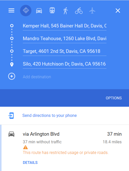
}locList = ['kemper+hall','mandro+teahouse', 'target', 'silo'];Start Point: Kemper Hall, 545 Bainer Hall Dr, Davis, CA 95616
Destination 1: Mandro Teahouse, 1260 Lake Blvd, Davis, CA 95616
Destination 2: Target, 4601 2nd St, Davis, CA 95618
Destination 3: Silo, 420 Hutchison Dr, Davis, CA 95616
Fastest Route: Arlington Blvd
Distance: 18.4 miles
Duration: 37 min
Directions API - Google Developers Direction Requests Format
