The CPS is for positioning artefacts on board the station, and not using GPS, as an global positioning system is unusable in context of liftoff from earth. It is a cylyndrical positioning system.
core is the true core and the only point where you can't go corewards.
core is defined as c0c0c0c0 or the REal core c0Re and the main-antenna marks its position.
when you're going towards the rim of the spacectation.
going against how you would write the letter C
going with the way one would write the letter C.
We have excavated 3 levels
Level 1 - c_huttle & tower
Level cero - mainhall
Level -1 - nerdarea and labs
Bold uppercase c in code style C
c is a good separator and will be used to separate all parts of the coordinates.
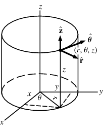
c{version, 3}c{(circular) angle}c{distance from core, radial distance r}c{level}
c\d+c{0.0-360.0}c\d+c(-)\d+
Example: c3c30c1140c0 (mainhall)
Right now we are in the 3rd reconstructions phase and therefore should use version c3 but still only have and use c2 maps. If we refer to location on the previous configurations, we change the version number accordingly.
There is a transformation matrix for transforming coordinates between versions.
Is a float number. c-base is at c30