Maintenance Mode As of May 1, 2016 no new functionality will be added to this project. For additional details refer to this issue.
If you need a fully integrated, robust offline solution that's officially supported, then please refer to our native ArcGIS Runtime SDKs for iOS, Android, .NET, Xamarin, Java, OSx and Qt.
Online samples are available here: http://esri.github.io/offline-editor-js/demo/
This project is also available on npm: https://www.npmjs.com/package/esri-offline-maps
This repo contains the following libraries in the /dist directory. The use of basic in the name indicates intermittent offline-only, and advanced indicates the library can be used for both intermittent and full offline.
Reference URLs are provided for developement only. It's recommended to use a CDN or host your own.
| Use_Case | Name, Description and gh-pages URL |
|---|---|
| Basic editing | offline-edit-basic-min.js Simple, lightweight (15k minimized) offline editing library that automatically caches adds, updates and deletes when the internet is temporarily interrupted.http://esri.github.io/offline-editor-js/dist/offline-edit-basic-min.js |
| Advanced editing | offline-edit-advanced-min.js Used for intermittent and full offline editing workflows. Also includes limited support for attachments. http://esri.github.io/offline-editor-js/dist/offline-edit-advanced-min.js |
| Basic map tiles | offline-tiles-basic-min.js Caches map tiles for simple, intermittent-only offline workflows. Use this library with ArcGIS Online Web maps as well as with tiled map services.http://esri.github.io/offline-editor-js/dist/offline-tiles-basic-min.js |
| Advanced map tiles | offline-tiles-advanced-min.js Used for intermittent and full offline tile caching. Extends any ArcGIS Tiled Map Service. This library should be used in conjunction with an HTML5 Application Cache Manifest coding pattern.http://esri.github.io/offline-editor-js/dist/offline-tiles-advanced-min.js |
| TPK files | offline-tpk-min.js Reads TPK files and displays and caches them as a tiled map layer. Works for both intermittent and full offline.http://esri.github.io/offline-editor-js/dist/offline-tpk-min.js |
src files are for software development-only. Themin versions are minified and should be used in production.
#Workflows Supported The following workflow is currently supported for both both features and tiles:
-
Load web application while online.
-
Once all tiles, features and attachments are loaded then programmatically take application offline.
-
Make edits while offline.
-
Return online when you want to resync edits.
This workflow is supported for intermittent offline and full offline. There are samples in the /samples directory for both use cases. For more information on the differences between intermittent and full offline check out this blog post.
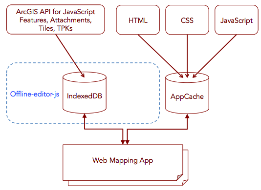
Full offline requires the use of an application manifest to allow for browser reloads and restarts while offline. The application manifest lets you store .html, .js, .css and image files locally. There is also a wiki doc to help you learn more about using the cache with this library.
Attachment Support: Attachments are supported with some limitations. See documentation here
#API and How To Use Docs
Go here to get links to the API docs and How to use docs.
Go here for answers to frequently asked questions.
##Setup Instructions
- Fork and clone the repo.
- After cloning from github,
cdinto theoffline-editor-jsfolder - Run
git submodule initandgit submodule update - Try out the apps in the
/samplesfolder. If they run, then everything is set up correctly.
##Build Instructions
- From the root directory run
npm install - Run
Grunt build. If there are no errors, the minimized (min) and source (src) versions of the libraries will be output to/dist - For production automation see the npm scripts listed in package.json.
##Limitations
- Currently does not support related tables, domains or subtypes. The ArcGIS Runtime SDKs fully support these and more.
- There are browser limitations and technical dependencies. The offline capabilities in this toolkit depend on certain JavaScript capabilities being present in the browser. Go here for a detailed breakdown.
- Attachments are supported with some limitations listed here.
- Browser storage space on mobile devices is a known limitation. This applies to stand-alone web applications and hybrid applications.
- The ArcGIS Editor Widget (ArcGIS API for JavaScript v3.x) may not work with
OfflineEditAdvancedafter a full offline restart. It's recommended that you build your own custom editing functionality that is fully mobile and offline compliant.
- Only the latest versions of Chrome, Firefox and Safari are supported.
- The most up to date information on this library's browser support can be found here.
##Dependencies
-
Offline.js - it allows detection of the online/offline condition and provides events to hook callbacks on when this condition changes
-
Node.js required for building the source
-
IndexedDBShim - polyfill to simulate indexedDB functionality in browsers/platforms where it is not supported notably older versions desktop Safari and iOS Safari.
-
Sub-modules (see
/vendordirectory)- jasmine.async - Used specifically for unit testing.
-
Non sub-module based libraries that are used internally by this project
- FileSaver.js - library to assist with uploading and downloading of files containing tile information.
- grunt-manifest node.js library to assist with the creation of manifest files.
- zip A library for zipping and unzipping files.
- xml2json A library for converting XML to JSON. Handles complex XML.
Find a bug or want to request a new feature? Please let us know by submitting an issue.
Anyone and everyone is welcome to contribute. Please see our guidelines for contributing.
Copyright 2016 Esri
Licensed under the Apache License, Version 2.0 (the "License"); you may not use this file except in compliance with the License. You may obtain a copy of the License at
http://www.apache.org/licenses/LICENSE-2.0
Unless required by applicable law or agreed to in writing, software distributed under the License is distributed on an "AS IS" BASIS, WITHOUT WARRANTIES OR CONDITIONS OF ANY KIND, either express or implied. See the License for the specific language governing permissions and limitations under the License.
A copy of the license is available in the repository's license.txt file.
[](Esri Tags: ArcGIS Web Mapping Editing FeatureServices Tiles Offline) [](Esri Language: JavaScript)
