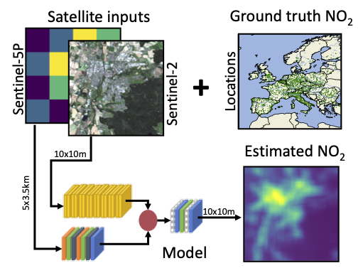
This repository provides the code for a paper on the estimation of surface-level NO2 concentrations from various data sources.
The local model (local_model directory) estimates surface NO2 for locations of EEA air quality ground stations based on station metadata with XGBoost.
There are two noteboooks for finding a good hyperparameter configuration and evaluation across multiple seeds, respectively.
This model (osm_model directory) is based on land cover statistics derived from the OpenStreetMap project and estimates NO2 with XGBoost.
There are two notebooks for finding a good hyperparameter configuration and evaluation across multiple seeds, respectively.
The satellite model (satellite_model directory) uses remote sensing data (Sentinel-2 and Sentinel-5P) to expand high-resolution NO2 estimation to a global scale.
The model is an artificial neural network with two input streams for the different data modalities, trained against ground-stations measurements in Europe.
The remote sensing data for training the network has to be downloaded separately from Zenodo.
To train the model yourself, download data from zenodo and store it in a data directory with subdirectories called sentinel-2 and sentinel-5p. These should then contain the one directory for each ground station with the corresponding files.
E.g.:
- eea
  - sentinel-2
     - GIB_Station_GB0050A
         - S2A_MSIL2A_20200715T110621_N0214_R137_T30STF_20200715T140105.npy
     - GIB_Station_GB0051A
         - S2A_MSIL2A_20200715T110621_N0214_R137_T30STF_20200715T140105.npy
     - ...
  - sentinel-5p
     - GIB_Station_GB0050A
         - l3_mean_europe_2018_2020_005dg.netcdf
     - GIB_Station_GB0051A
         - l3_mean_europe_2018_2020_005dg.netcdf
     - ...
Training can be started with with the satellite_model/training.py script. This script logs data to mlflow. Hyperparameters can be adjusted via command line arguments.
Example: To start training for 20 epochs with the remote sensing data located in /home/user/eea/, run the following from the satellite_model directory.
python training.py --epochs=20 --datadir=/home/user/eea
If you would like to cite our work, please use the following reference:
- L. Scheibenreif, M. Mommert and D. Borth, "Toward Global Estimation of Ground-Level NO2 Pollution With Deep Learning and Remote Sensing," in IEEE Transactions on Geoscience and Remote Sensing, vol. 60, pp. 1-14, 2022, Art no. 4705914, doi: 10.1109/TGRS.2022.3160827.
@article{scheibenreif2022toward,
  title={Toward global estimation of ground-level no 2 pollution with deep learning and remote sensing},
  author={Scheibenreif, Linus and Mommert, Michael and Borth, Damian},
  journal={IEEE Transactions on Geoscience and Remote Sensing},
  volume={60},
  pages={1--14},
  year={2022},
  publisher={IEEE}
}
