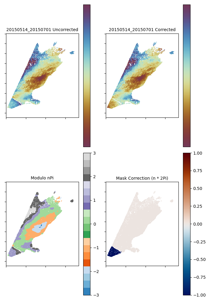
LOOPY is an open-source package in Python designed to identify and correct unwrapping errors in interferograms. It is written as an add-on to the COMET LiCSBAS software.
Having pre-processed their data in LiCSBAS, LOOPY can then be run on the unwrapped interferograms during the LiCSBAS processing chain
LOOPY consists of two steps - mask corrections (LOOPY01_find_errors.py) and linear inversion of loop phase closures (LOOPY03_correction_inversion.py).
To carry out mask correction, LiCSBAS02_ml_prep must have been run. LOOPY01 can be run on this multi-looked data, but for data directly downloaded from the COMET LiCSAR portal it is recommended to use the --fullres flag, as this will mean that errors are detected based on the full resolution tiffs found in the GEOC folder. It can be less effective on multi-looked data, where the sharpness of unwrapping error boundaries can be reduced, and therefore missed. For data processed using licsar2licsbas (ie cascade unwrapping), set the multilooking option in licsar2licsbas to 1, and avoid running the LiCSBAS step. This will produce a folder of GEOCml1[GACOS] on which LOOPY can be run - simply set the -m flag in LOOPY01 to the required multi-looking factor.
This step works by checking the difference between a pixel and all surrounding pixels - if this change is > 2pi radians, then this is flagged as an error boundary. Regions are flagged as errors if they are isolated from the reference pixel by an error boundary. In this case, we seek to correct this error by comparing the unw values on each side of the error, and trying to reduce it to < 2pi by applying a static offset to the error region. This is particularly effective for catching errors that are isolated from the reference region by full incoherent regions, or areas such as rivers that may have been masked out during unwrapping. If there are known areas that commonly feature an unwrapping error, then these can be ingested and included in the error mapping. Once this correction has been carried out, LiCSBAS may be run normally from step03 onwards as usual. If this step is to be run on the fullres data, then it must be run BEFORE the application of GACOS, masking or clipping (LiCSBAS03-5) or correction through inversion (LOOPY03). However, if you have already run up to LiCSBAS12 or 13 (up to loop-closure check or velocity inversion) then this step will seek out the detected ref.txt files in TS_GEOCml*. If you are working on already multilooked data (including GEOCml1), this script can be run after any optional GACOS, clipping and masking.
Linear Inversion of Loop Phase Closures looks to solve loop closures on a pixel by pixel basis, using a linear inversion with L1 Regularisation of the loop phase closures of a small-baseline network, as implemented by MintPy. Unlike LOOPY01, this can only be ran on multi-looked data, and can be carried out after LOOPY01, GACOS, masking and clipping.
Submit any issues in the issues tab
THIS IS RESEARCH CODE PROVIDED TO YOU "AS IS" WITH NO WARRANTIES OF CORRECTNESS. USE AT YOUR OWN RISK.
Morishita, Y., Lazecky, M., Wright, T.J., Weiss, J.R., Elliott, J.R. and Hooper, A., 2020. LiCSBAS: An open-source InSAR time series analysis package integrated with the LiCSAR automated Sentinel-1 InSAR processor. Remote Sensing, 12(3), p.424.
Yunjun, Z., Fattahi, H. and Amelung, F., 2019. Small baseline InSAR time series analysis: Unwrapping error correction and noise reduction. Computers & Geosciences, 133, p.104331.
The Scientific Colour Maps (Crameri, 2018) is used in LiCSBAS.
This work was created while completing a PhD at the University of Leeds, School of Earth and Environment, funded by the Natural and Environmental Research Council.
I thank Andrew Watson for advice with processing and coding, John Elliott for supervision, and the University of Leeds Active Tectonics Research group for feedback.
*Jack McGrath
COMET, School of Earth and Environment, University of Leeds


