getarc is an R wrapper for the ArcGIS Rest
API. It
provides access to any data hosted on an ArcGIS Feature or Map Server,
including exstensive open datasets (Arc
GIS). It currently only supports
functionality for querying data.
query_layergets data from an arc gis server and supports query operationsget_layer_detailsgets metadata about a layer such as the field names and maxRecordCountget_tokengets an access token via a web browser login to access private services
The package can currently be installed from github:
# Install the development version from GitHub:
install.packages("devtools")
devtools::install_github("matthewjwhittle/getarc")library(getarc)
library(sf)
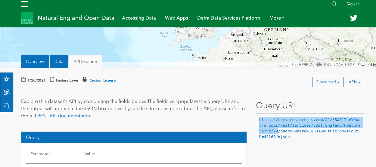
library(tidyverse)The query_layer function is used to query and download a layer from an
Arc GIS server. The layer is identified by the endpoint url. This can be
found by visting the service reference, clicking the API explorer tab
and copying the query url (up to “/query?…”).
A few endpoint urls are provided with the package for testing in the getarc::endpoints object.
national_parks <- query_layer(endpoint = endpoints$national_parks_england)
glimpse(national_parks)
## Rows: 10
## Columns: 10
## $ OBJECTID <int> 1, 2, 3, 4, 5, 6, 7, 8, 9, 10
## $ CODE <int> 10, 3, 9, 8, 2, 7, 5, 6, 4, 1
## $ NAME <chr> "SOUTH DOWNS", "EXMOOR", "YORKSHIRE DALES", "PEAK DISTR…
## $ MEASURE <dbl> 1653, 693, 2185, 1438, 956, 1441, 567, 1051, 2362, 302
## $ DESIG_DATE <dttm> 2009-11-02 00:00:00, 1954-10-01 01:00:00, 2016-08-01 0…
## $ HOTLINK <chr> "http://southdowns.gov.uk/", "http://www.exmoor-nationa…
## $ STATUS <chr> "Designated", "Designated", "Designated", "Designated",…
## $ Shape__Area <dbl> 1652679314, 693121787, 2184826675, 1437831813, 95574746…
## $ Shape__Length <dbl> 602554.5, 168905.7, 321727.5, 334994.8, 164533.6, 30456…
## $ geometry <POLYGON [°]> POLYGON ((-0.7978181 50.865..., POLYGON ((-3.89…
Spatial data is returned as an sf object. It is also possible to query tables on an ArcGIS server or return data without a geometry and this will return a tibble.
# Plot the first geometry in the object and add the national park's name as the title
plot(national_parks$geometry[1], main = national_parks$NAME[1])The ArcGIS Rest API supports a number of query operations to return only
the features you need. All query operations are supported via
query_layer either as a named argument or via the query argument which
accepts a named vector of query parameters and arguments. You can also
request a maximum number of features, only certain columns, no geometry
or less precise geometry. These options all reduce the amount of data
transferred and therefore improve the download speed.
one_park <-
  query_layer(endpoint = endpoints$national_parks_england,
  return_n = 1
)
glimpse(one_park)
## Rows: 1
## Columns: 10
## $ OBJECTID <int> 5
## $ CODE <int> 2
## $ NAME <chr> "DARTMOOR"
## $ MEASURE <dbl> 956
## $ DESIG_DATE <dttm> 1994-04-01 01:00:00
## $ HOTLINK <chr> "http://www.dartmoor-npa.gov.uk/"
## $ STATUS <chr> "Designated"
## $ Shape__Area <dbl> 955747461
## $ Shape__Length <dbl> 164533.6
## $ geometry <POLYGON [°]> POLYGON ((-3.879129 50.7296...
SQL where queries are supported vie the where argument. Here I am
requesting only the Yorkshire Dales National Park.
yorkshire_dales <-
  query_layer(endpoint = endpoints$national_parks_england,
              where = "NAME LIKE 'YORKSHIRE DALES'")

plot(yorkshire_dales$geometry, main = yorkshire_dales$NAME)
You can also pass in a geometry to perform a spatial query (defaulting to intersects).
dales_sssi <- query_layer(endpoints$sssi_england, in_geometry = yorkshire_dales$geometry)
# Plot:
plot(yorkshire_dales$geometry, main = "SSSIs in the Yorkshire Dales National Park")
plot(dales_sssi$geometry, col = "green", add = TRUE)
The Making Queries vignette (in development) provides much more detail
on how to perform queries with query_layer. You can also read the API
documentation
for further detail on performing queries.
The package supports authentication for private servers. This is either
done via get_token OAuth 2.0 in a popup web browser or via the
generate_token where OAuth 2.0 isn’t supported. Tokens generated by
either function should be passed to the my_token argument of
query_layer to authenticate requests.
To use authentication (with get_token only) you need to set up an
ArcGIS developers account (for
free) and create an app. This takes about 5 minutes. Once complete you
need to navigate to the app on your dashboard, copy the credentials and
set them using set_credentials. These are saved securely using the
keyring package and now you can use get_token to access secured
services where you have access.
# Set Credentials (once)
set_credentials(client_id = "xxxx", client_secret = "xxxx", app_name = "My App")
my_token <- get_token()

## Or:
my_token <- get_token(client_id = "xxxx", client_secret = "xxxx", app_name = "My App")

data <-
  query_layer(endpoint = private_endpoint,
  # Pass in token for a secured service
  my_token = my_token
)Things I am working on supporting at the moment:
-
Adding new features to a feature layer via addFeatures
-
Appending data to a feature layer via append
Things I would like to do in the future:
-
Caching the results of
query_layer -
Only requesting data that has changed from the cache


