In 2017, we embarked on a journey to document the existing bike network in Munich, giving rise to the bike priority network known as "RadlVorrang-Netz" by MunichWays.
Explore numerous useful attributes of all paths and ways in and around Munich where cycling is possible.
Visit our website to view visualizations with maps showcasing Munich's biking infrastructure.
Repository: https://github.com/MunichWays/Carto
- Map builder
- postgres database
- Google BigQuery data management tool
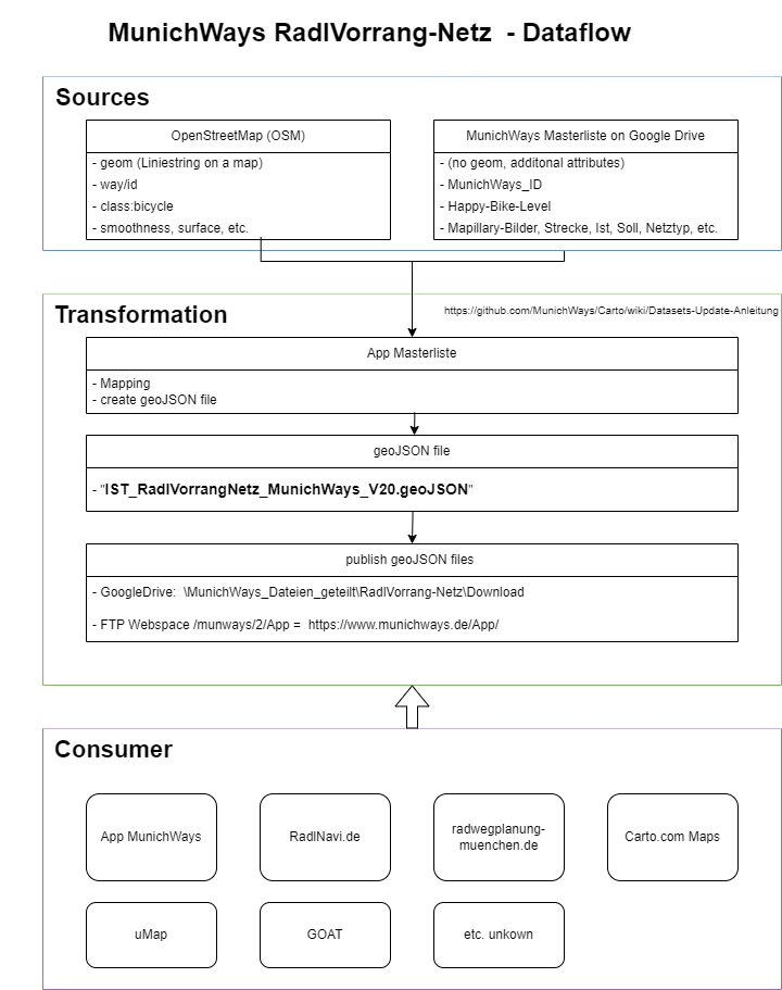
- Import and Export features to import and combine the "Masterliste" with geo data from OSM or Carto. Export as GeoJSON on our webserver as source for the app
- https://github.com/MunichWays/Carto/wiki/Datasets-Update-Anleitung
- Repository: https://github.com/MunichWays/munich-ways-app
- Website: https://www.munichways.de/app/
- Repository: https://github.com/MunichWays/radlnavi
- Website: https://www.radlnavi.de/
The routing is integrated into the MunichWays app.
Explore our OpenStreetMap (OSM) wiki and scripts.
- Repository: https://github.com/MunichWays/OSM
- Website: https://www.munichways.de/osm/
Discover and contribute to a collection of good examples showcasing bicycle infrastructure, aiming to inspire others to advocate for better cycling facilities.
- Repository: https://github.com/MunichWays/bike-infrastructure
- Webside: https://www.munichways.de/infrastruktur-elemente/
So einfach wie Radfahren
www.munichways.de, in Kooperation mit Green City e.V.