The repository contains the source code of GPSdataColVis. See the following paper for more details:
A Alia, M Maree, M Chraibi.(2021). On the exploitation of GPS-based data for real-time visualisation
of pedestrian dynamics in open environments. Behaviour & Information Technology, 1-15.
See also citation for how to cite.
GPSdataColVis is a hybrid Android-based mobile application and web-based application that has capabilities to collect, process, store and visualise the GPS data of the users’ current positions in real time at large-scale open environments.
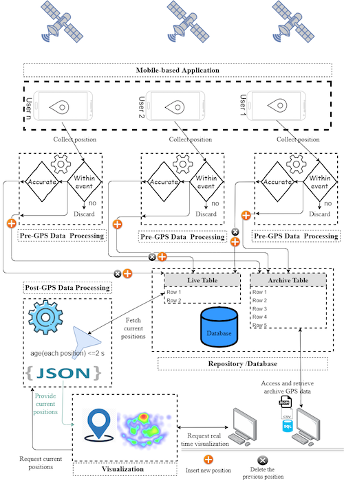
The following figure illustrates the overall architecture of the proposed system.
- The system (Android-based mobile application) collects pedestrians' GPS data every second and estimates their horizontal accuracy before sending them to the web server for further processing and storing.
- The system provides access to online real-time visualised maps that depict pedestrian movements along with real-time heat maps for spotting crowded areas.
- An archive of collected GPS data with multiple formats (SQL, JSON, CSV).
Each user's position contains the following fields:
Id: a unique identifier for position.mobileId: an identifier for mobile/user.Latitude: latitude of user's position.Longitude: longitude of user's position.Timestamp: date and time for obtained position.Accuracy: horizontal accuracy of user's position.
-
A hosted web server with the following specifications to host and run the Web-based application:
- PHP (at least V. 7)
- MySQL database
- public IP or domain
-
Android Development Environment to add the domain(URL) of web-based application to Android-based mobile application.
-
Android-based smartphones that support Android 4.0.3 or above to install and run the Android-based mobile application (Android Application package (APK)).
git clone https://github.com/PedestrianDynamics/GPSdataColVis.git
To set up the web-based application, please follow the following instructions:
- Login to the cPanel for the hosted web server using the URL, username and password that you got from your web hosting service.
- Creating the database and its tables:
- From database icons, click on phpMyAdmin icon.
- If the web hosting service gives you an empty database, click on its name and copy the following SQL statements into SQL shell and click on run button to execute the SQL statements.
CREATE TABLE `current` (
  `id` int(11) NOT NULL,
  `lang` double NOT NULL,
  `lat` double NOT NULL,
  `timestamp` timestamp NOT NULL DEFAULT current_timestamp() ON UPDATE current_timestamp(),
  `androidId` varchar(60) COLLATE utf8_unicode_ci NOT NULL,
  `accuracy` double NOT NULL
) ENGINE=InnoDB DEFAULT CHARSET=utf8 COLLATE=utf8_unicode_ci;
CREATE TABLE `traces` (
  `id` int(11) NOT NULL,
  `lang` double NOT NULL,
  `lat` double NOT NULL,
  `timestamp` timestamp NOT NULL DEFAULT current_timestamp() ON UPDATE current_timestamp(),
  `androidId` varchar(60) COLLATE utf8_unicode_ci NOT NULL,
  `accuracy` double NOT NULL
) ENGINE=In
Otherwise, (if the web hosting service does not give you any database), click on SQl shell and execute the following SQL statements:
CREATE DATABASE database_name;

USE database_name;

CREATE TABLE `current` (
  `id` int(11) NOT NULL,
  `lang` double NOT NULL,
  `lat` double NOT NULL,
  `timestamp` timestamp NOT NULL DEFAULT current_timestamp() ON UPDATE current_timestamp(),
  `androidId` varchar(60) COLLATE utf8_unicode_ci NOT NULL,
  `accuracy` double NOT NULL
) ENGINE=InnoDB DEFAULT CHARSET=utf8 COLLATE=utf8_unicode_ci;
CREATE TABLE `traces` (
  `id` int(11) NOT NULL,
  `lang` double NOT NULL,
  `lat` double NOT NULL,
  `timestamp` timestamp NOT NULL DEFAULT current_timestamp() ON UPDATE current_timestamp(),
  `androidId` varchar(60) COLLATE utf8_unicode_ci NOT NULL,
  `accuracy` double NOT NULL
) ENGINE=In
-
Uploading web-based application files into a web root (public_html or WWW) directory, please follow the following instructions
- Select files/files manager, select a web root directory from left tree.
- Select upload files tab to upload the files of the directory
GPSdataColVis\src\WebApp.
-
Configuring the Connection to MySQL Database. To configure the MySQL database connection, you need to set MySQL connection information in
GPSdataColVis\src\WebApp\db.phpfile as follows:<?php $servername = "localhost"; //MySQL username and password are obtained from web hosting service or mostly from cPanel. $username = "Please add MySQL username"; //Kindly notice this line $password = "Please add MySQL password"; //Kindly notice this line $dbName="Please add database_name"; //Kindly notice this line // Create connection $conn = new mysqli($servername, $username, $password,$dbName); // Check connection if ($conn->connect_error) { die("Connection failed: " . $conn->connect_error); } ?>
To add the required public URL, you need firstly to prepare the Android Development Environment. Please follow the following steps:
-
Download and install Android studio from the link.
-
Importing the GPSdataColVis\src\Android-based mobile application into Android Studio:
- Open Android studio.
- Select Import Project (Eclipse ADT, Gradle, etc.).
- Browse to the directory where you placed the Android-based mobile application and click OK.
-
Adding the required public URL:
- Open
GPSdataColVis\src\AndroidMobileApp\app\src\main\java\com\example\amm\ BackgroundTask.javafile. - In line 30, please add the domain/URL of the web-based application
String url1= "add the domain of the web-based application here/insertLocation.php"; - Open
-
Build and run the Android-based mobile application, for more information, please visit this link.
-
Generating an APK file that can easily be installed on any Android device, to do that please follow these steps:
- In the Android menu, go to Build > Build Bundle(s) / APK (s) > Build APK(s).
- Android Studio will start building the APK for you. Once done, a pop-up on the bottom right will notify you of its completion. Click the ‘locate’ button in this dialog.
- The
locatebutton should open File Explorer with the debug folder open that contains a file called "app-debug.apk".
- Install the APK file on Android-based smartphones.
- Open the Android-based mobile application, and follow the instructions from the Android-based mobile application.
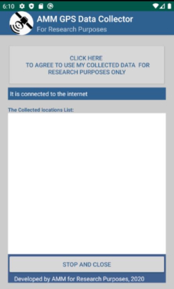
- Click on the agreement button to start collecting and submitting GPS data of user position to the web-based application.
A real-world experimental scenario was conducted to evaluate the proposed system, and the collected GPS data is available in GPSdataColVis\Datasets with different formats, the above data section explains the fields of each row in the dataset.
The experiment was conducted in several open areas at the new campus at An-Najah National University in Palestine. The focus was on the open theatre area. The area of the new campus is about 137.000 square meters, and its bounding box is identified by the following latitude and longitude: (32.22682, 35.22493), (32.2294, 35.2196).
Both an open area with no high buildings and another open area that is surrounded by high buildings were selected. Nine users with different types of Android-based smartphones have installed the application and participated in this experiment.
If you use GPSdataColVis or the real dataset, please cite the following paper:
@article{alia2021exploitation,
  title={On the exploitation of GPS-based data for real-time visualisation of pedestrian dynamics in open environments},
  author={Alia, Ahmed and Maree, Mohammed and Chraibi, Mohcine},
  journal={Behaviour \& Information Technology},
  pages={1--15},
  year={2021},
  publisher={Taylor \& Francis}
}

