Motivation: When opening a geojson file in QGIS, a random color is assigned. While it is possible to use specific geojson properties to replace the default (random) color, this becomes a tedious for large number of files.
This plugin allows to set the color of a set of geojson files with a single click.
Official page of the plugin in the QGIS plugin repository:
- Download a release from the QGIS Plugin repository or the Github release page (
geojson_filling.zip). - In
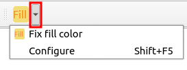
QGISgo toPlugins/Manage and Install Plugins ..., click onInstall from ZIP, and select thegeojson_filling.zipfile. - Afterwards you find the plugin in one of the top toolbars of QGIS - see the
red rectangle in the image below.

- cd
QGIS-Plugin-Geojson-Filling/geojson_filling - install
pb_toolwithpip install pb_tool - Run
pb_tool zipwhich creates
├── QGIS-Plugin-Geojson-Filling/geojson_filling/zip_build
│   ├── geojson_filling
│   ├── geojson_filling.zip
│   ├── !README.txt
- Activate the plugin in QGIS as shown above (see
Installation from Release)
The plugin adds a button which allows to modify the rendering of all (or all selected) vector layers (i.e. the loaded geojson files) in the current QGIS session. Instead of the default random color, a specific property of each geojson file is used for rendering the corresponding layer.
By default, the plugin is looking for a property named fill as shown in the
example below.
{
    "features": [
        {
            "geometry": {
                "coordinates": [
                    [
                        [
                            13.036073975554306,
                            52.39652411784479
                        ],
                        [
                            13.03608716557477,
                            52.39651801475642
                        ],
                        [
                            13.036073975554306,
                            52.39652411784479
                        ]
                    ]
                ],
                "type": "Polygon"
            },
            "properties": {
                "fill": "#ffff00",
                "fill-opacity": 0.5
            },
            "type": "Feature"
        }
    ],
    "type": "FeatureCollection"
}
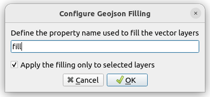
The name of the property may be changed using the plugin options (by clicking on the small arrow on the right side of the icon).
Clicking on Configure opens the following dialog which allows to change the
property name.
By default, the filling operation is limited to the current layer selection. This behavior can be changed in the configuration dialog shown above.
Two example files are provided under examples/cars.json and
examples/single_car.json.
Instruction for plugin development are provided here.

