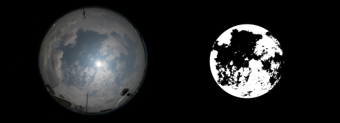
This repository is a minimalist working version of cloud coverage computation. This is inspired from the research performed in the following publications:
S. Dev, Y. H. Lee, S. Winkler, Color-based segmentation of sky/cloud images from ground-based cameras, IEEE Journal of Selected Topics in Applied Earth Observations and Remote Sensing, vol. 10, no. 1, pp. 231-242, Jan 2017.
S. Dev, Y. H. Lee, S. Winkler, Systematic Study of Color Spaces and Components for the segmentation of sky/cloud images, Proc. IEEE International Conference on Image Processing (ICIP), Oct. 2014.
- Please store the sample input image inside the
imagefolder. Please note that our images are captured by WAHRSIS, and have a fixed dimension of5184x3456pixels. - Run the script
python2 find_coverage.py. This computes the following:- Generates the resultant binary image, and saves it inside the
imagefolder. - Outputs and displays the cloud coverage ratio. Please note that we neglect the black border around the central circular region, while computing the cloud coverage value.
- Generates the resultant binary image, and saves it inside the
