The goal of geosom is to achieve
Spatially-Aware Self-Organizing Maps(GeoSOM) Model in R.
You can install the development version of geosom from github:
# install.packages("devtools")
devtools::install_github("SpatLyu/geosom",build_vignettes = T,dep = T)library(geosom)
data(pmc)
set.seed(20220724)
tictoc::tic()
geosom_bestparam(data = pmc,
coords = c("centroidx","centroidy"),
wt = c(seq(0.1,1,by = 0.1),2:5),
xdim = 4:10, ydim = 4:10,cores = 6) -> g_bestparam
tictoc::toc()
## 53.59 sec elapsedg = geosom(data = pmc, coords = c("centroidx","centroidy"), wt = .9,
grid = geosomgrid(4,4,topo = "rectangular",
neighbourhood.fct = "gaussian"))g_superclass = geosom_superclass(g,6,method = 'pam')
g_superclass
## [1] 1 2 2 2 3 1 2 2 3 3 4 5 3 4 4 6g_label = geosom_clusterlabel(g,g_superclass)
g_label
## [1] 2 2 3 4 2 6 5 2 2 5 6 2 3 3 6 6 5 3 2 6 2 4 2 4 5 1 1 2 2 1 3 3 2 4 4 2 2
## [38] 4 2 2 1 4 5 2 6 3 5 2 4 1 1 3 1 2 2 1 4 2 3 1 2 5 2 3 2 4 1 6 6 3 1 2 3 2
## [75] 2 2 2 4 3 4 4 4 2 2 1 2 4 4 1 6 1 4 2 2 3 2 3 3 4 3 4 3 2 2 3 5 3 1 3 2 6
## [112] 6 1 2 5 6 5 2 2 1 2 3 2 2 3 3 2 2 4 2 2 3 1 6 3 2 2 3 3 3 1 5 1 6 1 4 1 4
## [149] 2 5 4 2 4 4 3 2 2 1 4 2 6 5 5 3 6 2 1 2 3 2 6 2 1 5 3 2 1 2 2 2 3 3 3 2 2
## [186] 3 3 2 1 1 4 4 4 6 2 2 1 1 3 4 4 1 3 2 3 3 2 2 2 3 2 6 1 6 2 3 1 2 1 3 5 3
## [223] 4 2 5 5 1 6 6 5 2 2 4 3 3 1 6 1 2 1 3 2 2 3 1 2 2 1 2 3 5 4 1 4 1 2 6 1 3
## [260] 5 2 1 1 3 2 1 2 3 3 6 3 1 4 3 3 1 1 1library(sf)
library(dplyr)
library(ggplot2)
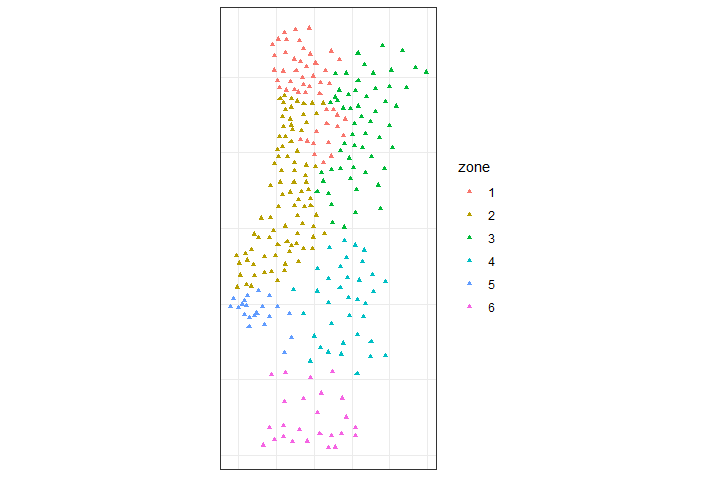
pmc %>%
mutate(zone = as.factor(g_label)) %>%
st_as_sf(coords = c("centroidx","centroidy")) %>%
ggplot() +
geom_sf(aes(col = zone),size = 1.25,shape = 17) +
scale_color_discrete(type = 'viridis') +
theme_bw() +
theme(axis.text = element_blank(),
axis.ticks = element_blank())