GPS Logger for iOS
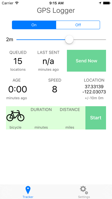
This app is an experiment at gathering data from an iPhone to test the Core Location API and its various settings. The app tracks:
- GPS location
- Motion State (walking, running, driving, cycling, stationary)
- Battery level
The app gathers data with no network connection and stores locally on disk. The data is sent to the server in a batch at an interval set by the user.
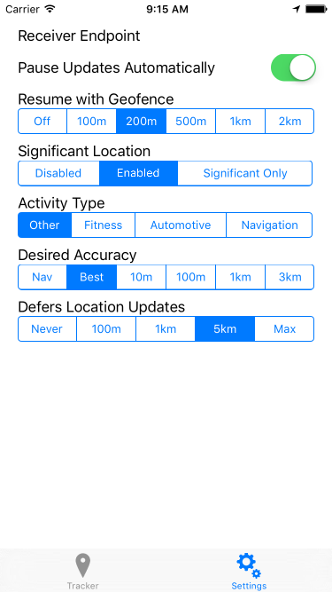
There are many settings available in the settings tab which allow you to adjust properties of the Core Location API.
Screenshots
API
The app will post the location data to the configured endpoint. The POST request will be an array of GeoJSON objects inside a property called "locations". This may look like the following:
{
  "locations": [
    {
      "type": "Feature",
      "geometry": {
        "type": "Point",
        "coordinates": {
          "latitude": 37.331800,
          "longitude": -122.030581
        }
      },
      "properties": {
        "timestamp": "2015-10-01T08:00:00-0700",
        "altitude": 0,
        "speed": 4,
        "horizontal_accuracy": 30,
        "vertical_accuracy": -1,
        "motion": ["driving","stationary"],
        "pauses": false,
        "activity": "other_navigation",
        "desired_accuracy": 100,
        "deferred": 1000,
        "significant_change": "disabled",
        "locations_in_payload": 1,
        "battery_state": "charging",
        "battery_level": 0.89
      }
    }
  ]
}
The properties on the location object are as follows:
timestamp- the ISO8601 timestamp of theCLLocationobject recordedaltitude- the altitude of the location in metersspeed- meters per secondhorizontal_accuracy- accuracy of the position in metersvertical_accuracy- accuracy of the altitude in metersmotion- an array of motion states detected by the motion coprocessor. Possible values are:driving,walking,running,cycling,stationary. A common combination isdrivingandstationarywhen the phone is resting on the dashboard of a moving car.pauses- boolean, whether the "pause updates automatically" preference is checkedactivity- a string denoting the type of activity as indicated by the setting. Possible values areautomotive_navigation,fitness,other_navigationandother. This can be set on the settings screen.desired_accuracy- the requested accuracy in meters as configured on the settings screen.deferred- the distance in meters to defer location updates, configured on the settings screen.significant_change- a string indicating the significant change mode,disabled,enabledorexclusive.locations_in_payload- the number of locations that were sent in the batch along with this locationbattery_state-unknown,charging,full,unpluggedbattery_level- a value from 0 to 1 indicating the percent battery remaining.
Contributing
Esri welcomes contributions from anyone and everyone. Please see our guidelines for contributing.
License
Licensed under the Apache License, Version 2.0 (the "License"); you may not use this file except in compliance with the License. You may obtain a copy of the License at
http://www.apache.org/licenses/LICENSE-2.0
Unless required by applicable law or agreed to in writing, software distributed under the License is distributed on an "AS IS" BASIS, WITHOUT WARRANTIES OR CONDITIONS OF ANY KIND, either express or implied. See the License for the specific language governing permissions and limitations under the License.

