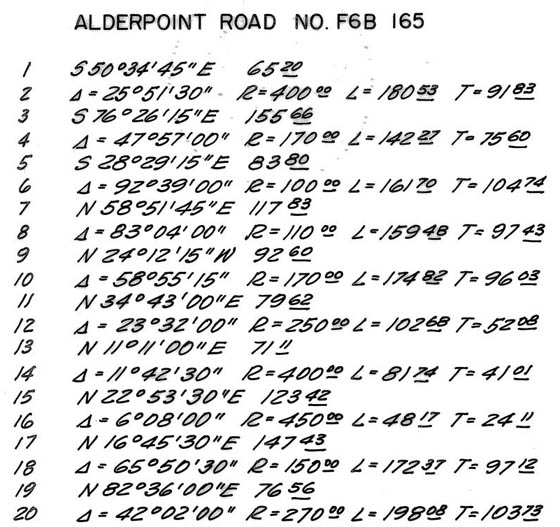
This tool allows the user to create a command file from line table data. The command file can then be processed to create AutoCAD LW polylines. A typical line table looks like this ...
As a line table may contain many dozens of lines it can be error prone to enter the line and curve data interactively. The command file approach has a few advantages.
- Command files can be easily checked against the original line table data
- Command file processing lists derived segment values and flags non-tangent curves
- Use of polylines ensures all segments are contiguous
Each line of a command file describes one polyline segment or auxiliary operation. Blank lines and lines starting with a hash (#) are ignored as comments. A list of polylines and a points list are maintained as the command file is processed. New segments are added to the end of the current polyline, i.e. the last polyline in the list of polylines. Each non-comment line consists a command (case-insensitive) followed by zero or more parameters separated by space.
BEGIN <point_id>
BEGIN <northing> <easting>
Start a new polyline at the specified point or coordinates.
POINT <point_id> LAST <description>
POINT <point_id> <northing> <easting> <description>
Save the last ployline endpoint or specified coordinates in the points list.
<point_id> is case insensitive and can contain no spaces. The <description> is optional.
<quadrant> <bearing> <distance>
Add a line segment. <quadrant> is 1=NE, 2=SE, 3=SW, 4=NW.
<bearing> is in Degrees-Minutes-Seconds (DD.MMSS).
<direction> <delta> <radius>
Add a curve tangent to previous segment. <direction> is L=Left, R=Right.
<delta> is in Degrees-Minutes-Seconds (DDD.MMSS).
<direction> <delta> <radius> <quadrant> <bearing>
Add a non-tangent curve segment. Radial <quadrant>/<bearing> is from BC to RP.
<deflection> <delta> <distance>
Add a line segment using a deflection angle. <deflection> is DL=Left, DR=Right.
<delta> is in Degrees-Minutes-Seconds (DDD.MMSS).
BRANCH - Start a new polyline from the endpoint of the current polyline.
RESUME - Resume with the polyline prior to last BRANCH.
UNDO - Remove the last segment from the current polyline.
CLOSE <point_id> - Calculate closure from endpoint of current polyline to specified point.
Processing of the line data produces a listing showing commands and derived line and curve data. Non-tangent segments following a curve are flagged. A PNEZD list of points is included at the bottom of the listing.
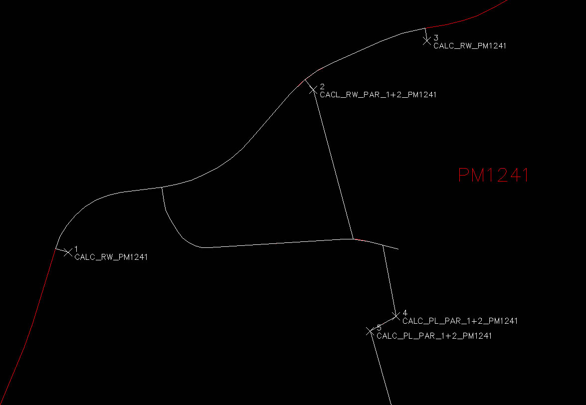
See linedata-demo.txt and parcel map PM1241 in the data directory for an example.
# Alderpoint Rd
# PM1241 sheet 2/3 and line table sheet 3/3.

# Begin on east edge R/W at line 18
POINT 1 1929390.126 6074201.714 CALC_RW_PM1241
BEGIN 1
4 73.1430 25.00

# Radial calculated from line 17 for non-tangent curve
R 65.5030 150.00 2 73.1430
1 82.3600 76.56

# Road B PM1241 detail D
POINT XN_ROAD_B LAST

# Alderpoint Rd PM1241 line 20
L 42.0200 270.00
1 40.3400 108.71

# Property line parcels 1 & 2 PM1241 detail A
R 10.1240 220.00
BRANCH
2 39.1320 25.00
POINT 2 LAST CACL_RW_PAR_1+2_PM1241
RESUME

# Alderpoint Rd PM1241 line 23
R 15.0705 220.00
1 65.5345 103.79
R 14.5330 330.00

# South edge R/w
DR 90.0000 25.00
POINT 3 LAST CALC_RW_PM1241

# Road B PM1241 detail D
BEGIN XN_ROAD_B
2 7.2400 26.03
L 24.5315 90.00
2 32.1715 25.64
L 61.2515 65.00
1 86.1730 253.50

# Road B PM1241 detail A
R 6.4415 150.00
POINT RB06A LAST
R 11.4045 150.00
2 75.1730 26.19
POINT RB07A LAST
2 75.1730 30.40

# Property line parcels 1 & 2 PM1241 detail A
BEGIN 2
2 15.0000 290.24
CLOSE RB06A

# Fence line PM1241 details A & C
BEGIN RB07A
2 10.3620 136.38
POINT 4 LAST CALC_PL_PAR_1+2_PM1241
3 60.1110 55.91
POINT 5 LAST CALC_PL_PAR_1+2_PM1241
2 15.5230 354.22
1 81.5415 223.83
1 61.2510 157.32
2 85.0245 301.26
3 4.3135 180.94
3 18.1330 112.14
BRANCH
2 65.5800 112.66
RESUME
3 18.1330 77.21

