MPAS Plotting
This repository contains a number of examples related to plotting MPAS model output with Python. It contains examples using MatPlotLib and will later contain examples using NCAR's PyNGO as well as any other NCAR NCL Python modules that appear.
The goal of this repository is to function as a set of examples and reference for Python Modules that can be used to create model output plots.
Note: Files that are named with 'clean' are the same as the files with the same name, but have less documentation and code comments.
Tutorial Contents
- mpas_patches - Tutorial for plotting each indivual MPAS Grid Cell
- ll-plotting - Tutorial for plotting a normal lat, lon grid (using convert_mpas).
Readme Contents
Introduction to Python Modules
Plotting Meteorological data in Python is a multi-module endeavour and is undoubtedly a bit overwhelming. Some modules even contain references to each other, which can be even more consufing. I hope to break this process down into more manageable chunks, and also point you in the right direction to find the information you need.
One feature that Fortran has over vanilla Python are its n-dimensional arrays and its operations around those arrays. Out of the box Python allows you to have multidimensional 'lists', but these list of lists are large and inefficient for vector and scaler operations.
The Numpy module enables smaller, more efficient n-dimensional arrays in a very similar
approach to Fortran n-d arrays. With useful intrinsics such as shape,
size, ndim and others, which allow you to inspect data as you see fit.
It also enables a load of optimized mathematical functions that you can dream of: https://docs.scipy.org/doc/numpy/reference/routines.math.html.
Python NetCDF Modules and other Met Datatypes
There are a few modules out there that can support reading, creating and manipulating NetCDF datafiles. These include: Scipy NetCDF, NetCDF4 Dataset, xArray, as well as NCAR's PyNIO (which is an NCL wrapper).
There are multitude of modules to choose from, but I recommend starting with Scipy's NetCDF module to start. It contains the most examples and is the best documented; however, it cannot open NetCDF4, but you can use UNIDATA's NetCDF4 Dataset instead, its also easy to use, but its documentation could be better. The examples in this tutorial use the UNIDATA's NetCDF4 module.
If you need to open other Datatypes such as Grib, HDF, etc. PyNIO is currently your best choice: https://www.pyngl.ucar.edu/Nio.shtml. However, with the shift to Python and PyNIO going into maintenance mode, it may be worth becoming familiar with Python alternatives. Here is a list of common met datatypes and modules that can open them:
(Note: Besides Scipy's NetCDF and Unidata's NetCDF4 I don't know how many of these are on cheyenne or capser)
The free alternative to creating plots in MATLAB, MPL was created by neurobiologist to plot EEG of his patients, it has perhaps the largest open source python modules out there.
It is flexible beyond belief to fit a variety of application and can be used to create publication-quality figures (though you may disagree coming from NCL) to real time forecasting plots or overlays.
It has been extended to be used Geogrpahically/Meterographically with Basemap and Cartopy.
These two modules are built on top of MatPlotLib and allow the complicated handling of projections and converting between projections.
Cartopy is a newer module, but is still in alpha and lacking in features and documentation which makes it difficult to use, but it appears to be developing rapidly.
Basemap, the original of the two modules, is much better documented and contains more features and more examples and is much easier to use at the current moment. I recommend using Basemap while Cartopy gains documentation and features.
Examples within this tutorial use Basemap; however, once I see Cartopy gaining more traction and better documentation (and I get more familar with it) I will create examples using it.
To use Python with the modules above on Cheyenne and Casper. We'll need to
create a Python virtual environment that contains these modules. Thankfully,
CISL has created a command that will do that for us: ncar_pylib. Once you
have loaded a Python (version >=3.6.4) run ncar_pylib in your terminal window
and you'll have access to all the above modules.
Python 2 will soon not be maintained. All of these examples use Python 3. Use Python 3.
Quick Introduction to MatPlotLib
MatPlotLib can be a confusing module to use and understand at first, but with practice and understanding of how its mechanisms work, plotting becomes much easier.
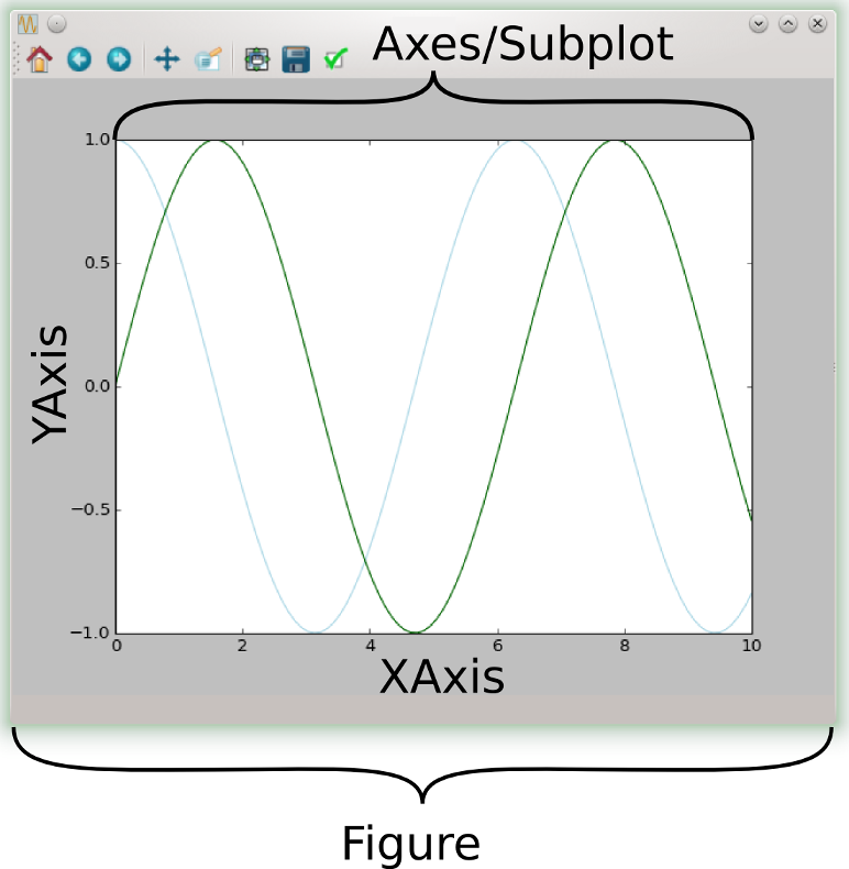
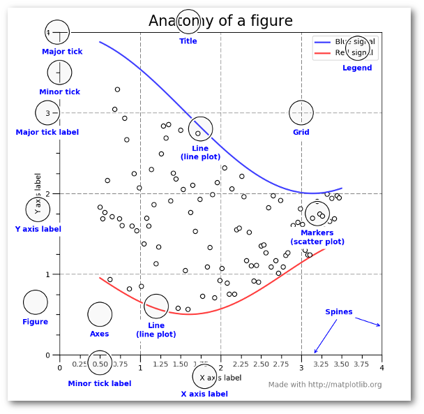
Above, are two images that I wish I had when I started using MPL. They both give an overview of the anatomy of a MPL Figure and its parts.
You'll see on the image on the left, those two main parts are the Figure, and the Axes/Subplot. The Figure, is highest in the hierarchy of MPL, and it contains 1 or more Axes/Subplots. An Axes/Subplot represent an individual plot or graphic.
So, for instance, the plots above contain a single Axes/Subplot, but are both,
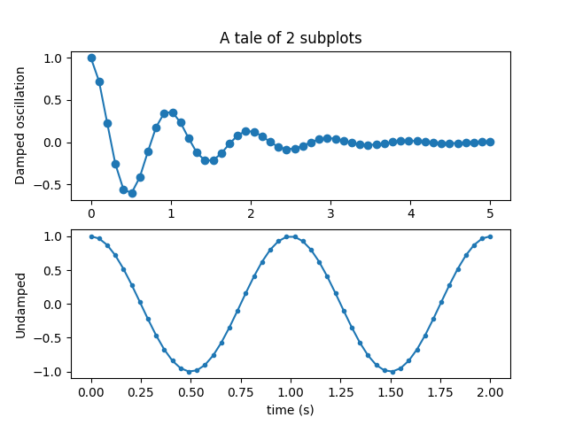
separately, their own figure. Often times, it is needed to create multiple
subplots in a single figure, which MPL allows, such as: 
If you are wanting to create a plot that is not within this tutorial. I recommend taking a look at the MPL Example Gallery and the MPL Tutorial Page for a load of examples and tutorials on everything MPL.
Module and other Helpful References
- Plotting
- Meteorological and Geographic Plotting
- Python NetCDF Tools
- Numpy
Helpful References and Guides
- Anatomy Of MatplotLib
- MPL Tutorial Page
- MPL Example Gallery
- MPL Color Maps Reference
- MPL Plot Style Reference
- Figure Documentation
- Axes Documentation
References & Credits
- For examples and the Antomy of MatPlotLib Image used in and Introduction to MatPlotLib
- For help creating mpas_patches
- Anatomy of A Figure Image
Todo:
- Add more examples (espcially 2D examples)
- Histogram, Barplots, Scatter Plots etc.
- Add a Subplot example (possibly using grid spacing)
- Add an example longitude or latitude 'slize' of a variable or two.
- Clean up the helpful reference and guide list into one list and not two
- Add documentation to
mpas_patches.py - Find a way to apply patches to Cartopy

