StarCharter is a versatile command-line tool for producing charts of the
night sky. Charts can be generated relative to the local horizon, depicting the
sky as seen from a particular location at a particular time, or as a star atlas
in equatorial or galactic coordinates. A large array of configuration options
are available to allow the charts to be fully customised.
StarCharter can depict the positions of solar system objects - planets,
asteroids and comets - if the tool
ephemerisCompute is also
installed. The paths of these objects across the sky over a specified time
period can also be shown.
Charts can be generated in either PNG (bitmap graphics) format for quick viewing and use online, or in PDF/SVG/EPS (vector graphics) formats for subsequent typesetting or editing in a vector graphics package such as Adobe Illustrator or Inkscape.
StarCharter was originally developed to produce star charts for the website
https://in-the-sky.org.
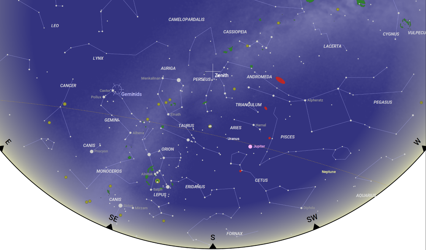
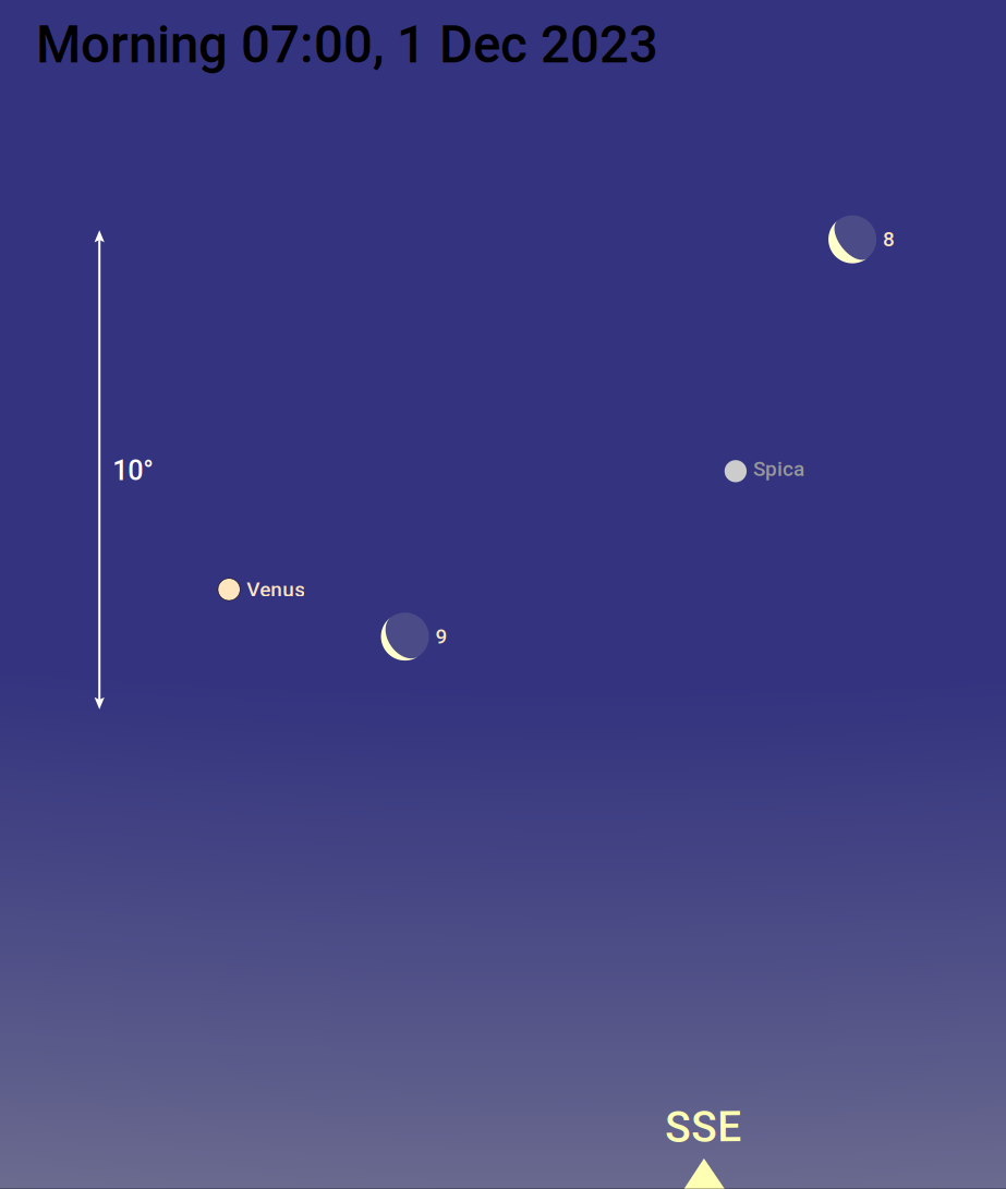
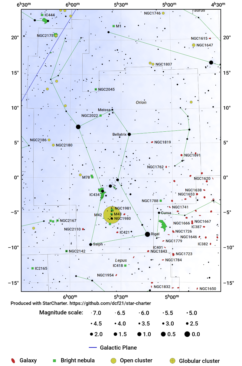
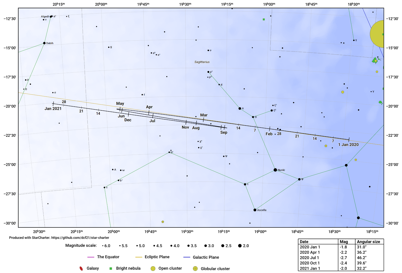
This section shows a small number of examples of the output of StarCharter:
- The sky as seen looking south from London on 1 December 2023:
Generated by this script.
- The location and phase of the Moon as it passes Spica and Venus on 1 December 2023:
Generated by this script.
- A chart of the constellation of Orion:
Generated by this script.
- A chart of the path of Jupiter in the year 2020:
Generated by this script.
This code is distributed under the Gnu General Public License. It is (C) Dominic Ford 2015 - 2024.
StarCharter is written in C and runs in Linux, macOS, and other Unix-like
operating systems. A Docker container is provided to facilitate running
StarCharter in the widest possible range of operating systems. The
installation scripts require Python 3. StarCharter uses libcairo to
produce its graphical output.
The build process requires a minimum of 4GB RAM. Note that Docker Desktop for
macOS imposes a default memory limit of 2GB, which needs to be increased to
build StarCharter successfully.
First make a clone of the code in this GitHub repository:
git clone https://github.com/dcf21/star-charter.git
If you intend to show solar system objects on star charts, then you should also
clone ephemeris-compute, to fetch the positions of these objects from the
DE430 ephemeris:
git clone https://github.com/dcf21/ephemeris-compute-de430.git
If you wish to run StarCharter locally (not within a Docker container), then
you must run the shell scripts setup.sh in each repository to download the
data required by each tool and to compile the software. Run the
ephemeris-compute-de430 setup script first, and then the star-charter setup
script. These scripts download various data from the internet, including the
DE430 solar system ephemeris, star catalogues, deep sky catalogues, and an
image of the Milky Way to use to shade the background of star charts.
The total download size will be around 500 MB, and it will take around 15-20 minutes to process the downloaded files.
If you would rather run StarCharter within a Docker container, then a
Dockerfile is provided to build such a container. This automatically
installs all the software's dependencies within the containerised environment
to make the build process as simple as possible. Additionally, a docker compose script is provided, which automatically build a selection of example
star charts.
To build the StarCharter container (this takes 20 minutes):
docker compose build
To generate a selection of example charts, which are placed in the directory
examples/output:
docker compose run star-charter
To make other star charts, open a shell within the Docker container as follows:
docker run -it star-charter:v5 /bin/bash
The configuration options for each star chart are specified in a configuration file, where options are specified in the format
<option_name>=<option_value>
The available options include which portion of the sky should be charted, what
labels should be placed on the chart, etc. The directory examples within
this repository contains numerous example configuration files, and there is a
complete list of all the available configuration options below.
There are some examples in the examples directory, and so a good starting
point is to generate one of these:
cd examples
../bin/starchart.bin orion.sch
This will generate a chart of the constellation Orion in the output
directory. Three files are created, in PNG, SVG and PDF formats.
The file orion.sch reads as follows:
DEFAULTS
ra_central=5.5
dec_central=4.0
angular_width=29.0
mag_min=7
width=15.0
aspect=1.41421356
show_grid_lines=1
constellation_boundaries=1
constellation_sticks=1
coords=ra_dec
projection=stereographic
star_names=1
star_flamsteed_labels=0
constellation_names=1
plot_galaxy_map=1
plot_equator=0
plot_ecliptic=0
plot_galactic_plane=1
font_size=1.2

CHART
output_filename=output/orion.png

CHART
output_filename=output/orion.svg

CHART
output_filename=output/orion.pdf
Settings are arranged in blocks which are headed by the words DEFAULTS or
CHART. Settings in a DEFAULTS block do not themselves produce a star chart,
but change the default settings which are applied to all subsequent charts.
Settings in a CHART relate to a specific chart that is to be rendered, and do
not affect any subsequent charts which may be rendered later in the same
configuration file.
The file above configures the required parameters to produce a chart of the constellation Orion, and makes these the default settings. It then produces three copies of the star chart, in three different graphic formats.
A complete list of all the configuration settings which are recognised are listed below under 'Configuration settings'.
The following settings can be included in a StarCharter configuration file:
alt_central- The local altitude of the centre of the plot; degrees. This setting is only used ifcoords=alt_az.angular_width- The angular width of the star chart on the sky; degreesaspect- The aspect ratio of the star chart: i.e. the ratio height/widthaxis_label- Boolean (0 or 1) indicating whether to write "Right ascension" and "Declination" on the vertical/horizontal axesaxis_ticks_value_only- If 1, axis labels will appear as simply "5h" or "30 deg". If 0, these labels will be preceded by alpha= or delta=az_central- The local azimuth of the centre of the plot; degrees. This setting is only used ifcoords=alt_az.cardinals- Boolean (0 or 1) indicating whether to write the cardinal points around the edge of alt/az star chartschart_edge_line_width- Line width to use when marking the edge of the chart. Default 2.5.constellation_boundaries- Boolean (0 or 1) indicating whether we draw constellation boundariesconstellation_boundary_col- Colour to use when drawing constellation boundariesconstellation_highlight- Optionally, highlight the boundary of one particular constellation, identified by a three-letter abbreviation.constellation_label_col- Colour to use when writing constellation namesconstellation_names- Boolean (0 or 1) indicating whether we label the names of constellationsconstellation_stick_col- Colour to use when drawing constellation stick figuresconstellation_stick_design- Select which design of constellation stick figures we should draw. Set to eithersimplifiedorrey. See https://github.com/dcf21/constellation-stick-figures for more information.constellation_sticks_line_width- Line width to use when drawing constellation stick figures. Default 1.4.constellation_sticks- Boolean (0 or 1) indicating whether we draw constellation stick figuresconstellations_capitalise- Boolean (0 or 1) indicating whether we capitalise the names of constellations.constellations_label_shadow- Boolean (0 or 1) indicating whether to draw a shadow behind the names of the constellations.coords- Select which celestial coordinate system to use when specifying the centre of the plot. Set tora_dec,galacticoralt_az.copyright_gap_2- Spacing of the copyright text beneath the plotcopyright_gap- Spacing of the copyright text beneath the plotcopyright- The copyright string to write under the star chartdec_central- The declination of the centre of the plot; degrees. This setting is only used ifcoords=ra_dec.draw_ephemeris- Definitions of ephemerides to draw. Each definition should take the form of:<bodyId>,<jdMin>,<jdMax>(see above). To draw multiple ephemeride, specify this setting multiple times within your configuration file.dso_cluster_col- Colour to use when drawing star clustersdso_galaxy_col- Colour to use when drawing galaxiesdso_label_col- Colour to use when writing the labels for deep sky objectsdso_label_mag_min- Do not label stars fainter than this magnitude limit (default: unlimited)dso_mag_min- Only show NGC objects down to this faintest magnitudedso_mags- Boolean (0 or 1) indicating whether we label the magnitudes of NGC objectsdso_names- Boolean (0 or 1) indicating whether we label the names of NGC objectsdso_nebula_col- Colour to use when drawing nebulaedso_outline_col- Colour to use when drawing the outline of deep sky objectsdso_point_size_scaling- Size scaling of deep sky object symbols. Default 1.dso_symbol_key- Boolean (0 or 1) indicating whether we include a key to the symbols used to represent deep sky objectsecliptic_col- Colour to use when drawing a line along the eclipticephemeris_autoscale- Boolean (0 or 1) indicating whether to auto-scale the star chart to contain the requested ephemerides. This overrides settings for ra_central, dec_central and angular_width.ephemeris_col- Colours to use when drawing ephemerides for solar system objects. If this setting is supplied multiple times, then the list of supplied colours are used in a cyclic loop for all the solar system objects to be drawn.ephemeris_compute_path- The path to the toolephemerisCompute, used to compute paths for solar system objects. See https://github.com/dcf21/ephemeris-compute-de430. If this tool is installed in the same directory as StarCharter, the default value should be <../ephemerisCompute/bin/ephem.bin>.ephemeris_epochs- List of JD time epochs for which we should create points along each solar system ephemeris. If empty, then points are created automatically. This list must have the same length as <ephemeris_epoch_labels>. To draw multiple epochs, specify this setting multiple times within your configuration file.ephemeris_epoch_labels- List of text labels for the points we create along each solar system ephemeris. If empty, then points are created automatically. This list must have the same length as <ephemeris_epochs>. To draw multiple epochs, specify this setting multiple times within your configuration file.ephemeris_label_col- Colours to use when labelling ephemerides for solar system objects. If this setting is supplied multiple times, then the list of supplied colours are used in a cyclic loop for all the solar system objects to be drawn.ephemeris_style- Select the style to use when showing the tracks of solar system objects. Set totrack,side_by_sideorside_by_side_with_track.equator_col- Colour to use when drawing a line along the equatorfont_family- The font family to use when rendering all text labels.font_size- A normalisation factor to apply to the font size of all text (default 1.0)galactic_b_central- The galactic latitude of the centre of the plot; degrees. This setting is only used ifcoords=galactic.galactic_l_central- The galactic longitude of the centre of the plot; degrees. This setting is only used ifcoords=galactic.galactic_plane_col- Colour to use when drawing a line along the galactic planegalaxy_col0- The colour to use to shade the dark parts of the map of the Milky Waygalaxy_col- The colour to use to shade the bright parts of the map of the Milky Waygalaxy_map_filename- The binary file from which to read the shaded map of the Milky Waygalaxy_map_width_pixels- The number of horizontal pixels across the shaded map of the Milky Waygreat_circle_key- Boolean (0 or 1) indicating whether to draw a key to the great circles under the star chartgreat_circle_line_width- Line width to use when marking great circles on the sky (e.g. the equator and the ecliptic). Default 1.75.great_circle_dotted- Boolean (0 or 1) indicating whether to use a dotted line when tracing great circlesgrid_col- Colour to use when drawing grid of RA/Dec (or Alt/Az, or galactic coordinate) linesgrid_coords- Select which celestial coordinate system to trace with grid lines. Set tora_dec,galacticoralt_az.grid_line_width- Line width to use when drawing grid lines. Default 1.3.horizon_cardinal_points_labels_col- Colour to use when drawing cardinal-point labels along the horizon.horizon_cardinal_points_marker_col- Colour to use when drawing cardinal-point markers along the horizon.horizon_cardinal_points_marker_count- Number of cardinal-point markers to place along the horizon. Sensible values are 4, 8, 16. Default 8.horizon_cardinal_points_marker_elevate- Boolean flag (0 or 1) indicating whether to elevate cardinal point markers to the bottom of the field of view if they fall off the bottom of the chart.horizon_cardinal_points_marker_size- Size scaling of the cardinal-point markers along the horizon. Default 1.horizon_latitude- Terrestrial latitude for which to show the local horizon; degreeshorizon_longitude- Terrestrial longitude for which to show the local horizon; degreeshorizon_zenith_marker_size- Scaling factor to apply to the size of the marker used at the zenith. Default 1.horizon_zenith_col- Colour to use for the marker at the zenith.julian_date- Julian date for which to show local horizon, with which to measure alt/az, and for which to show the positions of solar system bodies.label_ecliptic- Boolean (0 or 1) indicating whether to label the months along the ecliptic, showing the Sun's annual progresslabel_font_size_scaling- Scaling factor to be applied to the font size of all star and DSO labels (default 1.0)language- The language used for the constellation names. Eitherenglishorfrench.mag_alpha- The multiplicative scaling factor to apply to the radii of stars differing in magnitude by onemag_stepmag_max- Used to regulate the size of stars. A star of this magnitude is drawn with size mag_size_norm. Also, this is the brightest magnitude of star which is shown in the magnitude key below the chart.mag_min- The faintest magnitude of star which we drawmagnitude_key- Boolean (0 or 1) indicating whether to draw a key to the magnitudes of stars under the star chartmag_size_norm- The radius of a star of magnitudemag_max(default 1.0)mag_step- The magnitude interval between the samples shown on the magnitude key under the chartmaximum_dso_count- The maximum number of deep sky objects to draw. If this is exceeded, only the brightest objects are shown.maximum_dso_label_count- The maximum number of deep sky objects which may be labelledmaximum_star_count- The maximum number of stars to draw. If this is exceeded, only the brightest stars are shown.maximum_star_label_count- The maximum number of stars which may be labelledmessier_only- Boolean (0 or 1) indicating whether we plot only Messier objects, and no other deep sky objectsmeteor_radiant- Specify that the radiant of a meteor shower should be marked. This should be set to a string of the form<shower_label>,<ra_radiant/deg>,<dec_radiant/deg>. To mark multiple shower radiants, supply this setting multiple times.meteor_radiant_marker_size- Scaling factor to apply to the size of the markers at the radiants of meteor showers. Default 1.meteor_radiant_colour- Colour to use for the markers at the radiants of meteor showers.must_show_all_ephemeris_labels- Boolean (0 or 1) indicating whether we show all ephemeris text labels, even if they collide with other text.output_dpi- The DPI resolution of the output file. Default 200 DPI for PNG files; 72 DPI for vector graphics.output_filename- The target filename for the star chart. The file type (svg,png,epsorpdf) is inferred from the file extension.photo_filename- The filename of a PNG image to render behind the star chart. Leave blank to show no image.plot_dso- Boolean (0 or 1) indicating whether we plot any deep-sky objectsplot_ecliptic- Boolean (0 or 1) indicating whether to draw a line along the eclipticplot_equator- Boolean (0 or 1) indicating whether to draw a line along the equatorplot_galactic_plane- Boolean (0 or 1) indicating whether to draw a line along the galactic planeplot_galaxy_map- Boolean (0 or 1) indicating whether to draw a shaded map of the Milky Way behind the star chartplot_stars- Boolean (0 or 1) indicating whether we plot any starsposition_angle- The position angle of the plot - i.e. the tilt of north in degrees, counter-clockwise from up, at the centre of the plotprojection- Select projection to use. Set tostereographic(default; maximum width 360 degrees),flat(a rectangular map of RA/Dec),peters(a rectangular map in a Peters projection),gnomonic(maximum width 180 degrees),sphere(a celestial globe viewed from the outside) oralt_az(a hemisphere of a sky above a location, viewed from the output).ra_central- The right ascension of the centre of the plot; hours, J2000.0. This setting is only used ifcoords=ra_dec.scale_bar- List of scale bars we should super-impose over the star chart. Each should be specified as: <x_pos>,<y_pos>,<position_angle>, where <x_pos> and <y_pos> are 0-1, the position angle is a clockwise rotation in degrees, and degrees is the length of the scale bar on the sky. To draw multiple scale bars, specify this setting multiple times within your configuration file.scale_bar_col- Colour to use for scale bars.shade_twilight- Boolean (0 or 1) indicating whether to shade the sky according to the altitude in the local sky atjulian_date.shade_near_sun- Boolean (0 or 1) indicating whether to shade the region of sky that is close to the Sun atjulian_date.shade_not_observable- Boolean (0 or 1) indicating whether to shade the region of sky that is not observable at any time of day atjulian_date.show_grid_lines- Boolean (0 or 1) indicating whether we draw a grid of RA/Dec lines in background of star chartshow_horizon- Boolean (0 or 1) indicating whether we show the local horizon and clip objects below the horizon atjulian_dateshow_solar_system- Boolean (0 or 1) indicating whether we show the positions of solar system bodies atjulian_dateshow_zenith- Boolean (0 or 1) indicating whether we mark the local zenith atjulian_datesolar_system_col- The colour to use when drawing solar-system objects. If this setting is supplied multiple times, then the list of supplied colours are used in a cyclic loop for all the solar system objects to be drawn.solar_system_ids- The list of the ID strings of the solar system bodies to show (e.g.P1for Mercury). If multiple solar system bodies are to be displayed/labelled, then specify this setting multiple times, once for each body. The number of values of <solar_system_ids> must equal the number of values of <solar_system_labels>.solar_system_labels- The list of labels to show next to the selected solar system bodies. If multiple solar system bodies are to be displayed/labelled, then specify this setting multiple times, once for each body. The number of values of <solar_system_ids> must equal the number of values of <solar_system_labels>.solar_system_show_moon_phase- Boolean flag (0 or 1) indicating whether to show the Moon's phase (1), or show a simple marker (0).solar_system_moon_earthshine_intensity- The fractional intensity of Earthshine on the Moon's unilluminated portion, compared to the illuminated Moon. Default: 0.12.solar_system_moon_colour- The colour to use to represent the illuminated portion of the Moon.star_allow_multiple_labels- Boolean (0 or 1) indicating whether we allow multiple labels next to a single star. If false, we only include the highest-priority label for each object.star_bayer_labels- Boolean (0 or 1) indicating whether we label the Bayer numbers of starsstar_catalogue_numbers- Boolean (0 or 1) indicating whether we label the catalogue numbers of starsstar_catalogue- Select the star catalogue to use when showing the catalogue numbers of stars. Set tohipparcos,ybscorhd.star_col- Colour to use when drawing starsstar_flamsteed_labels- Boolean (0 or 1) indicating whether we label the Flamsteed designations of starsstar_label_mag_min- Do not label stars fainter than this magnitude limit (default: unlimited)star_mag_labels- Boolean (0 or 1) indicating whether we label the magnitudes of starsstar_names- Boolean (0 or 1) indicating whether we label the English names of starsstar_variable_labels- Boolean (0 or 1) indicating whether we label the variable-star designations of stars, e.g. V337_Cartext- Overlay a custom text label on the star chart. Each label should be specified in the format<xpos>,<ypos>,<xalign>,<yalign>,<font_size>,<colour r>,<colour g>,<colour b>,<label string>, wherexposandyposare in the range 0-1,xalignandyalignare in the range -1 (left) to 1 (right), and colour components are in the range 0-1. To overlay multiple text labels, specify this setting multiple times within your configuration file.title- The heading to write at the top of the star charttwilight_zenith_col- The colour to use to shade twilight at the zenithtwilight_horizon_col- The colour to use to shade twilight at the horizonwidth- The width of the star chart, in cmx_label_slant- A slant to apply to all labels on the horizontal axesy_label_slant- A slant to apply to all labels on the vertical axeszodiacal_only- Boolean (0 or 1) indicating whether we plot only the zodiacal constellations
The draw_ephemeris option in a configuration file can be used to draw the
path of a solar system object across the sky. As described above, requires the
tool ephemerisCompute to be
installed.
The syntax is as follows:
draw_ephemeris = <body>,<jd_start>,<jd_end>
where body is the name of the solar system object to plot, and jd_start and
jd_end are the Julian day numbers of the beginning and end of the time period
for which the object's path should be plotted.
Recognised object names include any of the following:
p1,pmercury,mercury: Mercuryp2,pvenus,venus: Venusp3,pearth,earth: Earthp301,pmoon,moon: The Moonp4,pmars,mars: Marsp5,pjupiter,jupiter: Jupiterp6,psaturn,saturn: Saturnp7,puranus,uranus: Uranusp8,pneptune,neptune: Neptunep9,ppluto,pluto: PlutoA<n>: Asteroid numbern, e.g.A1for Ceres, orA4for VestaC/1995 O1. Comets may be referred to by their names in this format1P/Halley. Comets may be referred to by their names in this format0001P. Periodic comets may be referred to by their names in the format %4dPCJ95O010. Comets may be referred to by their Minor Planet Center designationsC<n>: Comer numbern.nis the line number within the file Soft00Cmt.txt, downloaded from the Minor Planet Center.
Note also the setting ephemeris_autoscale, which overrides the specified
celestial coordinates for the centre of the star chart, and the specified
angular width, and scales the star chart to automatically show the requested
ephemerides.
This code was developed by Dominic Ford https://dcford.org.uk. It is distributed under the Gnu General Public License V3.


