
Deep learning & satellite imagery are changing the way we look at agriculture. Our Primary goal is Make the Crops Searchable from Satellite Imagery and identify the Geo Location of the crops with Crop Based Deep learning Models.We explain the e-farmerce Platform Implementation of Deep Learning in Satellite Imagery for Coconut Crop Identification
In the area where our Deep Learning codes for coconut model has been tested, we show the Crop Health from the Multispectral Satellite Imagery which represents relative chlorophyll content, which correlates with vegetation vigor and productivity
This shows our Implentation can be used to Identify a Specific Crop and assess productivity of crops in the same geolocation to identify site-specific issues that can be addressed by corrective management decisions.
We have Used NASA WorldWind for Data Visualisation and Interpretation


The satellite imagery is retrieved using Google Static Maps API using Ruby and GeoJSON. The details on how to achieve this are mentioned in the README in the download_area directory.
These images are labelled using the labelling tool provided (gui.py). The tool allows a user to classify images as coconut farm, not coconut farm, partly coconut farm,
The labels and the images are then converted into a Keras friendly format, i.e., into an HDF5 file.
This HDF5 file is fed to a Convolutional Neural Network, which is a Sequential Keras model. The trained model can then be used to make predictions.
These predictions are saved to a .csv file so that they can be easily exported for visualization in other software, such as NASA WorldWind.
git clone <this repo>

cd download_area/

ruby download_area.rb
#to get the satellite images
If you are downloading the images for a new area, you will need to label those images. Labelling images will be done by using
python gui.py <images directory>/
The output of gui.py is a pickled python dictionary, named Classifications.p.
python create_hdf5.py <images directory>/
#will create the HDF5 file, dataset.h5, using the images and ground truths.

python model_train.py
#will train the model.
The train and validation indices of model_train.py are pickled into a dictionary in the output/ folder. This folder will also contain the weights of the trained model after training is complete.
Currently, the model is configured to reduce learning rate by 0.2 if the loss plateaus for 5 epochs. The model was trained for 250 epochs on a 3:1 train:test split, and achieved 92% accuracy on the validation set, with 80% on test set.
The train/validation/test sets for Cumbum can be visualized here, or by using the Cumbum.json file.
python model_predict.py <test images directory>/
#will generate predictions as a .csv file.

Our Deep Learning coconut model can able to predict the coconut farm in a specified area with 80% accuracy, still work in progress on the neural network architecture to achieve greater prediction accuracy with more coverage area.
To show and demonstrate the power of Deep Learning in satellite imagery we have used Google maps satellite imagery, work in progress for using other commercial satellite imagery.
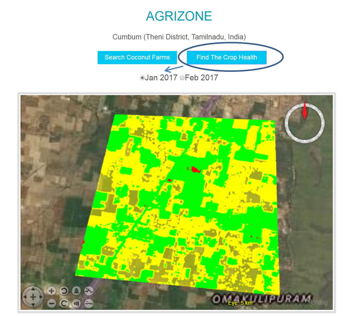
For Crop Health analysis we have used 4-band multispectral satellite imagery (R, G, B, NIR) with pixel size 3m

In the same area where our Deep Learning codes for coconut model has been tested, we show the Vegetation Index for the same Geolocation for the Month of January and February 2017. The vegetation index displayed represents relative chlorophyll content, which correlates with vegetation vigor and productivity. The red tones represent low relative chlorophyll content while the green ones show high relative chlorophyll content.
Our Implementation Shows you can find a Crop (example : coconut crop) based on Deep Learning and use the Multispectral Imagery in the same geolocation to find the Crop Health by using the NASA Worldwind Visualization tools.
Using the power of Deep Learning we can Identify the Coconut crop in Large Geo Location without getting the Boots on the ground, by further integrating the Multispectral Imagery based crop Health analysis, we will come to know which geo location we need to focus and prioritize based on the Crop Identification results. Farmers in those stressfull regions will be advised and helped to manage the crops effectively to increase productivity
The Neural Network was trained using Floydhub's free GPU offering. On average, it took 1 hour for our models, which were roughly 10MB in size.