How to install:
mvn clean install

cd oozie-workflow

./install-workflow.sh dev GITHUB_KEY
This blog post describes the basic algorithm for finding gridded datasets in more detail.
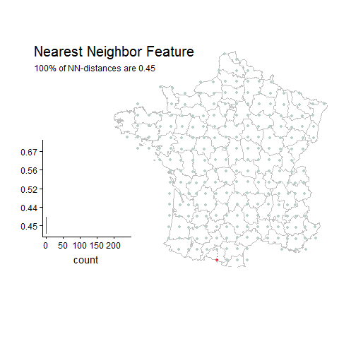
gridded example
not gridded example
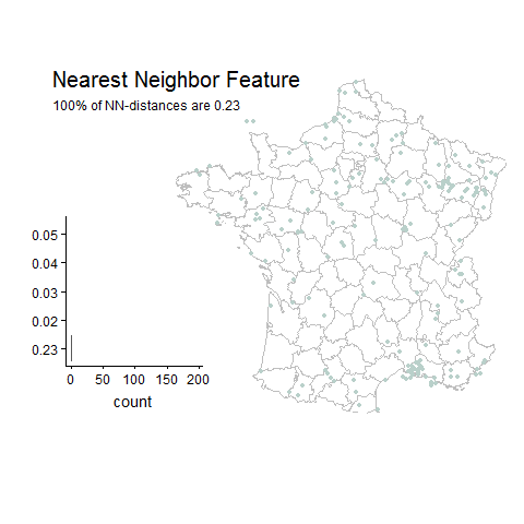
Basically the algorithm searches for gridded datasets by computing one feature: the percent of nearest neighbor distances (euclidean) that are the same.
After this feature is computed the following datasets are classified as gridded:
- Datasets with >20 unique lat-lon points.
- Datasets that have >30% of their unique lat-lon points with the same nearest neighbor distance.
- Datasets with a nearest neighbor distances >0.02 decimal degrees.
This implementation is limited to datasets with <30,000 unique (lat,lon) points. It uses local sensitivity hashing to reduce the NxN search space for nearest neighbor distances. Because of this sometimes datasets on a small grid (approx. < 0.1) with a large amount of unique points (>30,000), will not be found.
Most gridded datasets on GBIF fill in 1 of the 3 following fields (usually with a constant value):
- coordinateUncertainyInMeters
- coordinatePrecision
- footPrintWKT
Since not all gridded dataset publishers fill in these fields, this project acts as a convenient way to identify them.
The end result of the gridded dataset search will produce a table with the following columns:
- totalCount (total_count) : the total number unique lat-lon points in the dataset.
- minDist (min_dist) : the most common nearest neighbor (minimum) distance between unique lat-lon points.
- minDistCount (min_dist_count) : the number of nearest neightbor distances that are equal to the minDist.
- maxPercent (max_percent) : the percentage (fraction 0-1) of unique lat-lon points that have the same nearest neighbor distance.
maxPercent is the main way to identify a "gridded" dataset. If this number is high (> 0.3), then the dataset is considered gridded.