A good visualisation is worth the wait(weight).
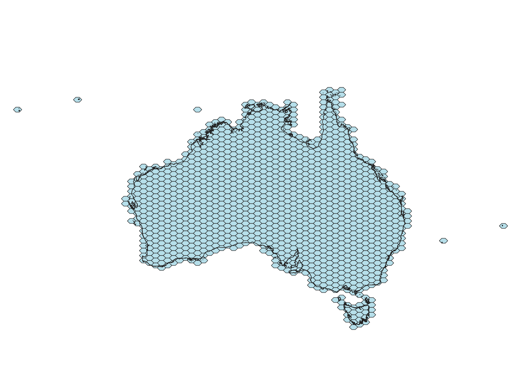 output of polygons.py as png output and reference points for islands added in QGIS
aus_hex_57km_layer
Download Links
- Shapefile Format: ESRI .prj, ESRI .shp , ESRI .shx, ESRI .dbf
- GeoJSON
- KML
- Google Maps (KML) NASA Fires in Australia
Why Wait? The Python approach to cutting out the shape of 'australia' from the derived polygon dataset is not as efficient as using an SQL approach. SQL is efficient but no where near as flexible as Python. If you are not blending region based statistics into the final data set then the 'aus_(hex or box)_(size in km)km_layer' file in kml, geojson and shapefile will meet your needs.
Note: Python joins allow for two islands have added to the map (mapping layer) : Ashmore Reef and Norfolk Island. Complex SQL joins or modification of the base mapping layer are normally required to achieve the same effect.
Proceed to poly_wt.py to add the demographic data of your choice. In this case ABS Statistical Area Level 1 data sets are merged together to mease the 'relative change in need for assistance'.
output of map_me.py
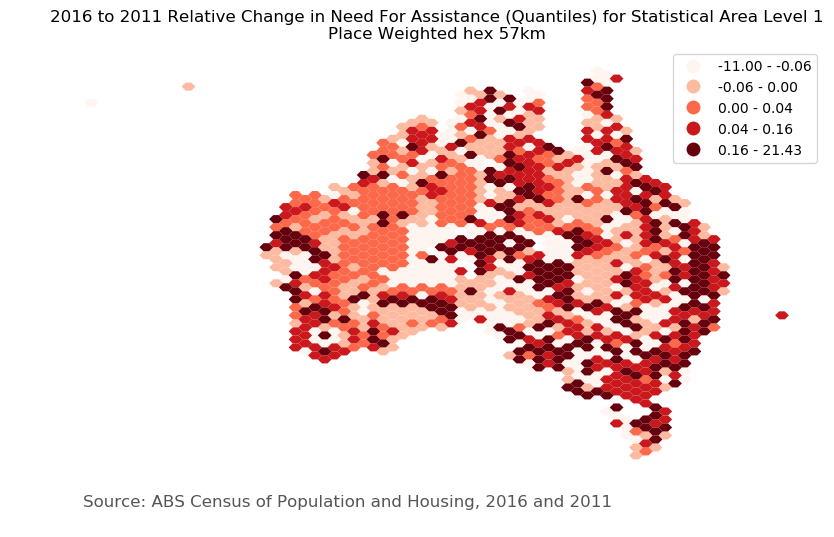
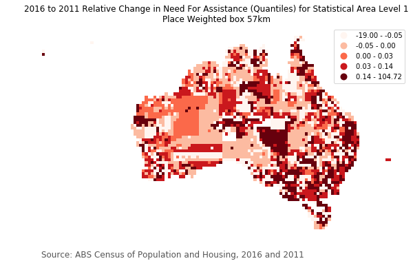
hex_57km_place_11_16 and box_57km_place_11_16
Download Links
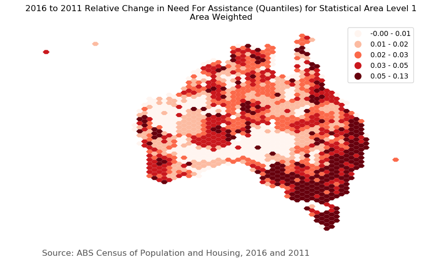
hex_57km_area_11_16 Download Links
- CPython 3.7 for list creation/management and construction of geometric shapes.
- pandas for csv file outputs.
Map Polygons - polgons.py
- geographiclib for WGS84 projection based point calculations for lists.
- geojson for encoding of the geometric shapes.
- matplotlib find points inside polygons used to filter the coastline, and points of interest of the interior.
- pyshp for encoding ESRI shapefiles.
Note: additional operating system libraries are not required for the python modules listed above (Thank you @psmaAaron). This will be useful if your IT department does not support the installation of the proj, geos and GDAL libraries/executables on the operating system. The modulues are built-in to the geopandas module.
Post Processing - poly_wt.py
- pyunpack for downloading and unzipping content from the ABS website.
- GDAL/ogr2ogr for shapefile conversion, simple geometry SQL queries.
- sqlite3 for accessing for spatialite content and processing large tables of tabular content. Note: Operating system libraries are required for GDAL support.
Visulisation - map_me.py
- geopandas, numpy and matplotlib for making really good maps.
- QGIS or your favourite GIS Package.
- You can contribute or make something better
- Have a look in the shapefiles directory for the processed shape files for area weighted and place point of interest weighted files.
Useful Python and R Libraries Choropleths (Thematic mapping) choroplethr (R) pysal (Python)
The Python Code will switch between Linux and Windows Enviromments
For full functionality with Windows OS, download the OSGeo4W package and install the 'express install'. The code will map to the standard installation location on C drive. The code was originally bult for Linux OS. Linux has pretty good package management so no worries here. All python modules are installed using pip3. polygons.py has been tested and works with Linux and Windows.
Download and install with default options the OSGeo4W distriution for Windows
Download the python wheel packages from links for geopandas
- https://www.lfd.uci.edu/~gohlke/pythonlibs/#fiona
- https://www.lfd.uci.edu/~gohlke/pythonlibs/#gdal
- https://www.lfd.uci.edu/~gohlke/pythonlibs/#basemap
Add the PATH variable
- C:\OSGeo4W64\bin
- C:\OSGeo4W64\include
Create/add a GDAL_PATH variable
- C:\OSGeo4W64\share\gdal
to the Windows environment variables for 'PATH' and path c:\OSGeo4W\share\gdal for 'GDAL_PATH' .You can 'pip3 install' your modules. pygeogrids
https://pygeogrids.readthedocs.io/en/v0.1/_rst/pygeogrids.html
R version in development
Not everyone has access to Python so there is an R version of the code with much of the same features. Have a look at polygons2.R. The code is functional in a Windows environment using the OSGeo4W software.
see the end result http://rpubs.com/damien123/506636
This R library is quite nice https://github.com/r-barnes/dggridR and result http://rpubs.com/damien123/506921
Add to the PATH variable
- C:\OSGeo4W64\bin
- C:\OSGeo4W64\include
- C:\Program Files\R\R-3.6.0\bin
Why not use Vendor 'XYZ' or 'ABC' Software?
The processes applied to the datasets would normally be tasked to individual analysts and use software purchased for that purpose. There are software packages that work at a larger scale than the desktop analysis to perform more industrial scale processes. Again there is another set of personnel to achieve perform these tasks. Making the best use of both types of software is a challenge. A task can escalate beyond the capabalilities of desktop software or a task began at the indsutrial scale can become unmanageable.
The list of software is entirely open sourced. The coding and deployement of sub systems where chosen according to each software's ability to perform a given task in set period of time balancing out memory, storage and CPU access requirements. The data could be processed by running a single Python program (currently three) by one person. In an open source environment interoperability of automation, data format and operating system support is assumed.
A process built around purchased software would deliver a dataset output like this one, but it would have to work arounf the constraints of the environment in which the software has been deployed. Vendor purchased software is interoperable with other software from the same vendor at the data and automation level.
Vendor operating systems such as Windows 10 now allows for an instance of the open source Linux operating system to operate on top of a Windows 10 platform. If not there are other options that are less attractive. The Windows Subsystem for Linux (WSL) once enabled allows for a choice of your preferred Linux distribution.The other option is to deploy open source software and sub systems in Windows 10 is to use the OSGeo4W resource.
OSGeo4W is a binary distribution of a broad set of open source geospatial software for Win32 and Win64 environments (Windows XP, Vista, Windows 7, Windows 10). OSGeo4W includes GDAL/OGR, Python3, QGIS, SQLite, as well as many other packages (over 150 as of December 2015). This has dependencies on Windows 10 Developer software for compiling Python libraries and and SQL server runtime software that tends the prevents installation of the software.
polygons.py
This program was an attempt to replicate the Discrete Global Grid System (DGGS) standrd output . In attempting achieve this goal other options were able to explored and a lot of fun had while keeping the desired functionality of the DGGS with the functionality of existing boundary data sets. The polygons cover the same area as the boundary data.
command line arguments are:
- shape - hex or box
- bounding north
- bounding south
- bounding east
- bounding west
- radial in km
- filename for output
for hexagon: python3 polygons.py hex -8 -45 168 96 212 hex_212km
for boxes: python3 polygons.py box -8 -45 168 96 212 box_212km
Why the Weight - Places or Regions
Region data with aggregate data values is represented by summarised from an area defined by a polygon. The majority of administrative boundary data sets small areas areas for high population counts and large areas for small population counts.
For an area weighted correspondence file to a smaller polgons dataset, larger polygon areas with low population counts will mask areas of high values within the polygon. Area weighting is good for land management, associating population density with the feature count. Area weighting takes less time and computer resources, but is more relevant to regions rather than places.
For a population weighted correspondence file to a smaller polgons dataset, larger polygon areas with low population counts will be weighted to where people live within the polygon. Population weights reflect the population criteria with a smaller polygon size that better relates to discrete locations of interest. Population weighting takes more time and computer resources, but is more relevant to places rather than regions.
In this example the number of points of interest (POI) within and between interecting areas is used a proxy for a population weight.
poly_wt.py
This program populate the shapes with demographic and POI based dataset content dor the area weighted analysis and include some of of this data to place weight values in larger overlalapping regions.
map_me.py
Make the really good map at the top of the document.
| Website Source | File | Download | Feature count | File size |
|---|---|---|---|---|
| Australian Bureau of Statistics | AUS_2016_AUST.shp | download link | 1 | |
| SA1_2011_AUST.shp | download link | 54,806 | 174 MB | |
| SA1_2016_AUST.shp | download link | 57,523 | 185.5 MB | |
| 2011Census_B18_AUST_SA1_long.csv | download link | 54,806 | 19 MB | |
| 2011Census_B21_AUST_SA1_long.csv | download link | 54,806 | ||
| 2011Census_B22_AUST_SA1_long.csv | download link | 54,806 | ||
| 2016Census_G18_AUS_SA1.csv | download link | 57,523 | 20 MB | |
| 2016Census_G21_AUS_SA1.csv | download link | 57,523 | ||
| 2016Census_G22_AUS_SA1.csv | download link | 57,523 | ||
| OSMStreetMap (Australia) from geofabrik.de | gis_osm_places_free_1.shp | download_link | ||
| gis_osm_roads_free_1.shp | download_link | |||
| gis_osm_pois_free_1.shp | download_link | |||
| data.gov.au | Australian Government Indigenous Programs & Policy Locations (AGIL) dataset | download_link | ||
| Mobile Black Spot Program Round 4 | download_link |
Polygon shapes are given attributes from data sets with spatial references. The polygon data is processed using scripts with their SQL and vrt file pointing to file names.
For this example, spatial and tabular attribute data have been selected. The content is ABS SA1 2011 and 2016 shapefiles with associated demographic data items. The data was sourced from the the Australian Bureau of Statistics (ABS).
The hexagon or box shapes are created by the polygons.py python program. The features can be points, lines, polygons with or with attributes to be aggrregated into the hexagon or box shapes.
After you have download the files in the table above add data using file_to_db.py: python3.py file_to_db.py or the following bash shell scripts:
(only works with hexagons of 57km at this point time) Performs the functions:
- Filter to coastline
- Feature cut to shape and calculate area weight
- Attrib Data to shape and apply area weight
- Calculate place weights
- Attrib Data to shape and apply place weights
- Make non ABS counts for each shape
- Merge attrib data to area and place weighted shapes
| File | VRT File | SQL File |
|---|---|---|
| polygons.py | ||
| place_wt.py | aust_shape.sql | |
| all.vrt | feat_aust_11.sql | |
| all.vrt | feat_aust_16.sql | |
| tabular_place_wt.txt | ||
| tabular_area_wt.txt | ||
| all.vrt | shape_11_16_area.sql | |
| all.vrt | shape_11_16_place.sql |
| File | Input | Output |
|---|---|---|
| polygons.py | hex_57km_layer.json | hex_57km_layer.shp |
| hex_57km_points.csv | hex_57km_neighbours.csv | |
| place_wt.py | hex_57km_layer.shp | |
| AUS_2016_AUST.shp | aust_hex_shape_57km.shp | |
| SA1_2011_AUST.shp | feat_aust_57km_sa1_11.shp | |
| SA1_2016_AUST.shp | feat_aust_57km_sa1_16.shp | |
| 2011Census_B18_AUST_SA1_long.csv | ||
| 2011Census_B21_AUST_SA1_long.csv | ||
| 2011Census_B22B_AUST_SA1_long.csv | ||
| 2016Census_G18_AUS_SA1.csv | ||
| 2016Census_G21_AUS_SA1.csv | ||
| 2016Census_G22_AUS_SA1.csv | ||
| agil.shp | ||
| gis_osm_places_free_1.shp | ||
| gis_osm_pois_free_1.shp | ||
| gis_osm_roads_free_1.shp | ||
| mbsp_database.csv | ||
| mbsp.shp | ||
| tabular_hex_57km_11_16_area.csv | hex_57km_area_11_16.shp | |
| tabular_hex_57km_place.csv | hex_57km_place_11_16.shp |
*The Australian Bureau of Statistics (ABS) supplies Census demographic to the level to Statistical Area Level 2 (SA2) via a public facing Web API. Statistical Area Level 1 have the most detail and the lowest geographic classification. Truncated CSV files Census data pack tables have been used for this example.
| File | Feature count | File size | Projection (EPSG) |
|---|---|---|---|
| hex_57km_layer.json | 4,051 | 2.4 MB | 4326 |
| hex_57km_layer.shp | 4,051 | 627 KB | 4283 |
| AUS_2016_AUST.shp | 1 | 26.6 MB | 4283 |
| aust_hex_shape_57km.shp | 1,262 | 627 KB | 4283 |
| SA1_2011_AUST.shp | 54,806 | 174 MB | 4283 |
| feat_aust_57km_sa1_11.csv | 59,986 | ||
| SA1_2016_AUST.shp | 57,523 | 185.5 MB | 4283 |
| feat_aust_57km_sa1_11.csv | 62,756 | ||
| 2011Census_B18_AUST_SA1_long.csv | 54,806 | ||
| 2011Census_B21_AUST_SA1_long.csv | 54,806 | ||
| 2011Census_B22B_AUST_SA1_long.csv | 54,806 | ||
| 2016Census_G18_AUS_SA1.csv | 57,523 | ||
| 2016Census_G21_AUS_SA1.csv | 57,523 | ||
| 2016Census_G22B_AUS_SA1.csv | 57,523 | ||
| donor_feat_11_area_B18_B21_B22.csv | 1,262 | ||
| donor_feat_16_area_G18_G21_G22.csv | 1,262 | ||
| donor_feat_11_place_B18_B21_B22.csv | 1,262 | ||
| donor_feat_16_pace_G18_G21_G22.csv | 1,262 | ||
| gis_osm_places_free_1.shp | 4326 | ||
| AGIL.json | 4326 | ||
| agil.shp | 4326 | ||
| gis_osm_pois_free_1.shp | 4326 | ||
| gis_osm_pois_free_1.shp | 4283 | ||
| gis_osm_roads_free_1.shp | 4326 | ||
| mbsp_database.csv | |||
| mbsp.shp | |||
| tabular_57km_11_16_area | |||
| tabular_57km_11_16_place | |||
| hex_57km_area_11_16.shp | 1,262 | 377 KB | 4283 |
| hex_57km_place_11_16.shp | 1,262 | 377 KB | 4283 |
- ASSNP Core Activity Need for Assistance
- UNCAREP Unpaid Assistance to a Person with a Disability
- CHCAREP Unpaid Child Care
Measures the number of people with a profound or severe disability. People with a profound or severe disability are defined as those people needing help or assistance in one or more of the three core activity areas of self-care, mobility and communication, because of a disability, long-term health condition (lasting six months or more) or old age. Applicable to: All persons Categories:
| Code | Description |
|---|---|
| 1 | Has need for assistance with core activities |
| 2 | Does not have need for assistance with core activities |
| & | Not stated |
| V | Overseas visitor |
Number of categories: 4
Records people who in the two weeks prior to Census night spent time providing unpaid care, help or assistance to family members or others because of a disability, a long-term health condition or problems related to old age. This includes people who are in receipt of a Carer Allowance or Carer Payment. It does not include work done through a voluntary organisation or group. Applicable to: Persons aged 15 years and over Categories:
| Code | Description |
|---|---|
| 1 | No unpaid assistance provided |
| 2 | Provided unpaid assistance |
| & | Not stated |
| @ | Not applicable |
| V | Overseas visitor |
- Number of categories: 5
- Not applicable (@) category comprises:
- Persons aged under 15 years
Records people, who in the two weeks prior to Census night, spent time caring for a child/children (under 15 years) without pay. Applicable to: Persons aged 15 years and over Categories:
| Code | Description |
|---|---|
| 1 | Did not provide child care |
| 2 | Cared for own child/children |
| 3 | Cared for other child/children |
| 4 | Cared for own child/children and other child/children |
| & | Not stated |
| @ | Not applicable |
| V | Overseas visitor |
- Number of categories: 7
- Not applicable (@) category comprises:
- Persons aged under 15 years
| 2011 | 2016 | Table Name | count 11 | count 16 | total 11 | total 16 |
|---|---|---|---|---|---|---|
| B18 | G18 | Core Activity Need for Assistance by Age by Sex | NeedA11 | NeedA16 | NeedAT11 | TNeedAT16 |
| B21 | G21 | Unpaid Assistance to a Person with a Disability by Age by Sex | UPunPA11 | UPunP16 | UPunPT11 | UPunPT16 |
| B22B | G22B | Unpaid Child Care by Age by Sex | PUnPCC11 | PUnPCC16 | PUnPCCT11 | PUnPCCT16 |
Health/Child Care
| Year | Profile table | Data Pack file | Short | Long | Column heading description in profile | Type |
|---|---|---|---|---|---|---|
| 2011 | B18 | B18 | P_Tot_Need_for_assistance | Persons_Total_Has_need_for_assistance | Need for assistance | PERSONS |
| P_Tot_No_need_for_assistance | Persons_Total_Does_not_have_need_for_assistance | No need for assistance | PERSONS | |||
| P_Tot_Need_for_assistance_ns | Persons_Total_Need_for_assistance_not_stated | Need for assistance not stated | PERSONS | |||
| P_Tot_Tot | Persons_Total_Total | Total | PERSONS | |||
| B21 | B21 | P_Tot_prvided_unpaid_assist | Persons_Total_Provided_unpaid_assistance | Provided unpaid assistance | PERSONS | |
| P_Tot_No_unpaid_asst_prvided | Persons_Total_No_unpaid_assistance_provided | No unpaid assistance provided | PERSONS | |||
| P_Tot_Unpaid_assist_ns | Persons_Total_Unpaid_assistance_not_stated | Unpaid assistance not stated | PERSONS | |||
| P_Tot_Tot | Persons_Total_Total | Total | PERSONS | |||
| B22B | B22 | P_Tot_CF_Total | Persons_Total_Cared_for_Total | Cared for: Total | PERSONS | |
| P_Tot_DNPCC | Persons_Total_Did_not_provide_child_care | Did not provide child care | PERSONS | |||
| P_Tot_UCC_NS | Persons_Total_Unpaid_child_care_not_stated | Unpaid child care not stated | PERSONS | |||
| P_Tot_Total | Persons_Total_Total | Total | PERSONS | |||
| 2016 | G18 | G18 | P_Tot_Need_for_assistance | Persons_Total_Has_need_for_assistance | Need for assistance | PERSONS |
| P_Tot_No_need_for_assistance | Persons_Total_Does_not_have_need_for_assistance | No need for assistance | PERSONS | |||
| P_Tot_Need_for_assistance_ns | Persons_Total_Need_for_assistance_not_stated | Need for assistance not stated | PERSONS | |||
| P_Tot_Tot | Persons_Total_Total | Total | PERSONS | |||
| G21 | G21 | P_Tot_prvided_unpaid_assist | Persons_Total_Provided_unpaid_assistance | Provided unpaid assistance | PERSONS | |
| P_Tot_No_unpaid_asst_prvided | Persons_Total_No_unpaid_assistance_provided | No unpaid assistance provided | PERSONS | |||
| P_Tot_Unpaid_assist_ns | Persons_Total_Unpaid_assistance_not_stated | Unpaid assistance not stated | PERSONS | |||
| P_Tot_Tot | Persons_Total_Total | Total | PERSONS | |||
| G22B | G22 | P_Tot_CF_Total | Persons_Total_Cared_for_Total | Cared for: Total | PERSONS | |
| P_Tot_DNPCC | Persons_Total_Did_not_provide_child_care | Did not provide child care | PERSONS | |||
| P_Tot_UCC_NS | Persons_Total_Unpaid_child_care_not_stated | Unpaid child care not stated | PERSONS | |||
| P_Tot_Total | Persons_Total_Total | Total | PERSONS |
Education
| Year | Profile table | Data Pack file | Short | Long | Column heading description in profile | Type |
|---|---|---|---|---|---|---|
| 2011 | B40 | B40 | Non_sch_quals_PostGrad_Dgre_P | Non_school_qualifications_Postgraduate_Degree_Level_Persons | Postgraduate Degree Level | PERSONS |
| Non_sch_quals_Gr_Dip_Gr_Crt_P | Non_school_qualifications_Graduate_Diploma_and_Graduate_Certificate_Level_Persons | Graduate Diploma and Graduate Certificate Level | PERSONS | |||
| Non_sch_quals_Bchelr_Degree_P | Non_school_qualifications_Bachelor_Degree_Level_Persons | Bachelor Degree Level | PERSONS | |||
| Non_sch_quls_Advncd_Dip_Dip_P | Non_school_qualifications_Advanced_Diploma_and_Diploma_Level_Persons | Advanced Diploma and Diploma Level | PERSONS | |||
| Non_sch_quls_Cert3a4_Level_P | Non_school_qualifications_Certificate_Level_Certificate_III_and_IV_Level_Persons | Certificate III & IV Level | PERSONS | |||
| Non_sch_quls_Cert1a2_Level_P | Non_school_qualifications_Certificate_Level_Certificate_I_and_II_Level_Persons | Certificate I & II Level | PERSONS | |||
| Non_sch_quls_Certnfd_Level_P | Non_school_qualifications_Certificate_Level_Certificate_Level_nfd_Persons | Certificate Level, nfd | PERSONS | |||
| Non_sch_quls_CertTot_Level_P | Non_school_qualifications_Certificate_Level_Total_Persons | Total | PERSONS | |||
| 2016 | G40 | G40 | Non_sch_quals_PostGrad_Dgre_P | Non_school_qualifications_Postgraduate_Degree_Level_Persons | Postgraduate Degree Level | PERSONS |
| Non_sch_quals_Gr_Dip_Gr_Crt_P | Non_school_qualifications_Graduate_Diploma_and_Graduate_Certificate_Level_Persons | Graduate Diploma and Graduate Certificate Level | PERSONS | |||
| Non_sch_quals_Bchelr_Degree_P | Non_school_qualifications_Bachelor_Degree_Level_Persons | Bachelor Degree Level | PERSONS | |||
| Non_sch_quls_Advncd_Dip_Dip_P | Non_school_qualifications_Advanced_Diploma_and_Diploma_Level_Persons | Advanced Diploma and Diploma Level | PERSONS | |||
| Non_sch_quls_Cert3a4_Level_P | Non_school_qualifications_Certificate_Level_Certificate_III_and_IV_Level_Persons | Certificate III & IV Level | PERSONS | |||
| Non_sch_quls_Cert1a2_Level_P | Non_school_qualifications_Certificate_Level_Certificate_I_and_II_Level_Persons | Certificate I & II Level | PERSONS | |||
| Non_sch_quls_Certnfd_Level_P | Non_school_qualifications_Certificate_Level_Certificate_Level_nfd_Persons | Certificate Level, nfd | PERSONS | |||
| Non_sch_quls_CertTot_Level_P | Non_school_qualifications_Certificate_Level_Total_Persons | Total | PERSONS |
Housing
| Year | Profile table | Data Pack file | Short | Long | Column heading description in profile | Type |
|---|---|---|---|---|---|---|
| 2011 | B32 | B32 | OPDs_Separate_house_Dwellings | Occupied_private_dwellings_Separate_house_Dwellings | Separate house | DWELLINGS |
| Total OPDs_SD_r_t_h_th_Tot_Dwgs | Occupied_private_dwellings_Semi_detached_row_or_terrace_house_townhouse_etc_with_Total_Dwellings | Semi-detached, row or terrace house, townhouse etc. | DWELLINGS | |||
| OPDs_Flt_apart_Tot_Dwgs | Persons_Total_Need_for_assistance_not_stated | Flat or apartment | DWELLINGS | |||
| OPDs_Other_dwelling_Tot_Dwgs | Occupied_private_dwellings_Other_dwelling_Total_Dwellings | Other dwelling | DWELLINGS | |||
| OPDs_Dwlling_structur_NS_Dwgs | Occupied_private_dwellings_Dwelling_structure_not_stated_Dwellings | Dwelling structure not stated | DWELLINGS | |||
| Total_PDs_Dwellings | Total_private_dwellings_Dwellings | Total occupied private dwellings | DWELLINGS | |||
| Unoccupied_PDs_Dwgs | Unoccupied_private_dwellings_Dwellings | Unoccupied private dwellings | DWELLINGS | |||
| OPDs_Tot_OPDs_Dwellings | Occupied_private_dwellings_Total_occupied_private_dwellings_Dwellings | DWELLINGS | ||||
| B33 | B33 | R_RE_Agt_Total | Rented_Real_Estate_Agent_Total | Real estate agent | DWELLINGS | |
| R_ST_h_auth_Total | Rented_State_or_territory_housing_authority_Total | State or territory housing authority | DWELLINGS | |||
| R_Psn_not_in_s_hh_Total | Rented_Person_not_in_same_household_Total | Person not in same household | DWELLINGS | |||
| R_Hse_coop_cty_ch_gp_Total | Rented_Housing_co_operative_community_church_group_Total | Housing co-operative/community/church group | DWELLINGS | |||
| R_Ot_landld_typ_Total | Rented_Other_landlord_type_Total | Other landlord type | DWELLINGS | |||
| R_Landld_typ_NS_Total | Rented_Landlord_type_not_stated_Total | Landlord type not stated | DWELLINGS | |||
| 2016 | G32 | G32 | OPDs_Separate_house_Dwellings | Occupied_private_dwellings_Separate_house_Dwellings | Separate house | DWELLINGS |
| Total OPDs_SD_r_t_h_th_Tot_Dwgs | Occupied_private_dwellings_Semi_detached_row_or_terrace_house_townhouse_etc_with_Total_Dwellings | Semi-detached, row or terrace house, townhouse etc. | DWELLINGS | |||
| OPDs_Flt_apart_Tot_Dwgs | Persons_Total_Need_for_assistance_not_stated | Flat or apartment | DWELLINGS | |||
| OPDs_Other_dwelling_Tot_Dwgs | Occupied_private_dwellings_Other_dwelling_Total_Dwellings | Other dwelling | DWELLINGS | |||
| OPDs_Dwlling_structur_NS_Dwgs | Occupied_private_dwellings_Dwelling_structure_not_stated_Dwellings | Dwelling structure not stated | DWELLINGS | |||
| Total_PDs_Dwellings | Total_private_dwellings_Dwellings | Total occupied private dwellings | DWELLINGS | |||
| Unoccupied_PDs_Dwgs | Unoccupied_private_dwellings_Dwellings | Unoccupied private dwellings | DWELLINGS | |||
| OPDs_Tot_OPDs_Dwellings | Occupied_private_dwellings_Total_occupied_private_dwellings_Dwellings | DWELLINGS | ||||
| G33 | G33 | R_RE_Agt_Total | Rented_Real_Estate_Agent_Total | Real estate agent | DWELLINGS | |
| R_ST_h_auth_Total | Rented_State_or_territory_housing_authority_Total | State or territory housing authority | DWELLINGS | |||
| R_Psn_not_in_s_hh_Total | Rented_Person_not_in_same_household_Total | Person not in same household | DWELLINGS | |||
| R_Hse_coop_cty_ch_gp_Total | Rented_Housing_co_operative_community_church_group_Total | Housing co-operative/community/church group | DWELLINGS | |||
| R_Ot_landld_typ_Total | Rented_Other_landlord_type_Total | Other landlord type | DWELLINGS | |||
| R_Landld_typ_NS_Total | Rented_Landlord_type_not_stated_Total | Landlord type not stated | DWELLINGS |
Employment
| Year | Profile table | Data Pack file | Short | Long | Column heading description in profile | Type |
|---|---|---|---|---|---|---|
| 2011 | B40 | B40 | lfs_Tot_LF_P | Labour_force_status_Total_labour_force_Persons | Total labour force | PERSONS |
| lfs_N_the_labour_force_P | Labour_force_status_Not_in_the_labour_force_Persons | Not in the labour force | PERSONS | |||
| Percent_Unemployment_P | Labour_force_status_Percent_Unemployment_Persons | % Unemployment | PERSONS | |||
| Non_sch_quls_Advncd_Dip_Dip_P | Non_school_qualifications_Advanced_Diploma_and_Diploma_Level_Persons | Advanced Diploma and Diploma Level | PERSONS | |||
| Percnt_LabForc_prticipation_P | Labour_force_status_Percent_Labour_force_participation_Persons | % Labour force participation | PERSONS | |||
| Percnt_Employment_to_populn_P | Labour_force_status_Percent_Employment_to_population_Persons | % Employment to population | PERSONS | |||
| B43 | B43b | Persons_Employed_worked_Full_time_Total | Full-time | PERSONS | ||
| P_Emp_PartT_Tot | Persons_Employed_worked_Part_time_Total | Part-time | PERSONS | |||
| P_Hours_wkd_NS_Tot | Persons_Hours_worked_not_stated_Total | Hours worked not stated | PERSONS | |||
| P_Tot_Emp_Tot | Persons_Total_employed_Total | Total employed | PERSONS | |||
| P_Unem_look_FTW_Tot | Persons_Unemployed_looking_for_Full_time_work_Total | Full-time work | PERSONS | |||
| P_Unem_look_PTW_Tot | Persons_Unemployed_looking_for_Part_time_work_Total | Part-time work | PERSONS | |||
| P_Tot_Unemp_Tot | Persons_Total_unemployed_Total | Total unemployed | PERSONS | |||
| P_Tot_Emp_Tot | Persons_Total_employed_Total | Total employed | PERSONS | |||
| P_LFS_NS_Tot | Persons_Labour_force_status_not_stated_Total | Total labour force not stated | PERSONS | |||
| P_Not_in_LF_Tot | Persons_Not_in_the_labour_force_Total | Not in the labour force | PERSONS | |||
| 2016 | G40 | G40 | lfs_Tot_LF_P | Labour_force_status_Total_labour_force_Persons | Total labour force | PERSONS |
| lfs_N_the_labour_force_P | Labour_force_status_Not_in_the_labour_force_Persons | Not in the labour force | PERSONS | |||
| Percent_Unem_loyment_P | Labour_force_status_Percent_Unemployment_Persons | % Unemployment | PERSONS | |||
| Non_sch_quls_Advncd_Dip_Dip_P | Non_school_qualifications_Advanced_Diploma_and_Diploma_Level_Persons | Advanced Diploma and Diploma Level | PERSONS | |||
| Percnt_LabForc_prticipation_P | Labour_force_status_Percent_Labour_force_participation_Persons | % Labour force participation | PERSONS | |||
| Percnt_Employment_to_populn_P | Labour_force_status_Percent_Employment_to_population_Persons | % Employment to population | PERSONS | |||
| G43 | G43b | Persons_Employed_worked_Full_time_Total | Full-time | PERSONS | ||
| P_Emp_PartT_Tot | Persons_Employed_worked_Part_time_Total | Part-time | PERSONS | |||
| P_Hours_wkd_NS_Tot | Persons_Hours_worked_not_stated_Total | Hours worked not stated | PERSONS | |||
| P_Tot_Emp_Tot | Persons_Total_employed_Total | Total employed | PERSONS | |||
| P_Unem_look_FTW_Tot | Persons_Unemployed_looking_for_Full_time_work_Total | Full-time work | PERSONS | |||
| P_Unem_look_PTW_Tot | Persons_Unemployed_looking_for_Part_time_work_Total | Part-time work | PERSONS | |||
| P_Tot_Unemp_Tot | Persons_Total_unemployed_Total | Total unemployed | PERSONS | |||
| P_Tot_Emp_Tot | Persons_Total_employed_Total | Total employed | PERSONS | |||
| P_LFS_NS_Tot | Persons_Labour_force_status_not_stated_Total | Total labour force not stated | PERSONS | |||
| P_Not_in_LF_Tot | Persons_Not_in_the_labour_force_Total | Not in the labour force | PERSONS |
If you have read down to this point in the documemtation then you can see the end result is worth the wait. The benefits of using a Discrete Global Grid System (DGGC) like visualisation is better on the eye once you see it for yourself. But this depends on how your data is made and how fast you want it made. If your data is like this then a traditional SQL server will do just fine, with a bit of extra work. You will have access to all of the viewing and map production software that the current generation of software going back to the 1990s will provide.
Larger volumes of data and newer SPARQL/GeoSPARQL and Discrete Global Grid System (DGGC) enabled systems and and data sets provide a much better end product for the real users of this data. Not the Geospatial Anaysts, statistcians but the people who benefit from decisions informed from data.
Further Reading
- http://redblobgames.com/grids/hexagons
- https://geoawesomeness.com/discrete-global-grid-system-dggs-new-reference-system/
- https://wiki.openstreetmap.org/wiki/Australian_data_catalogue
To finish things off it would be nice to be able to run multiple instances of the same code to process all of the different data sources and visualisation requirements. Containerisation allows for all of this to happen.
Class and method conversion of Python code. see polygons.py, poly_wt.py, map_me.py and isotiles directory for work on 'pythonisation' (classes) of polygons,py code to allow for Docker and API use cases. Fixed some buggy SQL code for area weighted calculations.
PostGIS PostgreSQL/Postgis does some really good things with spatial data and ogr2ogr handles the Nerd (DDL) content issues.
Docker/Containerisation
Rebuilding the Python and SQLITE code around the Docker environment makes the code portable and usable in a production environment.