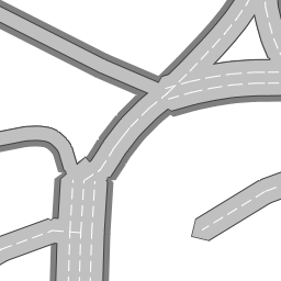
A tile renderer for OpenStreetMap that provides the following tile sets:
- Road overlay
A live version is running at https://osm-tiles.james-ross.co.uk/.
This tile set is an overlay (meaning the tiles are transparent where there is no data) which renders roads (highways) from OpenStreetMap according to their various tags, including:
cycleway=lane =oppositecycleway:left=lanecycleway:right=lanehighway=motorway =trunk =primary =secondary =tertiary =unclassified =residential =service =motorway_link =trunk_link =primary_link =secondary_link =tertiary_linklanes=*oneway=yesparking:lanes:both=parallel =diagonal =perpendicularparking:lanes:left=parallel =diagonal =perpendicularparking:lanes:right=parallel =diagonal =perpendicular
- Only
layer=0or!layerways are rendered for now. - Only zoom levels 16 through 22 are supported.
- Each tile is rendered on-demand, but the underlying data is cached in memory in zoom level 14 chunks.
- Separation and correction of way end nodes at junctions (to align lanes)
- Calculations for
layer!=0, bridges, tunnels - Calculations for bus, PSV (public service vehicle), other specialised lanes
- Calculations for
placement=* - Calculations using turn lane markings
- Calculations for
width - Display tapering of road width/lanes
- Display parking lanes/bays
- Display bridges, tunnels
- Display bus, PSV, other specialised lanes
- Display turn lane markings (left/right turn arrows, etc.)
