Rainey Aberle, Ellyn Enderlin, HP Marshall, Shad O'Neel, & Alejandro Flores
Department of Geosciences, Boise State University
Workflow for detecting glacier snow-covered area, accumulation area ratios, and seasonal snowlines in Sentinel-2, Landsat 8/9, and PlanetScope 4-band imagery.
Basic image processing workflow:
- Google Earth Engine account to access Landsat and Sentinel-2 imagery. Sign up here.
- (Optional) Planet account (sign up here) with access to PlanetScope imagery through the NASA Commercial SmallSat Data Acquisition program (apply here). It may take time for your account to be approved for free PlanetScope images access.
- Shapefile containing a polygon of your area of interest (AOI). This is used for querying imagery from Google Earth Engine and/or Planet Labs, Inc. and cropping images before classifying.
- (Optional) Digital elevation model (DEM). If you do not specify a DEM, the code will automatically use the ArcticDEM Mosaic where there is coverage and the NASADEM otherwise, accessed through the GEE data repository.
Please see the Installation Instructions.
Please see the Basic Workflow Instructions.
Aberle, R., Enderlin, E., O'Neel, S., Marshall., H.P., Florentine, C., Sass, L., and Dickson, A. (in prep) Automated snow cover detection on mountain glaciers using space-borne imagery.
DOI via Zenodo for this GitHub repository coming soon, upon acceptance of manuscript.
Rainey Aberle (raineyaberle@u.boisestate.edu)
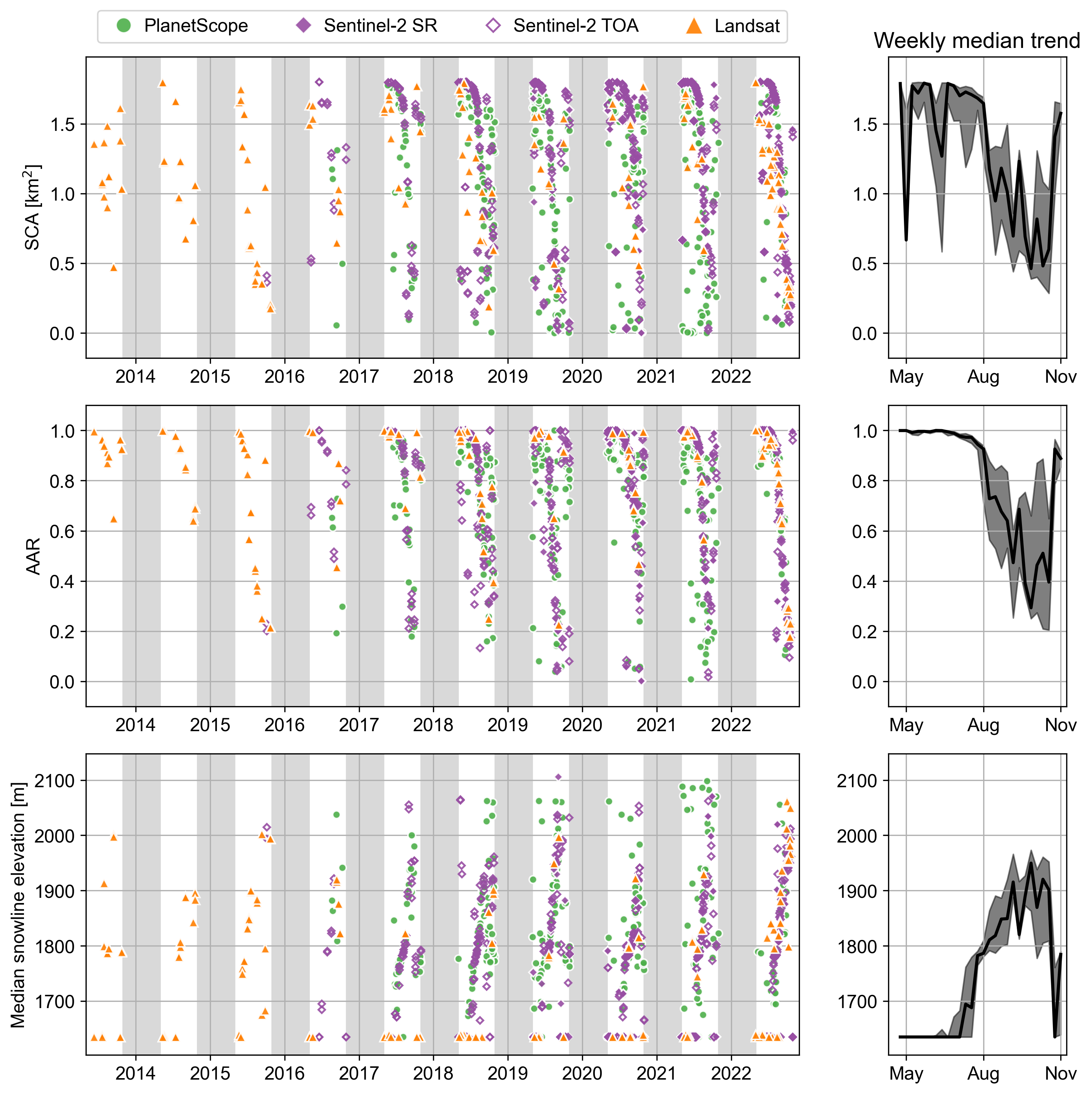
Below are an example time series of snow-covered area (SCA), accumulation area ratio (AAR), and median snowline elevations at South Cascade Glacier, Washington state for 2013-2022.
Classified images and seasonal snowlines
Snow cover metrics time series and weekly median trends
Weekly median trends are excluding PlanetScope to mitigate noise.
We would like to thank members of the CryoGARS Glaciology lab at Boise State University and the USGS Benchmark Glacier program staff for their support and input. This work was funded by BAA-CRREL award W913E520C0017 and NASA EPSCoR award 80NSSC20M0222 and utilized data from Planet Labs, Inc. which was made available through the NASA Commercial Smallsat Data Acquisition (CSDA) Program.
Several open packages made the integration of this Python-based workflow with Google Earth Engine possible. Thank you to the developers of geemap, geedim, and wxee.


