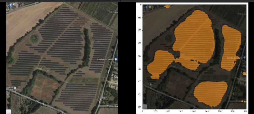
- Estimating the total capacity of a solar site from imagery is a common and challenging task.
- The approach taken here is based on semantic segmentation of the site into panels and non-panels to obtain an estimate of total panel surface area.
- Recent advances in transformer-based segmentation models allow us to have few-shot learning capabilities, which is useful for this task due to the scarcity of annotated data. We therefore use a pre-trained SegNet transformer (https://arxiv.org/abs/1511.00561) and fine-tune it on a small dataset of annotated images obtained from a public research initiative.
- Additionally, due to the expensive nature of acquiring satellite imagery, workflows should be able to leverage open datasets such as google maps imagery. Our results show that we can apply few-shot learning to this task and generalize to unseen lower-resolution imagery.
-
Images for fine-tuning on sites in various environments can be found at https://zenodo.org/record/5171712
-
The following categories of site environments are available:
  - Cropland
  - Grassland
  - Saline/Alkali
  - Shrubwood
  - Water surface
  - Rooftop
- Dataset was produced for public use courtesy of Jiang Hou, Yao Ling, & Liu Yujun. (Multi-resolution dataset for photovoltaic panel segmentation from satellite and aerial imagery 2021)
- In order to run the training procedure:
- Download the portion of the dataset you wish to use for fine-tuning and set the location to the environment variable
IMAGE_FOLDER_PATH - Run
python train.pyto begin training. The model will checkpoints will be saved in the parent directory.
- Download the portion of the dataset you wish to use for fine-tuning and set the location to the environment variable
- To run inference, run
MODEL_CHKPT=<path to model checkpoint> TEST_IMAGEPATH=<path to test image> python inference.py
