this is the manifest v3 port of the extension https://github.com/limex/OpenSwitchMaps running under manifest v2. Currently this repo is NOT WORKING.
If you want to assist, please do so as the code is currently bitching. It is not just changing some simple settings.
Map service switcher for Chrome/Firefox extension
Greatly contributed by jazzzz.
This is a fork from . Kudos for the great work!! Thanks! A very good foundation for my fork!
- Some cleanup done. Added new maps
- Most of the maps didn't calculate the lat/lon/zoom calculation that is needed to open a new map from.
- Chanced the Categories, because some grew to big, while others remained small.
- Switched behavour in the Map Popup: Left Click now opens in new Tab, Middle Click opens in same Tab
- Sorted the Maps by Name
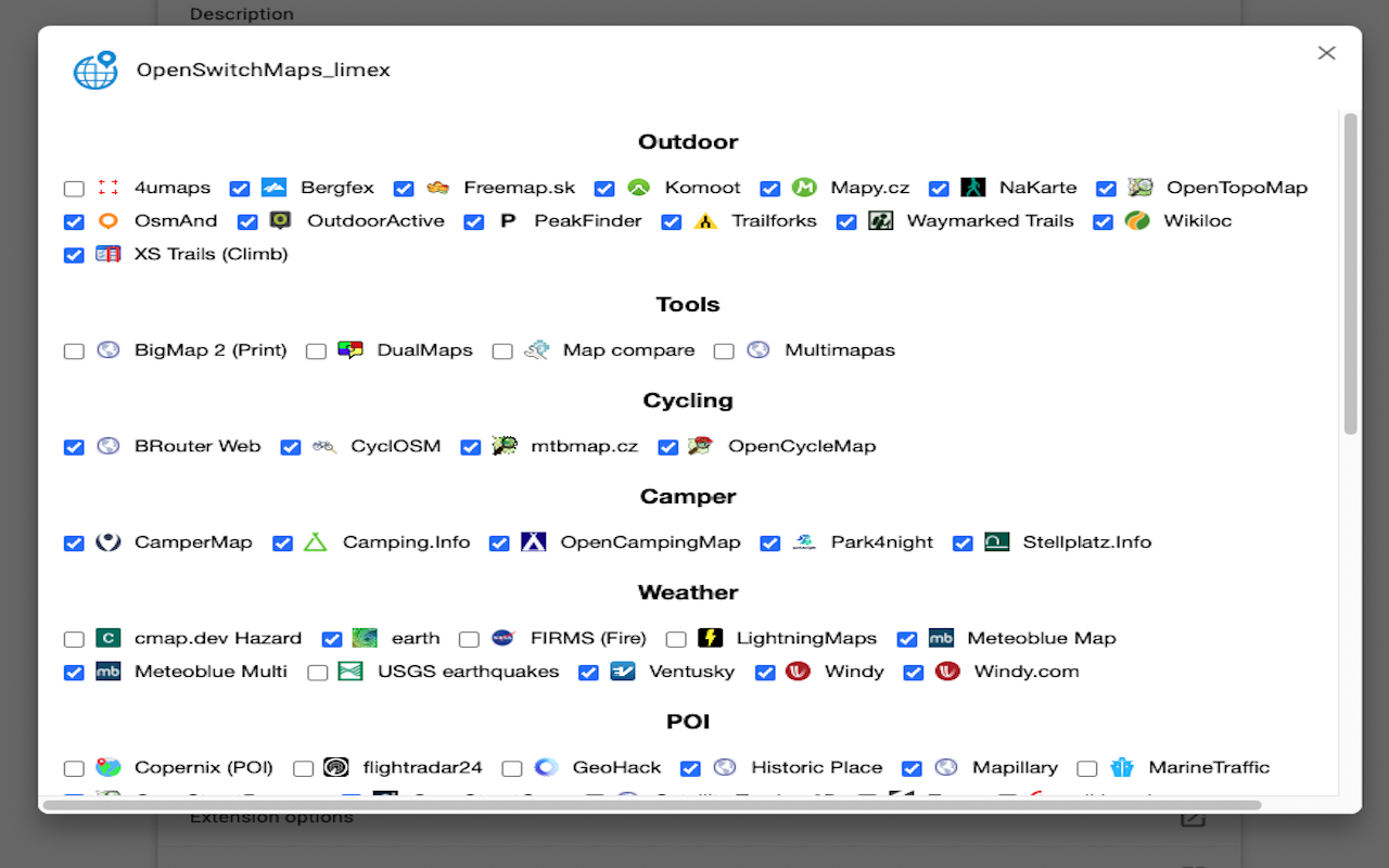
- Show Descriptions while MouseOver in Options Popup
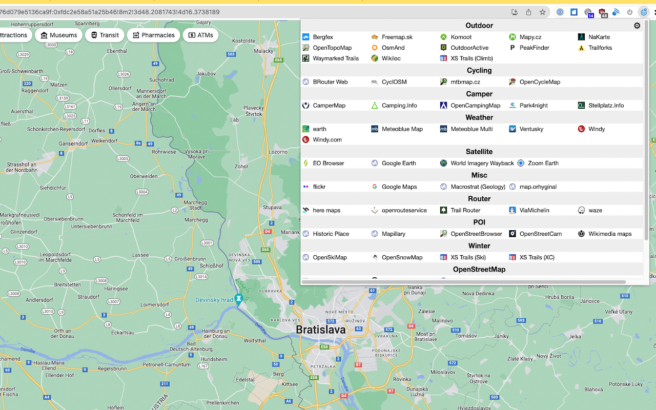
- Existing Extension was listing the Categories in Columns. This limited the number of Categories. Also was a waste of space with smaller Categories. Solution: Render Categories in rows
you have 3 options ...
- (sorry this is outdated, because updating to Marketplace is an time expensive manual task I'm currently not willing to do) Chrome webstore
- (also outdated) Firefox addon center
- Opening the Dialogs on first click take some seconds to show up. Be patient. :)
This extention uses Node.js
-
Install Node.js
-
Install the dependencies: npm install
-
Build the extension: npm run build
-
The extension is built in the
distdirectory -
Add to your Chrome/Firefox
- Chrome: chrome://extensions/ -> Load unpacked
-
Optional:
Increase the build version before 'Build the extension' in Powershell (if needed):
- Set-ExecutionPolicy -ExecutionPolicy RemoteSigned -Scope Process (optional in case of security warning)
- .\inc_patch.ps1
- Download the /dist Directory from github (Clone the Code or Code -> Download ZIP) to a Directory of of your choice
- Add to your Chrome/Firefox
- Chrome: chrome://extensions/ -> Load unpacked
- Open Google map, for example (https://www.google.de/maps/place/Vienna/@48.2092464,16.850411,11z)
- You will see an earth icon near URL bar. Click it.
- Select OpenStreetMap, for example.
- You can jump to OpenStreetMap at the same position
- Left click: Open in a new tab. Middle click: Open the same tab.
Show/hide maps:
- Right click the earth icon,
- Select "Options"
- It might take some seconds for the popup to apear. Collecting all the data takes some time.
- Check/uncheck each map to show/hide it.
- ??
- 4umaps: Topo, Trail difficulty; Outdoor
- Bergfex: Topo, Tracks, Tourism; Outdoor
- BigMap 2 (Print): Obtain a composed big map image; Tools
- BRouter Web: Misc Maps, Custom Layer Overpass & XYZ; Cycling
- CamperMap: Camper POIs; Camper
- Camping.Info: like Stellplatz.info; Camper
- cmap.dev Hazard: Realtime disaster damage estimation; Weather
- Copernix (POI): Show POIs from Wikipedia; POI
- CyclOSM: for Cyclists; Cycling
- DualMaps: synchronized Maps, Aerial & Street View; Tools
- earth: Wind, Ocean, Chem, Particulates; Weather
- EO Browser: Satellite sensing image viewer; Satellite
- FIRMS (Fire): Realtime fire information of satellite observation; Weather
- flickr: Geotagged image search; Misc
- flightradar24: Airplane tracker; POI
- Freemap.sk: Map and Features for Sk; Outdoor
- GeoHack: Map links for Wikipedia articles; POI
- Google Earth: undefined; Satellite
- Google Maps: undefined; Misc
- here maps: undefined; Router
- Historic Place: Historic objects; POI
- KeepRight: OpenStreetMap QA tool; OpenStreetMap
- Komoot: Discover & Plan for multiple Sports; Outdoor
- Kontur: See most active OSM contributor; OpenStreetMap
- Latest OSM Edits per Tile: Latest OpenStreetMap Edits per Tile; OpenStreetMap
- Launch RapiD editor: Facebook AI assisted OSM editor; OpenStreetMap
- Level0 Editor: low-level OSM Editor; OpenStreetMap
- LightningMaps: Realtime lightning map; Weather
- Macrostrat (Geology): Geological map; Misc
- Map compare: Compare maps side-by-side; Tools
- map.orhyginal: Portal of many map services; Misc
- Mapillary: Crowdsourced street-level imagery available as CC BY-SA; POI
- Mapy.cz: Outdoor with geotagged Pics; Outdoor
- MarineTraffic: Ship tracker; POI
- Meteoblue Map: 7d Forecast, Maps Wind, Snow, Waves, Rain, ...; Weather
- Meteoblue Multi: Multi Model 7d Forecast; Weather
- mtbmap.cz: Mountain Bike Map; Cycling
- Multimapas: Compare maps by overlay; Tools
- NaKarte: Heatmaps, Panorama, Streetview, ...; Outdoor
- Old maps online: undefined; Misc
- Open Infrastructure: World's hidden infrastructure (Train, Power, Mobile, ...); Misc
- OpenAerialMap: undefined; Satellite
- OpenCampingMap: Camping Sites; Camper
- OpenCycleMap: Cycling map; Cycling
- OpenGeofiction: Crowdsoured fictional map; Misc
- OpenHistoricalMap: Crowedsourced Historical map; Misc
- OpenRailwayMap: undefined; Misc
- openrouteservice: undefined; Router
- OpenSeaMap: focus on nautical info; Misc
- OpenSkiMap: Ski Slopes, Nordic Ski Trails; Winter
- OpenSnowMap: Winter sports map; Winter
- OpenStreetBrowser: OSM POI viewer; POI
- OpenStreetCam: Crowdsourced street-level imagery available as CC BY-SA; POI
- OpenStreetMap: undefined; OpenStreetMap
- OpenStreetMap Analytics: Analyse when/who edited the OSM data in a specific region; OpenStreetMap
- OpenTopoMap: undefined; Outdoor
- OSM Buildings: undefined; Misc
- OSM Inspector: OpenStreetMap QA tool; OpenStreetMap
- OsmAnd: ; Outdoor
- Osmose: OSM QA tool; OpenStreetMap
- OutdoorActive: Tours for multiple Sports; Outdoor
- Overpass-turbo: Power search tool for OpenStreetMap data; OpenStreetMap
- Park4night: Discover Overnight Parking; Camper
- PeakFinder: Mountain landscape view map; Outdoor
- Satellite Tracker 3D: Satellite tracker; POI
- Sea Beacons: Lighthouse map; Misc
- Stellplatz.Info: like Camping.info App; Camper
- Trail Router: Quick Outdoor Roundtrips; Router
- Trailforks: Outdoor Sport Trails; Outdoor
- Traze: Train tracker; POI
- Twitter: Twitter location based search; Misc
- USGS earthquakes: Latest earthquakes; Weather
- Ventusky: Weather, Wind, Snow, Waves, Rain, ...; Weather
- ViaMichelin: Michelin Travel map; Router
- Waymarked Trails: Show hiking, cycling, ski routes; Outdoor
- waze: Crowdsourced route navigation map; Router
- Who did it?: OpenStreetMap QA tool; OpenStreetMap
- Wikiloc: Trail & Waypoint Community; Outdoor
- wikimapia: multilingual open-content collaborative map; POI
- Wikimedia maps: undefined; POI
- Windy: WebCams on WeatherMap; Weather
- Windy.com: Wind, Ocean, Chem, Particulates; Weather
- World Imagery Wayback: Historic satellite images since 2014; Satellite
- XS Trails (Climb): Rock Climbing; Outdoor
- XS Trails (Ski): Backcountry Ski Mountaineering; Winter
- XS Trails (XC): Cross Country Skiing; Winter
- yelp: Local reviews; POI
- Zoom Earth: Daily Sat Images; Satellite
- ÖPNVKarte: Public transport map; Misc
- MapJumper Plus, by Tomas Kafka
- Maps URL Converter, by lamphanviet.com
- Mapswitch, by evgeny.ger
- Map Switcher, by david.r.edgar
- Map Helper, by petrovnn
- MapSwitcher, by František Nesveda

