• Methodology • GEE Code Availability • Example
Google Earth Engine (GEE) is a cloud-based platform that allows users to have an easy access to a petabyte-scale archive of remote sensing data and run geospatial analysis on Google's infrastructure. The present work developed a function in Google Earth Engine to calculate the TVDI index based on the paper L. W. Schirmbeck et al., 2018.
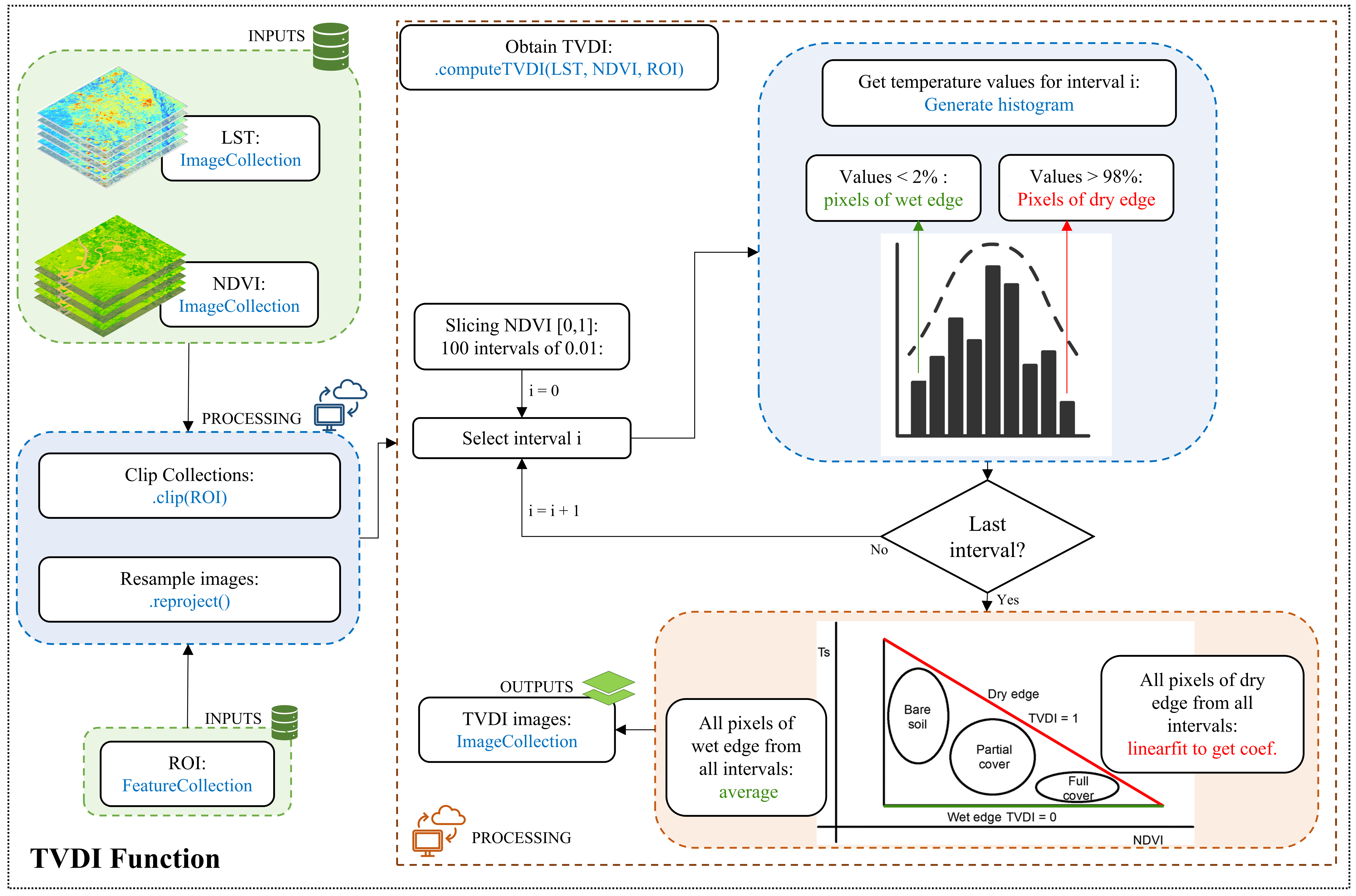
The methodology used in this work was the same used in the paper written by Lucimara Wolfarth Schirmbeck, Denise Cybis Fontana and Juliano Schirmbeck called Two approaches to calculate TVDI in humid subtropical climate of southern Brazil, published in 2018. This methodology briefly consists of the following steps:
- Slice the NDVI values into 100 intervals of 0.01 and obtain the LST values for each of these intervals;
- Construct the cumulative frequency histogram for each NDVI interval and identify the LST values corresponding to 2% and 98% occurrence;
- Define the pixels of the wet edge (all pixels with LST < temperature corresponding to 2%) and the dry edge (all pixels with LST ≥ temperature corresponding to 98%). This procedure was performed for each of the 100 NDVI intervals;
- Group the pixels of each boundary and interval;
- Calculate the dry edge - Linear regression using all pixels that compose the dry edge to obtain the coefficients a and b of the fitted equation;
- Calculate the wet edge - Average value of all pixels that compose the wet edge;
The source code is available in this GitHub repository as well as in the GEE repository, where you can run the example code directly in the interface. To access the repository, use the following link:
https://code.earthengine.google.com/?accept_repo=users/luanabeckerdaluz/TVDIalgorithm
The TVDI processing can be executed by using two main functions. One of them is used to generate the TVDI based on only one NDVI and one LST image (singleTVDI), and the other function is used to generate the TVDI for several NDVI and several LST images (collectionTVDI).
var ROI = ee.Geometry(...)
var imageNDVI = ee.Image(...)
var imageLST = ee.Image(...)
var SCALE_M_PX = CONST
var DEBUG_FLAG = false

// Import TVDI processing module
var computeTVDI = require('users/luanabeckerdaluz/TVDIalgorithm:computeTVDI')

// Compute TVDI
var imageTVDI = computeTVDI.singleTVDI(
  imageNDVI,
  imageLST,
  ROI,
  SCALE_M_PX,
  DEBUG_FLAG
)var ROI = ee.Geometry(...)
var imageCollectionNDVI = ee.ImageCollection(...)
var imageCollectionLST = ee.ImageCollection(...)
var SCALE_M_PX = CONST
// Import TVDI processing module
var computeTVDI = require('users/luanabeckerdaluz/TVDIalgorithm:computeTVDI')
// Compute TVDI
var imageCollectionTVDI = computeTVDI.collectionTVDI(
imageCollectionNDVI,
imageCollectionLST,
ROI,
SCALE_M_PX
)

