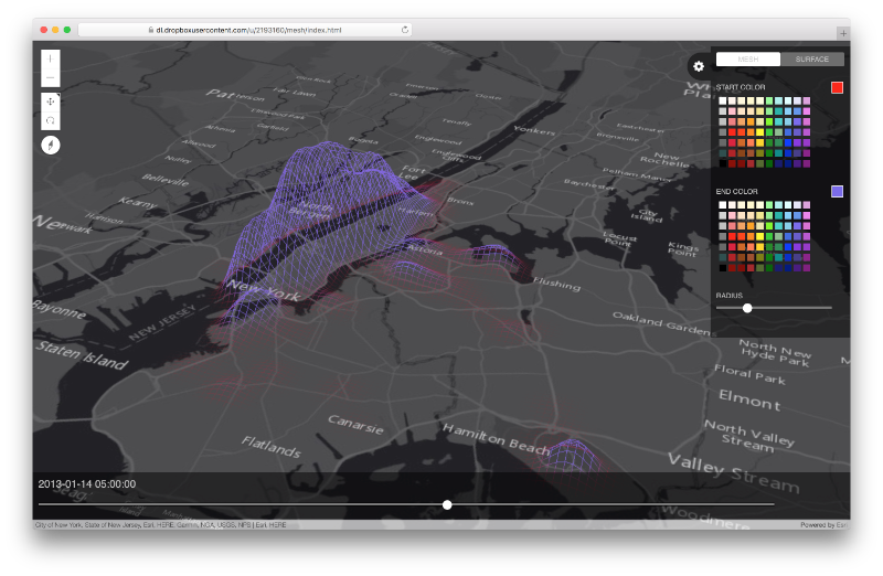
Start by viewing this application.
Make sure to tilt the map by holding down the right mouse button and sliding the mouse up. Then, slide the bottom slider back and forth to see the data "ripple" through time. This is displaying the density of 1 million NYC taxi pickups aggregated over 30 minute intervals. This application is based on the new 4.2 ArcGIS API for JavaScript and specifically on the externalRenderers capabilities, where a JS application can delegate the rendering to custom WebGL code.
This project is divided into 2 sub-projects:
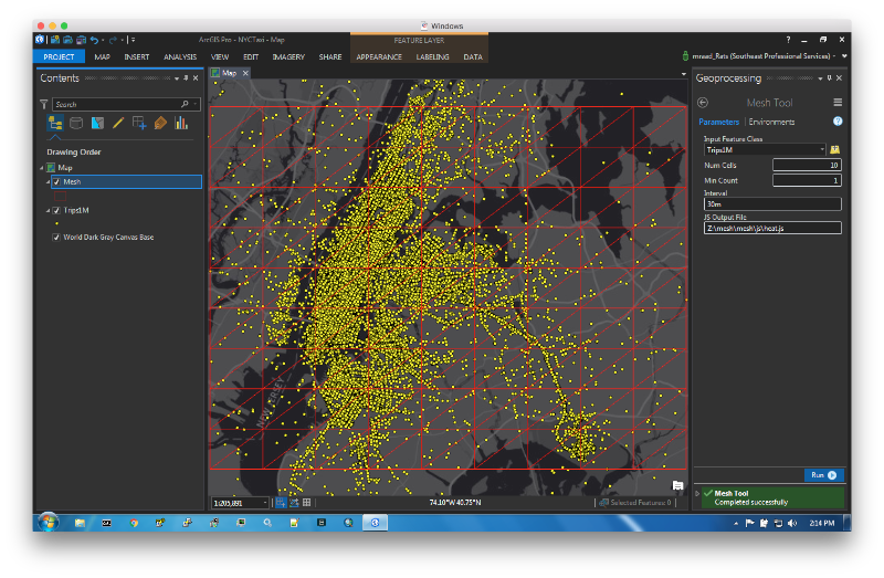
- An ArcPy based Pro toolbox to aggregate and prepare the data.
- A JavaScript application to view the prepared data.
Make sure to pip install sortedcontainers.
This tool bins over space and time the input point features to produce on the local file system a "space-time-cube" in the form of a DOJO AMD Module. The following is a very simplistic output, but demonstrates the module content.
define({
    "mesh": {
        "ymax": 40.86254766648426,
        "xmin": -74.0984483274695,
        "ymin": 40.632320706393344,
        "cols": 2,
        "rows": 2,
        "vertices": [-74.0984483274695, 40.86254766648426, 100, -73.69913039514432, 40.86254766648426, 100, -74.0984483274695, 40.632320706393344, 100, -73.69913039514432, 40.632320706393344, 100],
        "xmax": -73.69913039514432,
        "indices": [1, 0, 2, 2, 3, 1],
        "length": 4
    },
    "data": {
        "min": 980557.0,
        "stddev": 0.0,
        "max": 980557.0,
        "mean": 980557.0,
        "data": [{"datetime": "2012-12-21 00:00:00", "points": [{"w": 0.2, "r": 1, "p": 980557, "c": 0}]}]
    }
});
The mesh property has the world extent (xmin,ymin,xmax,ymax) of the mesh based on the map current extent, and defines the vertices of the nodes forming the mesh as a sequence of triples (lon,lat,elevation). WebGL renders the mesh as a sequence of triangles using the WebGLRenderingContext.drawElements() where the mode is set to gl.TRIANGLES. The drawElements uses the indicies and the "converted" (more on this later) vertices to draw efficiently and quickly the triangles.
The data property defines the space-time-cube. During the module preparation, the input features are binned by space using their geometry into rows and column tuples and by time using their temporal attribute into interval buckets. In addition, the mean and stddev of the bin counts are calculate using an online variance. The values min and max values are derived using mean ± stddev and used to weight the bin count (p) and produce a weight w ∈ [0,1] in the subsequently defined points elements.
The data sub-property is an array of objects sorted by datetime interval buckets and contain a points sub-property. The latter is an array of objects with population bin count values (p) for a mesh row (r) and column (c) vertex.
So for each time interval bucket, the mesh vertices are "elevated" and color coded in proportion to their w point value.
The Interval parameter in the tool accepts a string in the form of a number followed by either a s (seconds), m (minutes), d (days), w (weeks). So a string value of 30s means an interval of 30 seconds, and a string value of 2d means an interval of 2 days.
This tool depends on SortedContainers, so make sure to use Add Packages to add the library to your Pro Python environment.
The generated space-time cube JavaScript code is loaded at startup time into the application as an AMD module and is rendered using the 4.2 ArcGIS API for JavaScript with the experimental externalRenderers which enables the application to invoke WebGL shaders. The shaders are compiled and initialized in the setup function of an externalRenderer instance and continuously invoked in the render function.
The following is a snippet in the render function:
var camera = context.camera;
gl.uniformMatrix4fv(this.pMatrixUniform, false, camera.projectionMatrix);
gl.uniformMatrix4fv(this.vMatrixUniform, false, camera.viewMatrix);

externalRenderers.toRenderCoordinates(
    this.view,
    this.vertices,
    0,
    SpatialReference.WGS84,
    this.arrPosition,
    0,
    appMesh.length);
Note how we are taking advantage to the camera projection matrix and view matrix properties to populate the vertex shader uPMatrix and uVMatrix uniforms used in the gl_Position calculation. In addition, and this is SOOOO USEFUL, note the usage of the toRenderCoordinates(...) function that converts the mesh vertices world coordinates to WebGL coordinates based on the camera position.
The application enables the user to drag back and forth a slider where the slider position is an index into the space-time cube data.data array, where all the points associated with that "datetime" will be mapped to the mesh vertices and elevated.
The vertex elevation is proportional to the w value of a point. In addition, all the neighboring vertices are also elevated, but in proportion to a kernel distance function providing a smooth elevated surface.
To view the application, place the mesh folder in your web server or you can start a simple web server in the mesh folder:
python -m SimpleHTTPServer 8000
Open a browser (preferably Chrome) and navigate to http://localhost:8000/index.html
Note that the kernel elevation is occurring in the kernel.ts code writen in TypeScript. I have to confess that is a bit selfish on my part for "mixing" languages, as JavaScript is not my favorite language, and I long for the days when I used to write statically typed AS3 code. Typescript is pretty cool, has great community support and we at Esri have made significant investments in supporting it. Check out this github repo to setup your development environment.
In addition, it is HIGHLY recommended to use an IDE like IntelliJ or WebStorm with TypeScript support If you need to modify the js/kernel.ts file.
- https://www.khronos.org/files/webgl/webgl-reference-card-1_0.pdf
- https://webglfundamentals.org/webgl/lessons/webgl-fundamentals.html
- Initialize the project using
npm init - Install TS typings using
npm install --save @types/arcgis-js-api


