Planet Coverage Finder helps find complete coverages of a user's area using PlanetScope scenes.
You can install the package and its dependencies using pip:
$ pip install .
This will install the command-line executable pcf. Because Planet Coverage Finder uses version 1.5 of the Planet Python client, it is recommended that authentication be done by setting the PL_API_KEY environment variable with your API key.
The tool will take an input area (or areas) plus time range and attempt to find a single day in which PlanetScope imagery covers the area completely.
$ pcf map.geojson 2022-01-01 2022-02-28
1: checking 2022-02-28 for coverage
1: checking 2022-02-27 for coverage
2: checking 2022-02-28 for coverage
1: SUCCESS (date: 2022-02-27 scenes: 1)
2: SUCCESS (date: 2022-02-28 scenes: 3)
The output shows that there were two features in the input file map.geojson and that the tool was able to find a complete coverage for the first feature on 2022-02-27 and a coverage for the second feature on 2022-02-28.
If the features in map.geojson have an attribute that can use used to better identify them, then it can be specified with the --attribute parameter:
$ pcf map.geojson 2022-01-01 2022-02-28 --attribute name
Munich: checking 2022-02-28 for coverage
Munich: checking 2022-02-27 for coverage
Berlin: checking 2022-02-28 for coverage
Munich: SUCCESS (date: 2022-02-27 scenes: 1)
Berlin: SUCCESS (date: 2022-02-28 scenes: 3)
To see detailed information on which scenes and their exact areas were used to create this coverage, the following parameters can be used:
  -o, --output TEXT               Name to use for all output files.
  -u, --geojson-unusable          Save a GeoJSON with the AOIs for which there were not any usable results.
  -Q, --qgis                      QGIS project file for results.
  -x, --xyz                       Create an XYZ tile service URL.
  -w, --wmts                      Create a WMTS tile service URL.
If -o is provided, all output files will use this prefix; if it isn't provided, the output filenames will be based on the input file.
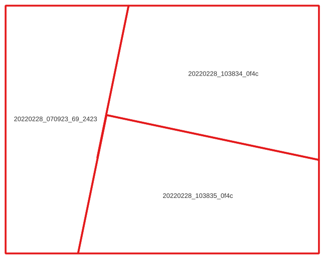
The output GeoJSON file for successful searches will show the required scenes and the exact part of each scene to provide the 100% coverage:
The default search assumes that the user needs 100% coverage on a single day and doesn't care about clouds. Planet Coverage Finder can help restrict the resutls to match specific requirements:
  -c, --max-clouds INTEGER RANGE  Maximum cloud cover percentage.  [0<=x<=100]
  -C, --confidence INTEGER RANGE  Required confidence when using UDM-based cloudiness checks.  [0<=x<=100]
  -m, --mask-types [cloud|shadow|haze|snow]
  				  UDM2 types to consider when evaluating cloudiness of images.
  -f, --frame INTEGER RANGE       Time frame in days to search for acceptable data (all images will be captured within this many days of one another).  [x>=1]
  -q, --image-quality [all|standard|preferential]
                                  How to handle images of different quality.
  -s, --satellite TEXT            Satellite generation: PS0, PS1, PS2, PS2.SD, PSB.SD.
  -t, --min-cover INTEGER RANGE   Required coverage percentage.  [1<=x<=100]
If one or more -m parameters are used, then pcf will use the Usable Data Mask (UDM) file to calcualte the exact cloudiness and confidence score; if no -m parameters are provided, it will estimate cloudiness based on the scene-level metadata, with a confidence of at least 0. pcf uses UDM version 2.1, and therefore does not accept lighthaze or heavyhaze as parameters.
By default, images of all qualities will be considered, but images that were automatically assessed to be test quality will only be added to the coverage if there are no images of standard quality available. By setting --image-quality to standard, test images will be excluded, and by using all, the tool will not distinguish between different image qualities.
Using the --frame parameter will perform a search over a rolling window of multiple days instead of requiring data to be from a single day only.
Planet Coverage Finder can also create an order for each feature.
  --order / --no-order            Submit an order for scenes.
  -b, --bundle TEXT               Bundles to order.
  -e, --email                     Send email for each order.
  -r, --reproject INTEGER         Reproject to a specific SRS (or no reprojection if set to 0).
WARNING: The tool will only clip the images to the original search area. In the example image above, three images would be ordered, each clipped to the same large rectangle. This could lead to unexpected quota charges.
The following command, will find imagery for each feature in aoi.geojson in September 2019. The features must be at least 90% covered by imagery and the imagery must be at most 10% cloudy (defined as haze or clouds). A GeoJSON file will contain the geometries of PlanetScope imagery used to successfully provide a coverage over each feature, and a QGIS project will be created to view the results.
pcf aoi.geojson 2019-09-01 2019-09-30 -c 10 -t 90 -m haze -m cloud --qgis
