In this project, I devised and implemented an algorithm to model a drone's flight path, making deliveries from synthetic test data to check if a drone delivery system would be feasible and if the drone could complete all orders for the day before running out of battery. To do this, I optimised the greedy heuristic, Dijkstra's algorithm and christofides algorithm to get the best flight path that completed the delivery for 99% of the test data.
- Java
- Apache Database
- GeoJSON
Devise and implement an algorithm to model a drone's flight path, making deliveries from synthetic test data to check if a drone delivery system would be feasible and if the drone could complete all orders for the day before running out of battery.
The algorithm works such that the route is calculated and its movements are returned. The algorithm that calculates the shortest path is simple but the graph that allows this algorithm to work is what can be confusing
I had initially wanted to use the Christofides algorithm as a TSP algorithm to solve the problem of which order to complete first. For that algorithm to work, I would need to create a graph of equilateral triangles made up of nodes and edges whereby for each node, it would have at least 2 neighbouring node which will form an equilateral triangle. I then added all of the nodes and edges to a graph. I then checked if each node and edge on the graph was valid. A node or edge is valid if it is in the confinement area,not in the no fly zone and does not cross the no fly zone. If a node or edge is invalid, then I would remove the node or edge entirely. Since there are no nodes or edges in the no fly zone or outside the confinement area, the drone cannot traverse there,hence it is impossible to be in an invalid location.
To traverse the graph the drone first had to find the nodes close to the locations it wants to go to.Once the nodes are found, the drone can find the shortest path. It uses one of the TSP algorithms to find the most optimum order of the orders to complete. The drone uses Dijkstra shortest path algorithm from jgrapht to find the shortest path on the graph I had previously between 2 points. I had tried using Astar shortest path algorithm with the eucleadian distance as the admissible heuristic but it did not work any much better than Dijkstra so I stuck with Dijkstra (you can use the A* algorithm by uncommenting it in the code and commenting the Dijkstra line)While the drone is moving between orders, the index of the nodes in the list of nodes when the drone hovers and moves on to the next order is recorded. This will be used later when writing the data to the database The algorithm is simple as for each order I just need to find the path with the shortest distance between the pick up and delivery locations and add it to the list of movement. I do not need to worry about the drone moving into the no-fly zone or out of the confinement area as I know that would never happen since I have already removed those nodes and edges.
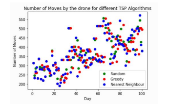
To maximise the amount of money earned per day I would need to use an algorithm that would prioritise certain orders over the other. I had initially wanted to use Christofides algorithm as it seemed to have the best results. However, due to a lack of time I was unable to implement it. Instead I implemented 3 others which are the greedy approach,nearest neighbour approach and lastly the random approach. The greedy approach seemed to be the best among the three as it prioritised the money earned which is the main objective of the system. Even on the day with the greatest number of orders which is 27/12/2023 the percentage of monetary value is 84% which is higher than the other algorithms. Hence, the greedy approach gave the most optimal order or orders that the drone should complete. I also tested each approach on 100 different days and plotted a scatter diagram to convey my results. From the diagram it is obvious that the greedy approach and nearest neighbour approach have similar results.
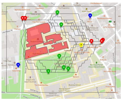
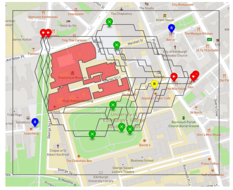
Drone path on 11/11/2022 Drone path on 12/12 /2022

