This is a collection of .poly files for cities, with the definition of 'city' being the area one level under the region/state level. There isn't a whole lot of concern here for discrepancies between cities, towns, villages, etc.
These .poly files are used to then extract just the city's OSM file from a greater region's OSM file. For example, creating an exact OSM file for Boston from the North America OSM file. More information on actually using the .poly files is provided at the bottom of this document.
The ultimate goal is to have them all, but it's a rough process right now. The process explained below shows how to retrieve the .poly file for a specific city, but the process I've gone through to gather most of the files in this repository is much more automated and uses Overpass Turbo.
I have the OSM file for each of the cities in this repository. If you would like access to those files, contact me.
Sometimes a city won't have a Relation ID, or the Relation that exists will be broken. For those instances, the final OSM file can be created manually by tracing the city at http://extract.bbbike.org/. Just make sure to select one of the 'OSM XML' formats in the top pulldown menu there.
-
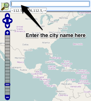
Go to http://nominatim.openstreetmap.org/ and search for the city you'd like added
-
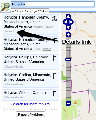
Click the 'details' link for that city in the left column
-
Make sure that the map on the right displays the full city border
-
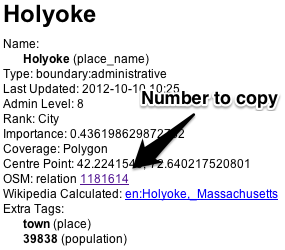
Copy the number for 'OSM: relation'
-
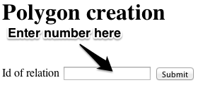
Go to http://polygons.openstreetmap.fr/, paste the number into the form, and click the Submit button
-
Click the 'poly' link to open the file in the browser, then use
File -> Save Asto save the file -
The naming convention I've been using is
city-name_state-abbreviation.poly. For example,holyoke_ma.poly
You can use the .poly file to extract that region from a greater region's OSM file.
- Install Osmosis
- If you're on a Mac, I suggest you use Homebrew to install it with
brew intsall osmosis
- If you're on a Mac, I suggest you use Homebrew to install it with
- Download the
.osm.pbffile for the region that the city is in from http://download.geofabrik.de/ - Run this to extract the city's OSM file out of the greater region's OSM file:
osmosis --read-pbf-fast file="YOUR-REGION-latest.osm.pbf" --bounding-polygon file="CITY-NAME_STATE.poly" --write-xml file="CITY-NAME_STATE.osm"For example:osmosis --read-pbf-fast file="north-america-latest.osm.pbf" --bounding-polygon file="holyoke_ma.poly" --write-xml file="holyoke_ma.osm"
I have the OSM file for each of the cities in this repository. If you would like access to those files, contact me.


