This is the home of the NISMOD v2 Transport Model.
NISMOD v2 Transport Model is a national-scale (Great Britain) transport model developed to support policy making regarding the future infrastructure. It forecasts the impact of various endogenous and exogenous factors on transport demand and capacity utilisation, following an elasticity-based simulation methodology. The model consists of three submodels covering the following modes of transport: road (passenger and freight vehicle flows), rail (total station usage), and air (domestic and international passenger movements).
- Install Java Development Kit version 8 from: http://www.oracle.com.
- Install Eclipse IDE for Java Developers: https://eclipse.org/downloads/.
- Run Eclipse and choose the workspace folder.
- Import the existing Maven project from the local git folder where the code has been cloned. In Eclipse: File -> Import -> Maven -> Existing Maven Projects. Wait until all Maven dependencies (specified in the pom.xml file) are downloaded. If the pom.xml file has been changed, the Maven project should be first updated (Alt+F5).
- The classes containing the main method can be run as a Java application. The classes containing the methods annotated with @Test can be run as JUnit tests.
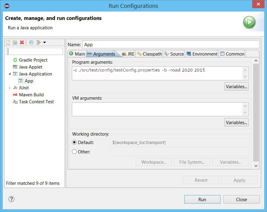
- To run the main model in Eclipse, open the Run Configuration for nismod.transport.App.java and pass the path to the config file as an argument:
- Alternatively, to build the project and run the main model in the command prompt:
-
Make sure the Java home environment variable is set for the operating system and pointing to the directory where Java Development Kit has been installed.
-
Download maven, install it and set the environment variables: http://maven.apache.org/. Then type:
mvn clean install -
To run the base-year road model (2015) type:
java -cp target/transport-0.0.1-SNAPSHOT.jar nismod.transport.App -c ./path/to/config.properties -b -
To predict and run a future year (e.g. 2020) using the results of a previously run year (e.g. 2015), for road model type:
java -cp target/transport-0.0.1-SNAPSHOT.jar nismod.transport.App -c ./path/to/config.properties -road 2020 2015 -
To predict and run a future year (e.g. 2020) using the results of a previously run year (e.g. 2015), for rail model type:
java -cp target/transport-0.0.1-SNAPSHOT.jar nismod.transport.App -c ./path/to/config.properties -rail 2020 2015 -
To predict and run a future year (e.g. 2020) using the results of a previously run year (e.g. 2015), for air model type:
java -cp target/transport-0.0.1-SNAPSHOT.jar nismod.transport.App -c ./path/to/config.properties -air 2020 2015 -
To run the interactive showcase demo (1920 x 1080 resolution required) type:
java -cp target/transport-0.0.1-SNAPSHOT.jar nismod.transport.App -c ./path/to/config.properties -d -
Options:
- To increase the max heap size, run with
java -XX:MaxHeapSize=120g ... - To enable debug messages, run with
java -Dlog4j2.debug ...
- To increase the max heap size, run with
-
- Update the model version in
transport/pom.xml - Run
maketo build model jar and testdata zip - Tag the latest commit (using
git tag -aandgit push --tags) - Make a GitHub release, with notes on fixes and new features
- Milan Lovric lovric.milan@gmail.com / M.Lovric@soton.ac.uk (Modelling and development)
- Simon Blainey S.P.Blainey@soton.ac.uk (MISTRAL Co-Lead)
- John Preston J.M.Preston@soton.ac.uk (MISTRAL Co-Lead)
- Manuel Buitrago mbm1d15@soton.ac.uk (Seaports and freight)
This work has been undertaken at the University of Southampton, as part of the ITRC consortium, under grant EP/N017064/1 (MISTRAL: Multi-scale InfraSTRucture systems AnaLytics) of the UK Engineering and Physical Science Research Council (EPSRC). https://www.itrc.org.uk/
The test resources contain a sample of data and shapefiles that come with the following licencing and copyright statemens:
- Open Government Licence: http://www.nationalarchives.gov.uk/doc/open-government-licence/version/3/
- Contains National Statistics data © Crown copyright and database right 2012.
- Contains Ordnance Survey data © Crown copyright and database right 2012.
The authors acknowledge the use of the IRIDIS High Performance Computing Facility, and associated support services at the University of Southampton, in the completion of this work.
The implementation uses an open source library GeoTools for geospatial processing. http://www.geotools.org/about.html


