

![]()
![]()
mregions2 allows to access the Marine Regions Gazetteer and the Marine Regions Data Products in R.
You can find detailed information in the articles online:

(Source: https://www.vliz.be/en/news?p=show&id=8160)
You can install the development version of mregions2 from GitHub with:
# install.packages("devtools")
devtools::install_github("lifewatch/mregions2")
Load the library with
library(mregions2)The Marine Regions Gazetteer is a standard list of marine georeferenced place names.
Gazetteer: a dictionary of geographical names.
https://www.thefreedictionary.com/gazetteer
You can search the Gazetteer in many ways:
Search by free text:
gaz_search("Belgian")
#> # A tibble: 9 × 14
#>   MRGID gazetteerSource       placeType preferredGazett… preferredGazett… status
#>   <int> <chr>                 <chr>     <chr>            <chr>            <chr>
#> 1    14 "(2001). The Times c… Nation    Belgien          German           stand…
#> 2  2550 "ASFA thesaurus"      Coast     Belgian Coast    English          stand…
#> 3  2554 "ASFA thesaurus"      Coast     Belgian West Co… English          stand…
#> 4  3293 "Flanders Marine Ins… EEZ       Belgian Contine… English          stand…
#> 5  3293 "Flanders Marine Ins… EEZ       Belgian Exclusi… English          stand…
#> 6 24493 "Belgian Sea Fisheri… Historic… (Historical) fi… English          stand…
#> 7 26567 "VLIZ (2020). Inters… Marine R… Belgian part of… English          synon…
#> 8 49010 "Flanders Marine Ins… Territor… Belgian 12 NM    English          stand…
#> 9 49243 "Flanders Marine Ins… Contiguo… Belgian 24 NM    English          stand…
#> # … with 8 more variables: accepted <int>, latitude <dbl>, longitude <dbl>,
#> #   minLatitude <dbl>, minLongitude <dbl>, maxLatitude <dbl>,
#> #   maxLongitude <dbl>, precision <dbl>
Search by unique identifier. See ?MRGID:
gaz_search(3293)
#> # A tibble: 1 × 14
#>   MRGID gazetteerSource    placeType latitude longitude minLatitude minLongitude
#>   <int> <chr>              <chr>        <dbl>     <dbl>       <dbl>        <dbl>
#> 1  3293 Flanders Marine I… EEZ           51.5      2.71        51.1         2.24
#> # … with 7 more variables: maxLatitude <dbl>, maxLongitude <dbl>,
#> #   precision <dbl>, preferredGazetteerName <chr>,
#> #   preferredGazetteerNameLang <chr>, status <chr>, accepted <int>
Search by location:
gaz_search(x = 2.927, y = 51.21551)
#> # A tibble: 50 × 14
#>    MRGID gazetteerSource          placeType minLatitude minLongitude maxLatitude
#>    <int> <chr>                    <chr>           <dbl>        <dbl>       <dbl>
#>  1    14 (2001). The Times compr… Nation           49.5         2.55        51.5
#>  2    14 (2001). The Times compr… Nation           49.5         2.55        51.5
#>  3    14 (2001). The Times compr… Nation           49.5         2.55        51.5
#>  4    14 (2001). The Times compr… Nation           49.5         2.55        51.5
#>  5    14 (2001). The Times compr… Nation           49.5         2.55        51.5
#>  6    14 (2001). The Times compr… Nation           49.5         2.55        51.5
#>  7    20 SAIL                     Province…        50.7         2.55        51.4
#>  8    20 SAIL                     Province…        50.7         2.55        51.4
#>  9    20 SAIL                     Province…        50.7         2.55        51.4
#> 10    20 SAIL                     Province…        50.7         2.55        51.4
#> # … with 40 more rows, and 8 more variables: maxLongitude <dbl>,
#> #   preferredGazetteerName <chr>, preferredGazetteerNameLang <chr>,
#> #   status <chr>, accepted <int>, latitude <dbl>, longitude <dbl>,
#> #   precision <dbl>
Search by place type:
gaz_search_by_type("EEZ")
#> # A tibble: 254 × 14
#>    MRGID gazetteerSource   placeType latitude longitude minLatitude minLongitude
#>    <int> <chr>             <chr>        <dbl>     <dbl>       <dbl>        <dbl>
#>  1  3293 Flanders Marine … EEZ           51.5      2.71        51.1         2.24
#>  2  5668 Flanders Marine … EEZ           53.6      4.19        51.0         2.54
#>  3  5669 Flanders Marine … EEZ           54.6      8.39        52.9         3.35
#>  4  5670 Flanders Marine … EEZ           40.9     19.1         39.6        18.3
#>  5  5672 Flanders Marine … EEZ           42.9     29.2         42.0        27.4
#>  6  5673 Flanders Marine … EEZ           43.4     15.7         41.6        13.0
#>  7  5674 Flanders Marine … EEZ           56.1      9.25        54.4         3.25
#>  8  5675 Flanders Marine … EEZ           58.8     23.0         57.6        20.4
#>  9  5676 Flanders Marine … EEZ           61.8     21.9         58.8        19.1
#> 10  5677 Flanders Marine … EEZ           46.0     -1.97        41.2        -9.88
#> # … with 244 more rows, and 7 more variables: maxLatitude <dbl>,
#> #   maxLongitude <dbl>, precision <dbl>, preferredGazetteerName <chr>,
#> #   preferredGazetteerNameLang <chr>, status <chr>, accepted <int>
Search by authortative source:
gaz_search_by_source("Flanders Marine Institute (VLIZ)")
#> # A tibble: 23 × 13
#>    MRGID gazetteerSource           placeType latitude longitude preferredGazett…
#>    <int> <chr>                     <chr>        <dbl>     <dbl> <chr>
#>  1 62642 Seys, J.; Pint, S.; Verv… Sampling…     51.3      3.16 SW-Blankenberge…
#>  2 62643 Seys, J.; Pint, S.; Verv… Sampling…     51.2      2.96 SW-Bredene-01
#>  3 62644 Seys, J.; Pint, S.; Verv… Sampling…     51.3      3.26 SW-Duinbergen-01
#>  4 62645 Seys, J.; Pint, S.; Verv… Sampling…     51.3      3.00 SW-De Haan-Voss…
#>  5 62646 Seys, J.; Pint, S.; Verv… Sampling…     51.3      3.24 SW-Heist-01
#>  6 62647 Seys, J.; Pint, S.; Verv… Sampling…     51.1      2.62 SW-Koksijde-01
#>  7 62648 Seys, J.; Pint, S.; Verv… Sampling…     51.2      2.81 SW-Middelkerke-…
#>  8 62649 Seys, J.; Pint, S.; Verv… Sampling…     51.2      2.71 SW-Nieuwpoort-01
#>  9 62650 Seys, J.; Pint, S.; Verv… Sampling…     51.1      2.69 SW-Oostduinkerk…
#> 10 62651 Seys, J.; Pint, S.; Verv… Sampling…     51.2      2.94 SW-Oostende_Oos…
#> # … with 13 more rows, and 7 more variables: preferredGazetteerNameLang <chr>,
#> #   status <chr>, accepted <int>, minLatitude <dbl>, minLongitude <dbl>,
#> #   maxLatitude <dbl>, maxLongitude <dbl>
The list of place types and sources are available with gaz_types() and
gaz_sources() respectively.
You can add the geometry of the Gazetteer entries with gaz_geometry():
# Get a record and turn into a sf object with geometry
gaz_search(3293) %>% gaz_geometry()
#> Simple feature collection with 1 feature and 14 fields
#> Geometry type: MULTIPOLYGON
#> Dimension:     XY
#> Bounding box:  xmin: 2.238333 ymin: 51.08931 xmax: 3.370403 ymax: 51.87611
#> Geodetic CRS:  WGS 84
#> # A tibble: 1 × 15
#>   MRGID gazetteerSource    placeType latitude longitude minLatitude minLongitude
#>   <int> <chr>              <chr>        <dbl>     <dbl>       <dbl>        <dbl>
#> 1  3293 Flanders Marine I… EEZ           51.5      2.71        51.1         2.24
#> # … with 8 more variables: maxLatitude <dbl>, maxLongitude <dbl>,
#> #   precision <dbl>, preferredGazetteerName <chr>,
#> #   preferredGazetteerNameLang <chr>, status <chr>, accepted <int>,
#> #   the_geom <MULTIPOLYGON [°]>

# Or get only the geometry
gaz_geometry(3293, format = "sfc")
#> Geometry set for 1 feature
#> Geometry type: MULTIPOLYGON
#> Dimension:     XY
#> Bounding box:  xmin: 2.238333 ymin: 51.08931 xmax: 3.370403 ymax: 51.87611
#> Geodetic CRS:  WGS 84
#> MULTIPOLYGON (((3.370403 51.36696, 3.369459 51....
The entries of the Marine Regions Gazetteer are organized
hierarchically. You can browse this hierarchy up and down with
gaz_relations()
# Get all relations
gaz_search(3293) %>% gaz_relations()
#> # A tibble: 31 × 14
#>    MRGID gazetteerSource   placeType latitude longitude minLatitude minLongitude
#>    <int> <chr>             <chr>        <dbl>     <dbl>       <dbl>        <dbl>
#>  1  3293 Flanders Marine … EEZ           51.5      2.71        51.1         2.24
#>  2  2419 ASFA thesaurus    Sandbank…     51.5      2.58        NA          NA
#>  3  2420 ASFA thesaurus    Sandbank…     51.5      2.88        NA          NA
#>  4  2421 ASFA thesaurus    Sandbank…     51.3      2.64        NA          NA
#>  5    14 (2001). The Time… Nation        50.5      4.48        49.5         2.55
#>  6  2350 (1953). Limits o… IHO Sea …     56.4      2.74        51.0        -4.45
#>  7  4675 <NA>              Sandbank…     NA       NA           NA          NA
#>  8  2550 ASFA thesaurus    Coast         51.2      2.91        51.1         2.54
#>  9 17401 Aphia             Wreck         51.4      2.32        NA          NA
#> 10 17409 Aphia             Wreck         51.1      2.33        NA          NA
#> # … with 21 more rows, and 7 more variables: maxLatitude <dbl>,
#> #   maxLongitude <dbl>, precision <dbl>, preferredGazetteerName <chr>,
#> #   preferredGazetteerNameLang <chr>, status <chr>, accepted <int>

# Or get the relations directly
gaz_relations(3293)
#> # A tibble: 31 × 14
#>    MRGID gazetteerSource   placeType latitude longitude minLatitude minLongitude
#>    <int> <chr>             <chr>        <dbl>     <dbl>       <dbl>        <dbl>
#>  1  3293 Flanders Marine … EEZ           51.5      2.71        51.1         2.24
#>  2  2419 ASFA thesaurus    Sandbank…     51.5      2.58        NA          NA
#>  3  2420 ASFA thesaurus    Sandbank…     51.5      2.88        NA          NA
#>  4  2421 ASFA thesaurus    Sandbank…     51.3      2.64        NA          NA
#>  5    14 (2001). The Time… Nation        50.5      4.48        49.5         2.55
#>  6  2350 (1953). Limits o… IHO Sea …     56.4      2.74        51.0        -4.45
#>  7  4675 <NA>              Sandbank…     NA       NA           NA          NA
#>  8  2550 ASFA thesaurus    Coast         51.2      2.91        51.1         2.54
#>  9 17401 Aphia             Wreck         51.4      2.32        NA          NA
#> 10 17409 Aphia             Wreck         51.1      2.33        NA          NA
#> # … with 21 more rows, and 7 more variables: maxLatitude <dbl>,
#> #   maxLongitude <dbl>, precision <dbl>, preferredGazetteerName <chr>,
#> # preferredGazetteerNameLang <chr>, status <chr>, accepted <int>In addition to the Marine Regions Gazetteer, the Marine Regions Team creates and hosts geographical Data Products, being the most popular one the Marine Regions Maritime Boundaries.
An overview of all available products can be consulted with mrp_list
mrp_list
#> # A tibble: 21 × 8
#>    title                   namespace layer license citation doi   imis  abstract
#>    <chr>                   <chr>     <chr> <chr>   <chr>    <chr> <chr> <chr>
#>  1 Exclusive Economic Zon… MarineRe… eez   Creati… "Flande… http… http… "Versio…
#>  2 Maritime Boundaries (v… MarineRe… eez_… Creati… "Flande… http… http… "Versio…
#>  3 Territorial Seas (12 N… MarineRe… eez_… Creati… "Flande… http… http… "Versio…
#>  4 Contiguous Zones (24 N… MarineRe… eez_… Creati… "Flande… http… http… "Versio…
#>  5 Internal Waters (v3, w… MarineRe… eez_… Creati… "Flande… http… http… "Versio…
#>  6 Archipelagic Waters (v… MarineRe… eez_… Creati… "Flande… http… http… "Versio…
#>  7 High Seas (v1, world, … MarineRe… high… Creati… "Flande… http… http… "High S…
#>  8 Extended Continental S… MarineRe… ecs   Creati… "Flande… http… http… "This d…
#>  9 Extended Continental S… MarineRe… ecs_… Creati… "Flande… http… http… "This d…
#> 10 IHO Sea Areas (v3)      MarineRe… iho   Creati… "Flande… http… http… "World …
#> # … with 11 more rows
You can visualize the Marine Regions Data Products with mrp_view(). It
opens an interactive leaflet::leaflet viewer.
mrp_view("eez")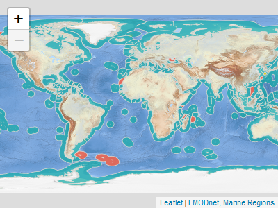
Or you can download and read the data products into R with mrp_get()
mrp_get("eez")You can specify the download path in the path argument:
mrp_get("eez", path = "path/to/data")Get to know more in the Get Started vignette.
citation("mregions2")
#> To cite package 'mregions2' in publications use:
#>
#>   Fernandez-Bejarano S, Pohl L (2023). _mregions2: Access Data from
#>   Marineregions.org: The Marine Regions Gazetteer and the Marine
#>   Regions Data Products_. <https://github.com/lifewatch/mregions2>.
#>
#> A BibTeX entry for LaTeX users is
#>
#>   @Manual{,
#>     title = {{mregions2}: Access Data from Marineregions.org: The Marine Regions Gazetteer and the Marine Regions Data Products},
#>     author = {Salvador Fernandez-Bejarano and Lotte Pohl},
#>     year = {2023},
#>     url = {https://github.com/lifewatch/mregions2},
#> }MIT. See LICENSE.md
Please note that the mregions2 project is released with a Contributor Code of Conduct. By contributing to this project, you agree to abide by its terms.