JasperReports is the world's most popular open source reporting engine. It is able to use data coming from any kind of data source and produce pixel-perfect documents that can be viewed, printed or exported in a variety of document formats including HTML, PDF, Excel, OpenOffice and Word. Report templates can be created with the iReport Designer on the desktop.
This extension allows to embedding maps served with the standardized Web Map Service (WMS) protocol.
The extension requires Jasperreports/iReport version 5.0.x. The extension consists of 2 artifacts:
- A iReport Designer Plugin that adds the WMS Map report element to the iReport component palette as well as editing WMS properties
- A JasperReports extension that provides rendering capabilities for WMS map report elements
The extension supports all JasperReports output formats (HTML, PDF, etc.).
Download com-sourcepole-ireport-wms-*.nbm from https://github.com/sourcepole/jasperreports-wms-component/releases
In iReport Designer:
- choose 'Tools' -> 'Plugins' from the menu
- to uninstall a previous version of the plugin:
- select tab 'Installed'
- select the Entry in the list
- click 'Uninstall' (requires restart of iReport)
- to install a new version of the plugin:
- select tab 'Downloaded'
- click 'Add Plugins...'
- choose the plugin package (
com-sourcepole-ireport-wms-*.nbm) from the file system - click 'Install'
- in the dialog that appears, click 'next'
- check 'Accept License' and click 'install'
- a warning appears that the plugin is not signed, click 'Continue'
- if the plugin could be installed, click 'Finish'
- in the plugin dialog, click 'close'
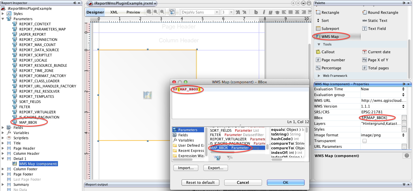
If the iReport plugin has been installed properly in iReport Designer, an additional component WMS Map should be available in the components Palette. Simply drag-and-drop the palette element to add new WMS map elements. If the element is selected, the Properties Inspector provides WMS specific input fields (Service URL, Bounding Box, etc.).
Like with any report element expressions may be used for some of the WMS map parameters:
- Bounding Box
- Layers
- Styles
- URL Parameters (extra parameters appended to the WMS request url)
To use a report parameter, e.g. for BBOX:
- Create a new report parameter, e.g. MAP_BBOX (default value expression
"634849.96085766,244281.95484911,635310.33560906,244655.89909163") - Reference this report parameter in the map element's bounding box property using the JasperReports expression syntax (
$P{MAP_BBOX})
Example:
- WMS URL:
http://wms.qgiscloud.com/olten/Solarkataster - WMS Version:
1.3 - SRS/CRS:
EPSG:21781 - Bbox:
$P{MAP_BBOX} - Layers:
Hintergrund,Kataster - Styles:
- Image format:
image/png - Transparent:
FALSE - URL Parameters:
"DPI=150"
When previewing the report in iReport, a prompt is shown to enter the MAP_BBOX parameter (unless the Use as a prompt option for the report parameter has been unchecked). Sample BBOX: 634849.96085766,244281.95484911,635310.33560906,244655.89909163
The example above generates the following WMS GetMap request:
Remarks:
- In WMS version 1.3 the parameter "SRS" has been renamed to "CRS".
- The DPI parameter is not standardized and vendor dependent. QGIS Server uses "DPI", UMN Mapserver "MAP_RESOLUTION" and GeoServer "FORMAT_OPTIONS=dpi:96"
Download jasperreports-wms-component-*.jar from https://github.com/sourcepole/jasperreports-wms-component/releases
Assuming a standard installation of JasperReports server on Apache Tomcat, just copy the extension JAR to the lib directory of the web application:
cp jasperreports-wms-component-*.jar $TOMCAT_HOME/webapps/jasperserver/WEB-INF/lib
Source code is available on https://github.com/sourcepole/jasperreports-wms-component.
Prerequisites to build the extension from source:
- JDK 6 or higher
- NetBeans Platform (to build the iReport Plugin) and iReport installation
- Apache Maven 3.0.x (http://maven.apache.org, to build the JasperReports extension)
To build the JasperReports extension:
- run
mvn clean installin the project directory - the extension artifact JAR file may be found in the
targetdirectory:jasperreports-wms-component-x.y.z.jar.
To build the iReport Plugin
- add iReport Platform to NetBeans (see: http://community.jaspersoft.com/wiki/introduction-custom-components-ireport-designer#Creation_of_the_plugin_in_NetBeans)
- open the iReport Plugin project (located in subdirectory
ireport-wms-plugin) in NetBeans - right-click the Project and select 'Properties'
- in 'Libraries', select the tab 'Wrapped Jars', and add the JasperReports extension JAR created before; click 'OK' to discard the properties dialog
- right-click the Project again and choose 'Create NBM'
- the plugin artifact
com-sourcepole-ireport-wms.nbmmay be found in thebuilddirectory
Copyright (c) 2013 Sourcepole AG
JasperReports/iReport WMS Component is free software: you can redistribute it and/or modify it under the terms of the GNU Lesser General Public License as published by the Free Software Foundation, either version 3 of the License, or (at your option) any later version.
JasperReports/iReport WMS Component is distributed in the hope that it will be useful, but WITHOUT ANY WARRANTY; without even the implied warranty of MERCHANTABILITY or FITNESS FOR A PARTICULAR PURPOSE. See the GNU Lesser General Public License for more details.
You should have received a copy of the GNU Lesser General Public License along with JasperReports/iReport WMS Component. If not, see <http://www.gnu.org/licenses/>.
