This is a brief introduction to searching and downloading imagery assets from NearSpace Labs. For more in-depth documentation go to NearSpace Labs nsl.stac repository
on Github.
The nsl.stac Python package lets you find aerial imagery by area of interest, data, and other attributes. It also downloads Near Space Labs Geotiffs and thumbnails. The client connects to Near Space Labs STAC service for imagery metadata queries and imagery server to retrieve imagery.
Request access to the NearSpace Labs API. You need these credentials to access services.
For this tutorial, install Anaconda which is a Python distribution that includes JupyterLabs. JupyterLabs provides a web-based interactive environment for data science and machine learning.
We will also use nsl.stac to connect to NearSpace Labs STAC server and retrieve imagery.
For each Python project, it's best practice to create a virtual environment that contains the packages required by the project. Anaconda includes a package manager called conda. Run the following to create a new virtual conda environment and activate it.
$ conda create --name venv python=3.8
$ conda activate venvWe need to add the JupyterLabs and numpy to our environment. Note that nsl.stac requires numpy 1.17.3 or greater and we will install it in the conda environment before installing nsl.stac.
$ conda install jupyter
$ conda install numpy=1.17.3
$ conda install matplotlib
$ conda install -c conda-forge rasterioThe conda package manager uses the Anaconda or CondaForge repositories. The nsl.stac package is not available in those repositories, but we can still use pip to install it from the PyPi repository.
$ pip install nsl.stacWe can start a Jupyter server with your NearSpace Labs credentials
$ NSL_ID="<my_id>" NSL_SECRET="my_secret" jupyter notebook
Open a new notebook.
Copy and paste the code example into the notebook to download and view a geotiff.
This example is modified from https://github.com/nearspacelabs/stac-client-python#first-code-example
Query and view image code
import tempfile, os
from IPython.display import Image, display
from datetime import date
import rasterio
from rasterio.plot import show
from nsl.stac import StacRequest, GeometryData, ProjectionData
from nsl.stac import enum, utils
from nsl.stac.client import NSLClient

# the client package stubs out a little bit of the gRPC connection code
# get a client interface to the gRPC channel. This client singleton is threadsafe
client = NSLClient()

# our area of interest will be the coordinates of the UT Stadium in Austin, Texas
# the order of coordinates here is longitude then latitude (x, y). The results of our query
# will be returned only if they intersect this point geometry we've defined (other geometry
# types besides points are supported)
# This string format, POINT(float, float) is the well-known-text geometry format:
# https://en.wikipedia.org/wiki/Well-known_text_representation_of_geometry
ut_stadium_wkt = "POINT(-97.7323317 30.2830764)"
# GeometryData is a protobuf container for GIS geometry information, the epsg in the spatial
# reference defines the WGS-84 ellipsoid (`epsg=4326`) spatial reference (the latitude longitude
# spatial reference most commonly used)
geometry_data = GeometryData(wkt=ut_stadium_wkt, proj=ProjectionData(epsg=4326))

# TimestampField is a query field that allows for making sql-like queries for information
# LTE is an enum that means less than or equal to the value in the query field
# Query data from August 25, 2019
time_filter = utils.pb_timestampfield(value=date(2019, 8, 25), rel_type=enum.FilterRelationship.LTE)

# the StacRequest is a protobuf message for making filter queries for data
# This search looks for any type of imagery hosted in the STAC service that intersects the austin
# capital area of interest and was observed on or before August 25, 2019
stac_request = StacRequest(datetime=time_filter, intersects=geometry_data)

# search_one method requests only one item be returned that meets the query filters in the StacRequest
# the item returned is a StacItem protobuf message. search_one, will only return the most recently
# observed results that matches the time filter and spatial filter
stac_item = client.search_one(stac_request)

# get the thumbnail asset from the assets map. The other option would be a Geotiff,
# with asset key 'GEOTIFF_RGB'
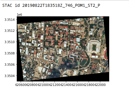
print("STAC id {}".format(stac_item.id))
asset = utils.get_asset(stac_item, asset_type=enum.AssetType.GEOTIFF)

# with save_dir as d:
d = os.getcwd()
filename = utils.download_asset(asset=asset, save_directory=d)
fp = filename
img = rasterio.open(fp)
show(img)
