Simple Google Maps address formatter and LatLng provider for Wagtail fields.
Check out Awesome Wagtail for more awesome packages and resources from the Wagtail community.
- Follow the instructions to get a key
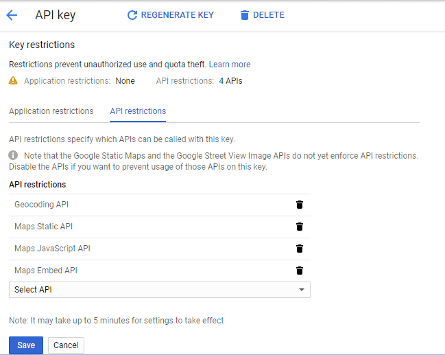
- Enable the following services under
API Restrictions:
-
Install with
pip install wagtailgmaps -
Add
wagtailgmapsto yoursettings.pyINSTALLED_APPSsection. -
Add some configuration in your
settings.pyfile:# Mandatory WAGTAIL_ADDRESS_MAP_CENTER = 'Wellington, New Zealand' # It must be a properly formatted address WAGTAIL_ADDRESS_MAP_KEY = 'xxx' # Optional WAGTAIL_ADDRESS_MAP_ZOOM = 8 # See https://developers.google.com/maps/documentation/javascript/tutorial#MapOptions for more information. WAGTAIL_ADDRESS_MAP_LANGUAGE = 'ru' # See https://developers.google.com/maps/faq#languagesupport for supported languages.
-
Use it:
# myapp/models.py
from django.db import models
from wagtail.wagtailcore.models import Page
from wagtailgmaps.edit_handlers import MapFieldPanel

class MapPage(Page):
    # Wagtailgmaps expects a `CharField` (or any other field that renders as a text input)
    formatted_address = models.CharField(max_length=255)
    latlng_address = models.CharField(max_length=255)

    # Use the `MapFieldPanel` just like you would use a `FieldPanel`
    content_panels = Page.content_panels + [
        MapFieldPanel('formatted_address'),
        MapFieldPanel('latlng_address', latlng=True),
    ]
# myapp/templates/myapp/map_page.html
<a href="http://maps.google.com/?q={{ self.formatted_address }}">Open map (Formatted Address)</a>
<a href="http://maps.google.com/?q={{ self.latlng_address }}">Open map (Lat/Long Address)</a>
heading- A custom heading in the admin, defaults to "Location"classname- Add extra css classes to the fieldlatlng- Field returns a LatLng instead of an addresscentre- A custom override for this fieldzoom- A custom override for this field
If using the address option, the field gets updated according to the Google Geocoding Service each time:
- The map marker gets dragged and dropped into a location (
dragendJS event). - Click happens somewhere in the map (
clickJS event). - Return key is pressed after editing the field (
enterKeyJS event for return key only).
When editing the model from the admin interface the affected field shows up with a map, like the screenshot above. If it doesn't, check your browser console to make sure that there is no error related to your API key.
- Make a new branch for the release of the new version.
- Update the CHANGELOG.
- Update the version number in
wagtailgmaps/__init__.py, following semver. - Make a PR and squash merge it.
- Back on master with the PR merged, use
make publish(confirm, and enter your password). - Finally, go to GitHub and create a release and a tag for the new version.
- Done!


