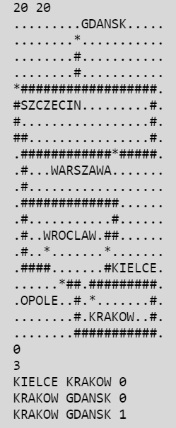
This project aims to provide a solution for finding the shortest travel time between cities on a rectangular map divided into squares. Each field on the map can either be empty (impassable), part of a road (passable in both directions), or a city (also passable). City names are indicated on the map, with each letter occupying one field. Travelling through one field takes one minute. Additionally, certain cities are connected by one-way air connections, with the name of a city being adjacent (by side or corner) to another city with the first or last letter of its name.
- Avoided the use of standard string class and other standard library containers.
- Utilized C++ elements such as classes, references, etc.
- Implemented a custom string class.
- Emphasized code readability.
- Comments are provided where necessary but not mandatory.
- Forbidden the use of smart pointers from the standard library, but allowed implementation of a custom smart pointer class.
- Ensured memory deallocation when deleting elements of the implemented data structures.
The input consists of the following:
- The dimensions of the map: width (w) and height (h).
- The map description with h lines each containing w characters representing empty fields (.), roads (#), cities (*), or letters/numbers for city names.
- The number of flight connections (k).
- k lines describing the flight connections in the format source destination time.
- The number of queries (q).
- Each query appears on a separate line in the format source destination type.
For each query:
- Output one line with the number representing the shortest travel time between the cities.
- If the query type is one, intermediate cities (excluding the starting and ending cities) are listed in the order they were visited, separated by spaces.
- Avoided the use of standard string class and other standard library containers.
- Utilized custom classes and data structures to represent the map, cities, and flight connections.
- Algorithms such as Dijkstra's algorithm may be employed to find the shortest path between cities.
Compile the program and run it with appropriate input files or input from the command line.
Note: This program can efficiently deal with very large maps.

