FLAIR #1 : Semantic segmentation and domain adaptation challenge proposed by the French National Institute of Geographical and Forest Information (IGN).
Participate in obtaining more accurate maps for a more comprehensive description and a better understanding of our environment! Come push the limits of state-of-the-art semantic segmentation approaches on a large and challenging dataset. Get in touch at ai-challenge@ign.fr
-
Datapaper : https://arxiv.org/pdf/2211.12979.pdf
-
Dataset links : https://ignf.github.io/FLAIR/
-
Challenge page : https://codalab.lisn.upsaclay.fr/competitions/8769#learn_the_details [🛑 closed!]
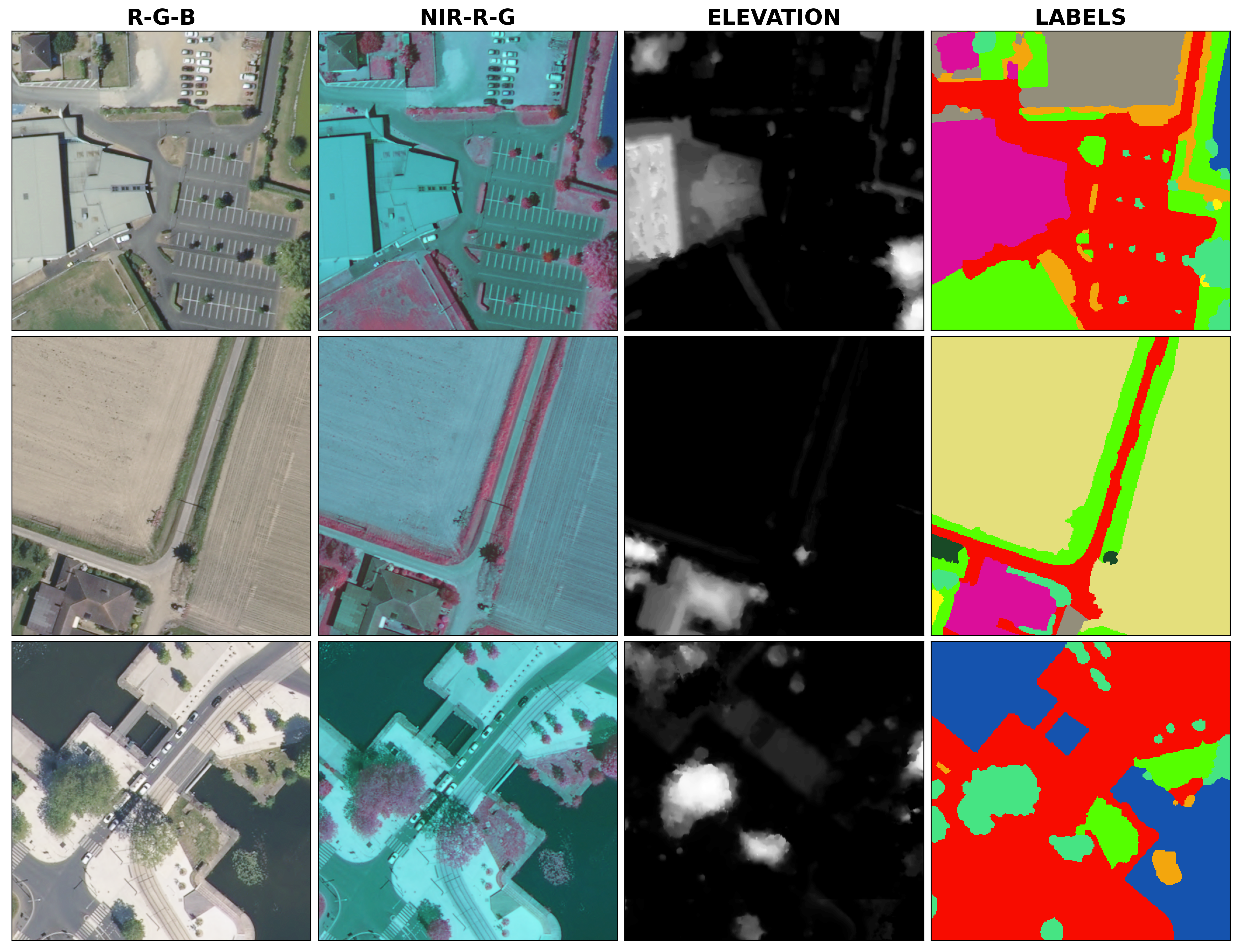
The FLAIR #1 dataset is sampled countrywide and is composed of over 20 billion annotated pixels, acquired over three years and different months (spatio-temporal domains). The dataset is available to download here. It consists of 512 x 512 patches with 13 (baselines) or 19 (full) semantic classes (see associated datapaper). Each patch has 5 channels (RVB-Infrared-Elevation).
ORTHO HR® aerial image cover of France (left), train and test spatial domains of the dataset (middle) and acquisition months defining temporal domains (right).

Example of input data (first three columns) and corresponding supervision masks (last column).
A U-Net architecture with a pre-trained ResNet34 encoder from the pytorch segmentation models library is used for the baselines. The used architecture allows integration of patch-wise metadata information and employs commonly used image data augmentation techniques. It has about 24.4M parameters and it is implemented using the segmentation-models-pytorch library. The results are evaluated with an Intersection Over Union (IoU) metric and a single mIoU is reported (see associated datapaper).
The metadata strategy refers encoding metadata with a shallow MLP and concatenate this encoded information to the U-Net encoder output. The augmentation strategy employs three typical geometrical augmentations (see associated datapaper).
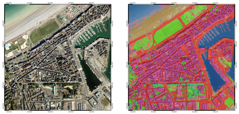
Example of a semantic segmentation of an urban and coastal area in the D076 spatial domain, obtained with the baseline trained model:

Example of a semantic segmentation result using the baseline model.
The flair-1-config.yml file controls paths, hyperparameters and computing ressources. The file requirement.txt is listing used libraries for the baselines.
To launch a training/inference/metrics computation, you can either use :
-
main.py --config_file=flair-1-config.yml -
use the
flair-one-baseline.ipynbnotebook guiding you through data visualization, training and testing steps.
A toy dataset (reduced size) is available to check that your installation and the information in the configuration file are correct.
| Model | mIoU |
|---|---|
| baseline U-Net (ResNet34) | 0.5443±0.0014 |
| baseline U-Net (ResNet34) + metadata + augmentation | 0.5570±0.0027 |
If you want to submit a new entry, you can open a new issue. Results of the challenge will be reported soon!
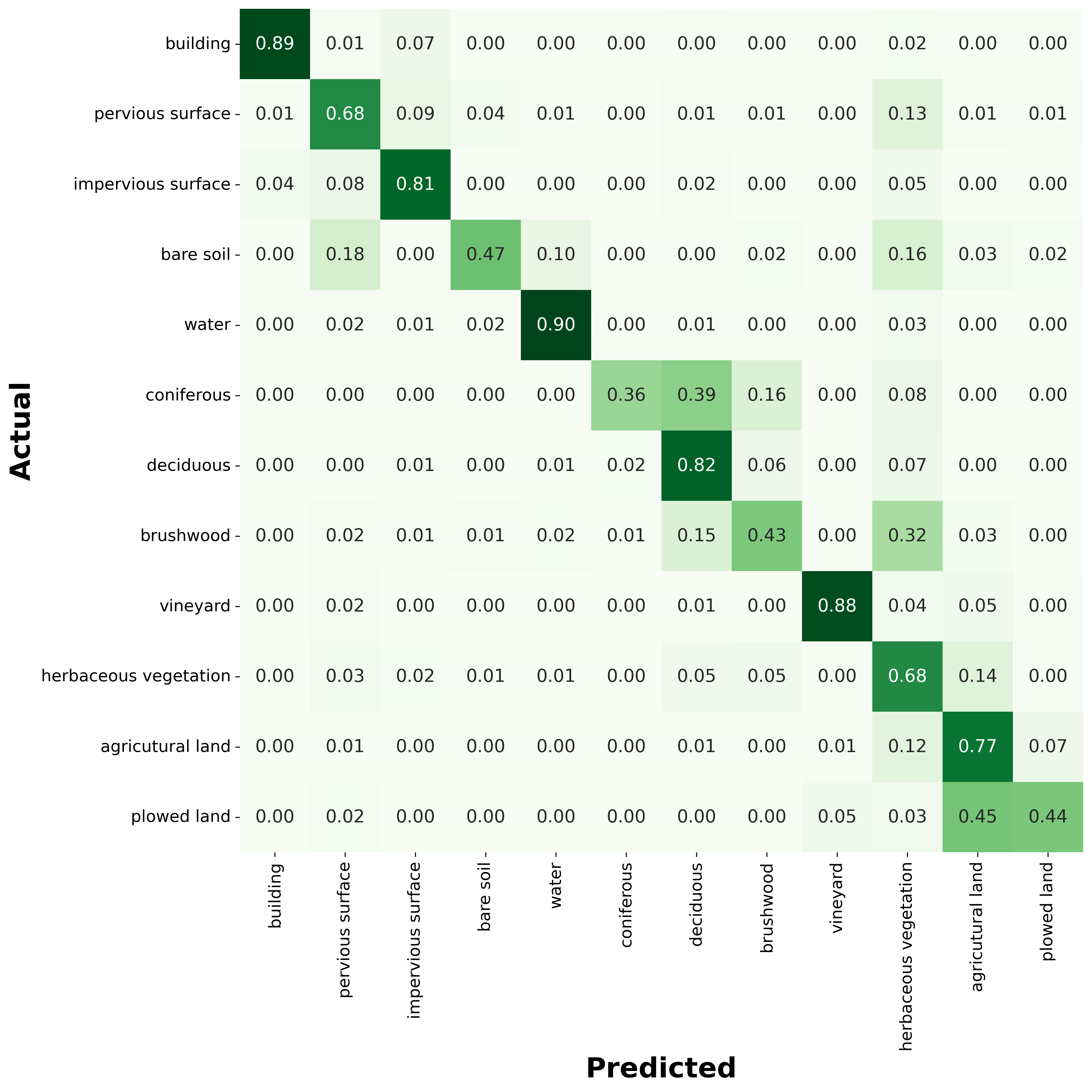
The baseline U-Net with ResNet34 backbone obtains the following confusion matrix:

Baseline confusion matrix of the test dataset normalized by rows.
Please include a citation to the following article if you use the FLAIR #1 dataset:
@article{garioud2022flair1,
  doi = {10.13140/RG.2.2.30183.73128/1},
  url = {https://arxiv.org/pdf/2211.12979.pdf},
  author = {Garioud, Anatol and Peillet, Stéphane and Bookjans, Eva and Giordano, Sébastien and Wattrelos, Boris},
  title = {FLAIR #1: semantic segmentation and domain adaptation dataset},
  publisher = {arXiv},
  year = {2022}
}
This work was performed using HPC/AI resources from GENCI-IDRIS (Grant 2022-A0131013803).

