GeoForumlas is a collection of ellipsoid formulas, written in C++, that are based on the formulas found in Appendix 2 of FAA document Order 8260.54A.
Algorithms and methods are described for calculating geodetic locations (latitudes and longitudes) on the World Geodetic System of 1984 (WGS-84) ellipsoid, resulting from intersections of geodesic and non-geodesic paths. These algorithms utilize existing distance and azimuth calculation methods to compute intersections and tangent points needed for area navigation procedure construction. The methods apply corrections to an initial spherical approximation until the error is less than the maximum allowable error, as specified by the user.
GeoFormulas can now be built as a DLL or statically linked library. VBA macros for Microsoft Excel are also included in the directory, which allows full usage of the GeoFormulas API via the DLL. See the bottom of GeoExcelStub.cls for examples using the API.
GeoFormulas has some dependency on the STL. The version that comes with MSVC 7.1 and 8.0 are sufficient to build the GeoFormulas library.
WGS84 Ellipsoid Calculation Types
Arc Intercept             Geodesic Locus Intersect            Point on LocusP
Course Intersect          Geometric Mean Meridional           Point to Arc Tangents
Direct Arc Length         Locus Arc Intersect                 Pt is on Arc
Discretized Arc Length    Locus Course at Point               Pt is on Geodesic
Distance Intersection     Locus Intersect                     Pt is on Locus
Distance to LocusP        Locus Perpendicular Intercept       Tangent Fixed Radius Arc
Distance to LocusD        Locus Tangent Fixed Radius Arc      Vincenty Direct
ECEF                      Perpendicular Intercept             Vincenty Inverse
Geodesic Arc Intercept    Perpendicular Tangent Points
TerpsTest is a test harness driven by GeoFormulas. The test data and expected results are published in FAA Order 8260.54A Appendix 2, Attachment C.
The goal of the test harness is to have a solid set of test data and expected results to run against the GeoFormulas. A great deal of effort was put into creating the test suite and to get the results within expected tolerances.
The directory 8260.54ATestData contains CSV test data used by TerpsTest. This data was scraped from the 8260_54A.pdf in Appendix 2, attachment C. 8260.54a Test Data Origin.txt contains details of history and how the data was collected. If any changes to the test data are made then update this document too.
Application test Results.txt is an implementation log tracking some my thoughts. The code comments and this document will help document how and why certain things are implemented, in order to get the expected test results.
TerpsTest is heavily dependent on C++11 std::regex to parse the CSV test data. Compilers which support C++11 std::regex are, GCC 4.9+, Clang 3.3+, and possibly VS 2012+ (current testing is done on VS 2015).
All calculations are performed on a WGS84 ellipsoid. The input and output is done in the following units -
- Latitudes and Longitudes - HDMS: N23 12 06.3227, N23.12.06.3227, 23 12 06.3227N, 23.12.06.3227N, are all examples of the same input value. After input validation the input is transformed and stored internally as a double. Outputs are shown in HDD MM SS.ss
- Distances: Input units are Meters, Nautical Miles, and Feet. Internally the input is converted and stored in meters. Output units can be meters, NM, or feet.
- Bearings, angles, and azimuths: Inputs are in DD.ddd decimal degrees. Internally the input is converted and stored as radians. Output is always decimal degrees.
Input: Pt1, Pt2
Output: Crs12, Dist12
Input: Pt1, Crs12, and Dist12
Output: Pt2
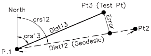
Input: Geodesic defined by Pt1 and Pt2 Test Pt3
Output:
True if Pt3 is on geodesic, false otherwise.
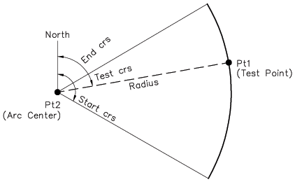
Input: Test Pt1 Pt2 - Center of arc Start azimuth End azimuth Arc radius Arc direction
Output:
True if Pt1 is on arc, false otherwise.
Input: Test Pt1 - Center of Arc Start azimuth End azimuth Arc radius Arc direction Number of Segments (1 - 32)
Output: Computed direct arc length Computed discretized arc length
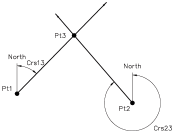
Input: Pt1 Crs13 Pt2 Crs23
Output:
Pt3
Dist13, Az31
Dist23, Az32
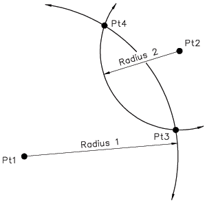
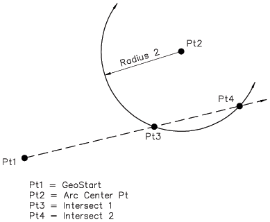
Input: Pt1 - Center pt of arc 1 Arc 1 radius Pt2 - Center pt of arc 2 Arc 2 radius
Output:
Pt3 - Intersection 1
Pt4 - Intersection 2
Input: Pt1 Bearing (azimuth) Pt2 - Center pt of arc 1 Arc 2 radius
Output:
Pt3 - Intercept 1
Pt4 - Intercept 2
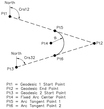
Input: Pt1 Bearing (azimuth 12) Pt3 Bearing (azimuth 32) Arc radius
Output:
Pt4 - Arc center
Pt5 - Tangent start point
Pt6 - Tangent end point
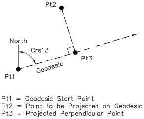
Input: Pt1 Bearing (azimuth) Pt2
Output:
Pt3 - Intercept point
Dist13
Az13
Dist23
Az23
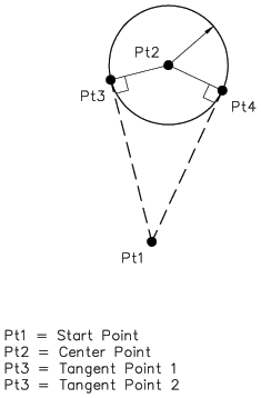
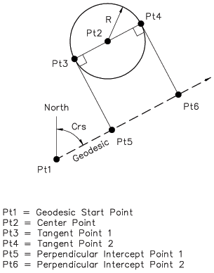
Input: Pt1 Pt2 - Arc center point Arc radius
Output:
Pt3 - Tangent point 1
Pt4 - Tangent point 2
Input: Pt1 Azimuth Pt2 - Arc center point Arc radius
Output:
Pt3 - Tangent point 1
Pt4 - Tangent point 2
Pt5 - Intercept point 1
Pt6 - Intercept point 2
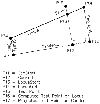
Input: Pt5 - Test point Locus definition Pt1 - Geodesic start point Pt2 - Geodesic end point Start point offset - locus start point Pt3 End point offset - locus end point Pt4
Output:
True if Pt5 is on locus between Pt3 and Pt4, false otherwise.
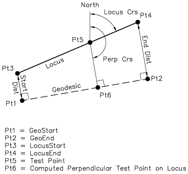
Input: Pt1 - Geodesic start point Pt2 - Geodesic end point Pt5 - Point on locus (geodesic offset point) Bearing - Locus bearing
Output:
Pt3 - Locus start point
Pt4 - Locus end point
Dist13
Dist24
Pt6 - Pt5 projected perpendicular onto geodesic
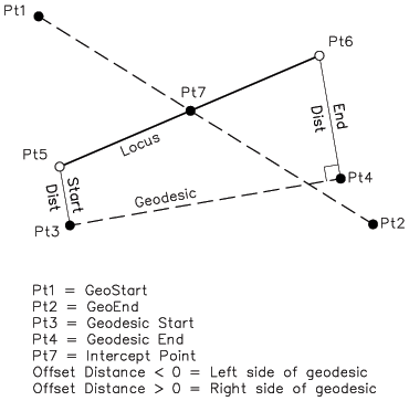
Input: Pt1 - Geodesic start point Pt2 - Geodesic end point Locus definition Pt3 - Geodesic start point Pt4 - Geodesic end point Start point offset - locus start point Pt5 End point offset - locus end point Pt6
Output:
Pt5 - Locus start point
Pt6 - Locus end point
Dist35
Dist46
Pt7 - Intercept point on locus
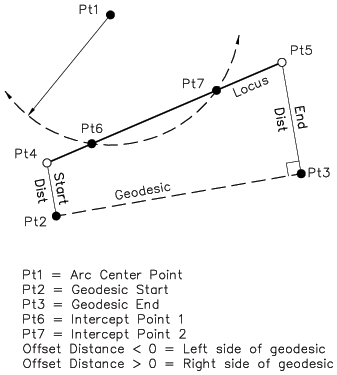
Input: Pt1 - Center point of arc Arc radius Locus definition Pt2 - Geodesic start point Pt3 - Geodesic end point Dist24 - locus start point Pt4 Dist35 - locus end point Pt5
Output:
Pt4 - Locus start point
Pt5 - Locus end point
Pt6 - Arc intercept point 1 on locus
Pt7 - Arc intercept point 2 on locus
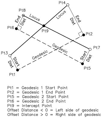
Input: Locus 1 definition Pt1 - Geodesic start point Pt2 - Geodesic end point Dist13 dist 24 Locus 2 definition Pt5 - Geodesic start point Pt6 - Geodesic end point Dist57 Dist68
Output:
Locus 1
Pt3 - Locus start point
Pt4 - Locus end point
Locus 2
Pt7 - Locus start point
Pt8 - Locus end point
Pt9 - Intercept of locus 1 and locus 2
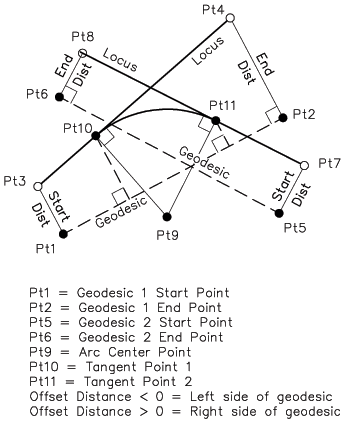
Input: Arc Radius Locus 1 definition Pt1 - Geodesic start point Pt2 - Geodesic end point Dist13 dist 24 Locus 2 definition Pt5 - Geodesic start point Pt6 - Geodesic end point Dist57 Dist68
Output:
Locus 1
Pt3 - Locus start point
Pt4 - Locus end point
Locus 2
Pt7 - Locus start point
Pt8 - Locus end point
Pt9 - Intercept of locus 1 and locus 2
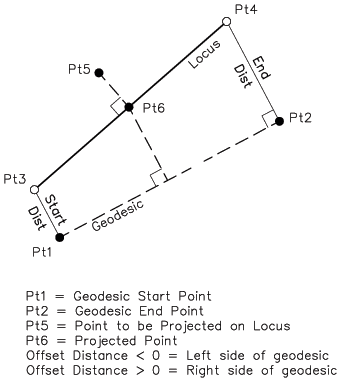
*Input:* Pt5 - Point to project onto locus Locus 1 definition Pt1 - Geodesic start point Pt2 - Geodesic end point Dist13 dist 24
Output:
Pt3 - Locus start point
Pt4 - Locus end point
Pt6 - Pt projected onto locus
Licensed under the Apache License, Version 2.0 (the "License");
you may not use this software except in compliance with the License.
You may obtain a copy of the License at

  http://www.apache.org/licenses/LICENSE-2.0

Unless required by applicable law or agreed to in writing, software
distributed under the License is distributed on an "AS IS" BASIS,
WITHOUT WARRANTIES OR CONDITIONS OF ANY KIND, either express or implied.
See the License for the specific language governing permissions and
limitations under the License.
Which basically means: whatever you do, I can't be held accountable if something breaks.
