- July/2024 - Our paper is accepted by IEEE Trans. Intell. Transp. Syst. [paper].
- 23/April/2024 - We have revised and updated version 2 of the paper.
- 19/April/2024 - We have fixed the problem of TypeError: can't pickle xxxx objects in code.
- 17/April/2024 - We fixed the code problem in 3D-2D projection of RoadBEV-stereo.
This is the implementation of the work: RoadBEV: Road Surface Reconstruction in Bird’s Eye View.
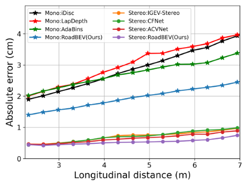
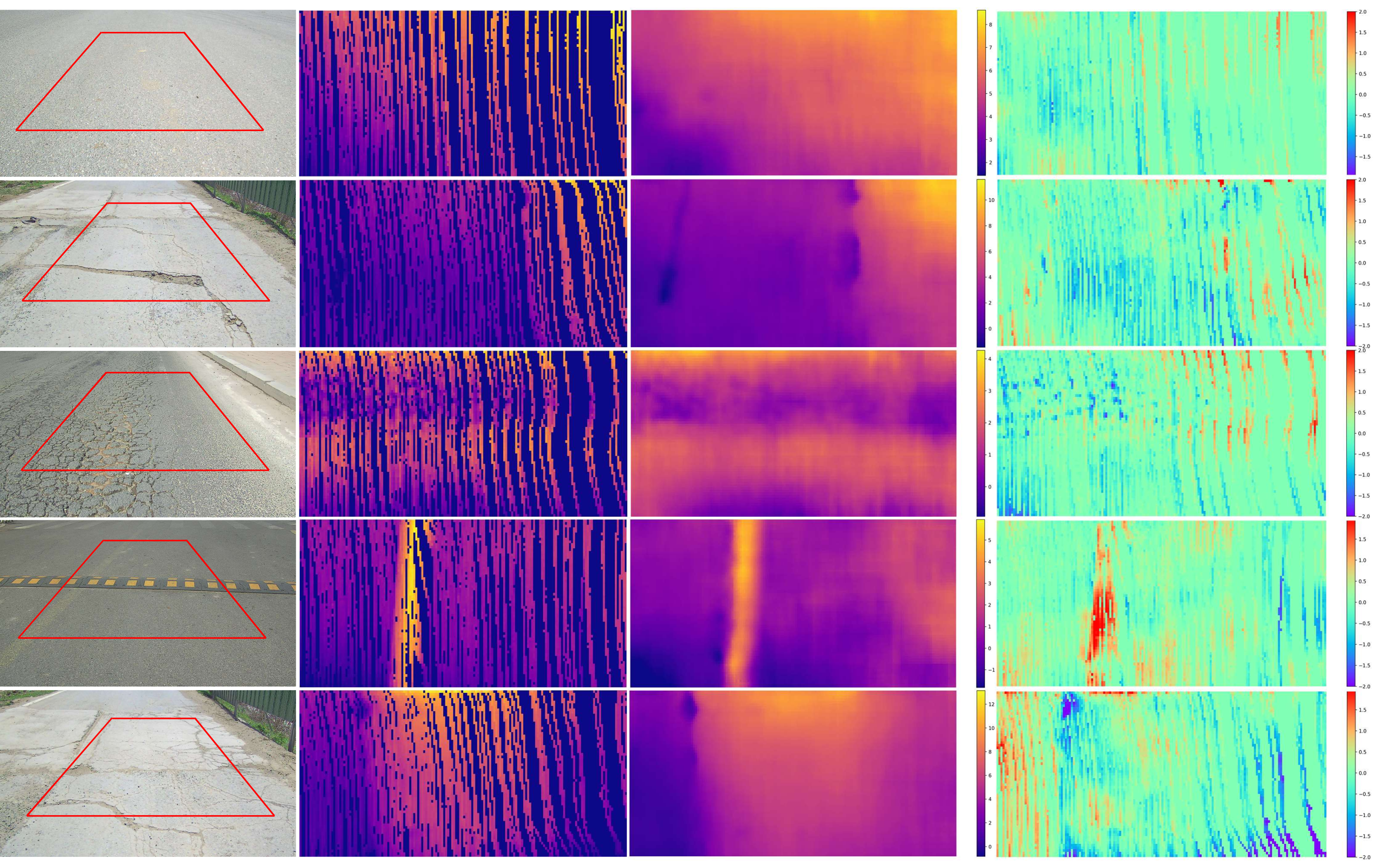
Road surface reconstruction, an essential task for autonomous driving comfort control, suffers from poor performance in perspective view. We propose RoadBEV-mono and RoadBeV-stereo, which reconstruct road surface with monocular and stereo images in Bird's Eye View, respectively.
We use Road Surface Reconstruction Dataset (RSRD). The GT elevation maps should be generated off-line, as it costs much computation. The dataset used here is extracted from trainset of RSRD-dense. We split it into train (1210) and test (371) sets. You can split some from the train set for validation. The samples' info (including path, pose, location) are stored in pkl files in the filenames folder of this repo.
-
First, download RSRD (the dense subset of 15.1GB) and the calibration files in dev kit. Set the corresponding path in dataset.py.
-
Generate and save the GT maps to local. The GT maps depend on ROI and horizontal resolution. We do not recommend changing the related parameters in dataset.py, as they are determined based on statistic analysis on the dataset. Changes on them may lead to errors and inconsistent results. If you do change, re-generate corresponding GT.
python preprocess_gt.py --save_dir '/data/preprocessed/' --dataset 'train'
python preprocess_gt.py --save_dir '/data/preprocessed/' --dataset 'test'
The elevation maps along with masks are saved in .pkl format. For convenience, you can also directly download generated GT labels here.
Note
- Further, we provide the info for all samples in the RSRD-dense, which contains 2430 training and 296 testing samples download.
- The sample info for RSRD-sparse is also available, containing 13K samples download. It has very sparse GT point cloud labels, which can be used for pretraining or unsupervised learning.
- The provided small dataset in this work is just an example, as we focus more on the feasibility of the pipeline. Reserachers can also build larger train/test sets with the provided data.
The directories should be like:
RoadBEV
├── utils
│   └── dataset.py
├── filenames
│   ├── train
│   │    ├── 20230317074852.000.pkl
│   │    └── ...
│   ├── test
│   │    ├── 20230317075641.200.pkl
│   │    └── ...
├── train.py
├── test.py
└── preprocess_gt.py

RSRD-dense
├── train
│   ├── 2023-03-17-07-48-37
│   │    ├── left_half
│   │    ├── right_half
│   │    ├── pcd
│   │    └── ...
│   ├── 2023-03-21-07-36-59
│   └──...

preprocessed
├── train
│   ├── 20230409021332.400.pkl
│   └── ...
├── test
│   ├── 20230409015836.600.pkl
│ └── ...- Python 3.7
- Pytorch 1.10.0
- open3d 0.16.0
conda create -n roadbev python=3.7
conda activate roadbev
conda install pytorch=1.10.0 torchvision torchaudio cudatoolkit=11.1 -c pytorch -c nvidia
conda install -c open3d-admin open3d
pip install opencv-python
pip install pillow
Use the following command to train RoadBEV-mono:
python train.py --lr 8e-4
Use the following command to train RoadBEV-stereo:
python train.py --stereo --lr 5e-4
python test.py --loadckpt 'xxx.ckpt'  # test RoadBEV-mono
python test.py --stereo --loadckpt 'xxx.ckpt'  # test RoadBEV-stereo
| Method | Abs. err. (cm) | RMSE | >0.5cm (%) |
|---|---|---|---|
| LapDepth | 2.81 | 3.12 | 85.3 |
| PixelFormer | 2.65 | 2.86 | 82.0 |
| iDisc | 2.64 | 2.88 | 84.3 |
| AdaBins | 2.59 | 2.79 | 82.4 |
| RoadBEV-mono(Ours) | 1.83 | 2.07 | 78.6 |
| Method | Abs. err. (cm) | RMSE | >0.5cm (%) |
|---|---|---|---|
| IGEV-Stereo | 0.651 | 0.797 | 49.5 |
| PSMNet | 0.654 | 0.785 | 50.1 |
| CFNet | 0.647 | 0.760 | 50.8 |
| ACVNet | 0.596 | 0.723 | 46.2 |
| GwcNet | 0.588 | 0.711 | 44.9 |
| DVANet | 0.546 | 0.685 | 40.9 |
| RoadBEV-stereo(Ours) | 0.503 | 0.609 | 37.0 |
Visualize the inference results saved as .pkl files in test.py:
python visualization.py
This is the very initial exploration of reconstructing road surface in BEV. Future research can be improved in many aspects like:
- More accuract 3D-2D BEV query indexing, with spatial cross-attention...
- Using sparse representation. We define dense candidate voxels and then query features. Sparse road scene encoding may help.
- Utilizing sequence information with temporal attention. The provided dataset filenames have some continuous sequences.
- More advanced backbone. Introducting attention mechanism, transformer...
- Classification with offsets. We regress elevation values with soft argmin(weighted sum of bins). Peak class with offset can also be adopted.
- More efficient estimation head. For RoadBEV-stereo, the 3D convs cost much computation. More strategies can be explored.
- Utilizing the RSRD-sparse. It contains much more samples, which will greatly enhance model generalization capability. Samples in it can also be used for visualization and inference.
- Our previous research DVANet, which reconstructs road surface with direct stereo matching, may provide valuable insights.
If you find this project helpful in your research, please cite the papers below.
@ARTICLE{RoadBEV_tongzhao,
  author={Zhao, Tong and Yang, Lei and Xie, Yichen and Ding, Mingyu and Tomizuka, Masayoshi and Wei, Yintao},
  journal={IEEE Transactions on Intelligent Transportation Systems},
  title={RoadBEV: Road Surface Reconstruction in Bird’s Eye View},
  year={2024},
  volume={},
  number={},
  pages={1-12},
  doi={10.1109/TITS.2024.3431671}}

@article{rsrd_tongzhao,
  title={A road surface reconstruction dataset for autonomous driving},
  author={Zhao, Tong and Xie, Yichen and Ding, Mingyu and Yang, Lei and Tomizuka, Masayoshi and Wei, Yintao},
  journal={Scientific data},
  volume={11},
  number={1},
  pages={459},
  year={2024}}


