This repository offers a concise collection of Python code snippets tailored for use with the Habitat environment [1].
I wrote these snippets during my exploration of the Habitat environment.
The included code covers various functionalities, such as constructing semantic maps, occupancy maps, or topological maps within a Matterport environment.
Additionally, you can utilize the Habitat simulator to obtain panoramic views from any specified location.
My aim is for these snippets to serve as a valuable resource for others exploring the Habitat environment.
| Tools | Initial Code | Code Cleanup | Documentation | |
|---|---|---|---|---|
| 1 | demo: build a semantic map | ✔️ | ✔️ | ✔️ |
| 2 | demo: build an occupancy map | ✔️ | ✔️ | ✔️ |
| 3 | demo: get a panoramic view at given map coordinates | ✔️ | ✔️ | ✔️ |
| 4 | code: get category to index mapping | ✔️ | ✔️ | ✔️ |
| 5 | demo: build semantic map at any height via cutting the point cloud | ✔️ | ✔️ | ✔️ |
| 6 | demo: build a topological map | ✔️ | ✔️ | ✔️ |
We use python==3.7.
We recommend using a conda environment.
conda create --name habitat_py37 python=3.7
source activate habitat_py37
You can install Habitat-Lab and Habitat-Sim following instructions here.
We recommend installing Habitat-Lab and Habitat-Sim from the source code.
We use habitat==0.2.1 and habitat_sim==0.2.1.
Use the following commands to set it up:
# install habitat-lab
git clone --branch stable https://github.com/facebookresearch/habitat-lab.git
cd habitat-lab
git checkout tags/v0.2.1
pip install -e .

# install habitat-sim
git clone --recurse --branch stable https://github.com/facebookresearch/habitat-sim.git
cd habitat-sim
pip install -r requirements.txt
sudo apt-get update || true
# These are fairly ubiquitous packages and your system likely has them already,
# but if not, let's get the essentials for EGL support:
sudo apt-get install -y --no-install-recommends \
     libjpeg-dev libglm-dev libgl1-mesa-glx libegl1-mesa-dev mesa-utils xorg-dev freeglut3-dev
git checkout tags/v0.2.1
python setup.py install --with-cuda
Download scene dataset of Matterport3D(MP3D) from here.
Upzip the scene data and put it under habitat-lab/data/scene_datasets/mp3d.
You are also suggested to download task dataset of Point goal Navigation on MP3D from here
Unzip the episode data and put it under habitat-lab/data/datasets/pointnav/mp3d.
Create soft links to the data.
cd  bellman_point_goal
ln -s habitat-lab/data data
The code requires the datasets in data folder in the following format:
habitat-lab/data
  └── datasets/pointnav/mp3d/v1
       └── train
       └── val
       └── test
  └── scene_datasets/mp3d
        └── 1LXtFkjw3qL
        └── 1pXnuDYAj8r
        └── ....
python demo_1_build_semantic_BEV_map.py
This demo builds a top-down-view semantic map of the target scene at a specified height (y value of the robot base) by,
- initialize a dense grid with a cell size equal to 30cm of the real-world environment.
- densely render observations (RGB, depth, and semantic segmentation) at each cell's location with eight viewpoint angles.
- initialize a grid map with cell size equal to 5cm of the real-world environment
- project semantic segmentation pixels to a 3D point cloud using the depth map and robot pose.
- discretize the point cloud into a voxel grid and take the top-down view of the voxel grid
- the semantic map depends on the majority category of the points located at the top grid of each cell.
The demo outputs a currently maintained map after every 1000 steps.

The built semantic map helps you view the entire scene and generate ObjectNav [2] tasks yourself.
python demo_2_build_occupancy_map.py
This demo builds an occupancy map of the target scene at a specified height (y value of the robot base) on the top of the pre-built semantic map.
The occupancy map and the semantic map share the same width and height.
The demo builds the occupancy map by,
- initialize a dense grid with a cell size equal to 5cm of the real-world environment.
- go through each cell and use
habitat_env.is_navigable()to check if a cell is free. - convert each cell's pose to the coordinates on the map and mark the corresponding map cell with a value of
1(free) or0(occluded).
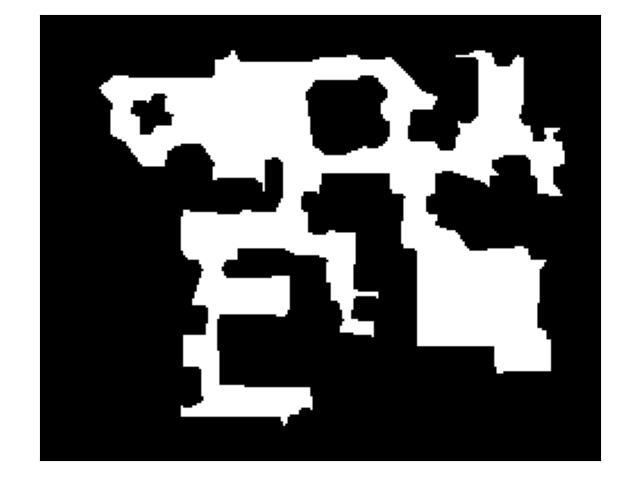
The demo outputs an occupancy map that looks like this.

python demo_3_get_panorama_at_given_location.py
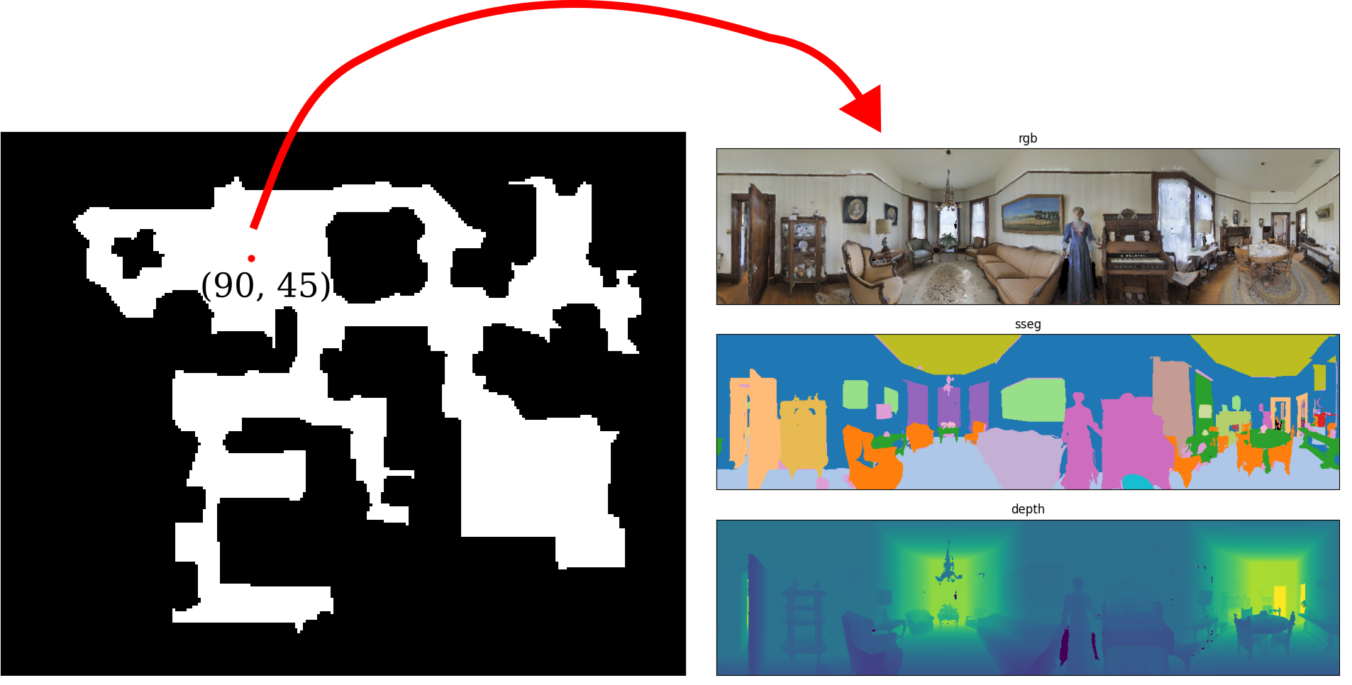
With the built occupancy map, this demo renders a panorama at a given location (coordinates (90, 45) on the map).

The idea is to render four views at the given location and stitch the views to form the panorama.
python demo_4_get_cat2idx_mapping.py
This demo shows how to retrieve the mapping between the Matterport3D categories and indexes.
dict_cat2idx = {'void': 0, 'wall': 1, 'floor': 2, 'chair': 3, 'door': 4, 'table': 5, 'picture': 6, 'cabinet': 7, 'cushion': 8, 'window': 9, 'sofa': 10, 'bed': 11, 'curtain': 12, 'chest_of_drawers': 13, 'plant': 14, 'sink': 15, 'stairs': 16, 'ceiling': 17, 'toilet': 18, 'stool': 19, 'towel': 20, 'mirror': 21, 'tv_monitor': 22, 'shower': 23, 'column': 24, 'bathtub': 25, 'counter': 26, 'fireplace': 27, 'lighting': 28, 'beam': 29, 'railing': 30, 'shelving': 31, 'blinds': 32, 'gym_equipment': 33, 'seating': 34, 'board_panel': 35, 'furniture': 36, 'appliances': 37, 'clothes': 38, 'objects': 39, 'misc': 40}
dict_idx2cat = {0: 'void', 1: 'wall', 2: 'floor', 3: 'chair', 4: 'door', 5: 'table', 6: 'picture', 7: 'cabinet', 8: 'cushion', 9: 'window', 10: 'sofa', 11: 'bed', 12: 'curtain', 13: 'chest_of_drawers', 14: 'plant', 15: 'sink', 16: 'stairs', 17: 'ceiling', 18: 'toilet', 19: 'stool', 20: 'towel', 21: 'mirror', 22: 'tv_monitor', 23: 'shower', 24: 'column', 25: 'bathtub', 26: 'counter', 27: 'fireplace', 28: 'lighting', 29: 'beam', 30: 'railing', 31: 'shelving', 32: 'blinds', 33: 'gym_equipment', 34: 'seating', 35: 'board_panel', 36: 'furniture', 37: 'appliances', 38: 'clothes', 39: 'objects', 40: 'misc'}
In each episode of the navigation tasks, be it PointGoal, ObjectGoal, or Vision-Language-Navigation (VLN), the robot starts at a particular height within a specific environment.
Building a semantic map for the same environment but at different heights would be redundant.
To streamline this process, we adopt a more efficient approach by cutting the point cloud to construct a semantic map online according to the episode's height.
In this demo, let's use the VLN task as an example.
- Download task dataset of VLN on MP3D here.
- Unzip the episode data and put it under
habitat-lab/data/datasets/vln_r2r_mp3d_v1.
You can obtain the point cloud data by either exploring the environment yourself or by downloading a pre-collected dataset, as provided by here, which is pre-collected by [[3]].(#references).
3. After you download the point cloud, unzip and put it under habitat-lab/data/other_datasets/mp3d_scene_pclouds.
The code requires the datasets in the data folder in the following format:
habitat-lab/data
                /datasets/pointnav
                /datasets/vln_r2r_mp3d_v1
                                         /train
                                         /val_seen
                                         /val_unseen
                /other_datasets/mp3d_scene_pclouds
                                                  /1LXtFkjw3qL_color.npz
                                                  /1LXtFkjw3qL_pcloud.npz
                                                  /1pXnuDYAj8r_color.npz
                                                  /1pXnuDYAj8r_pcloud.npz
To run the demo
python demo_5_build_semantic_map_via_point_cloud.py
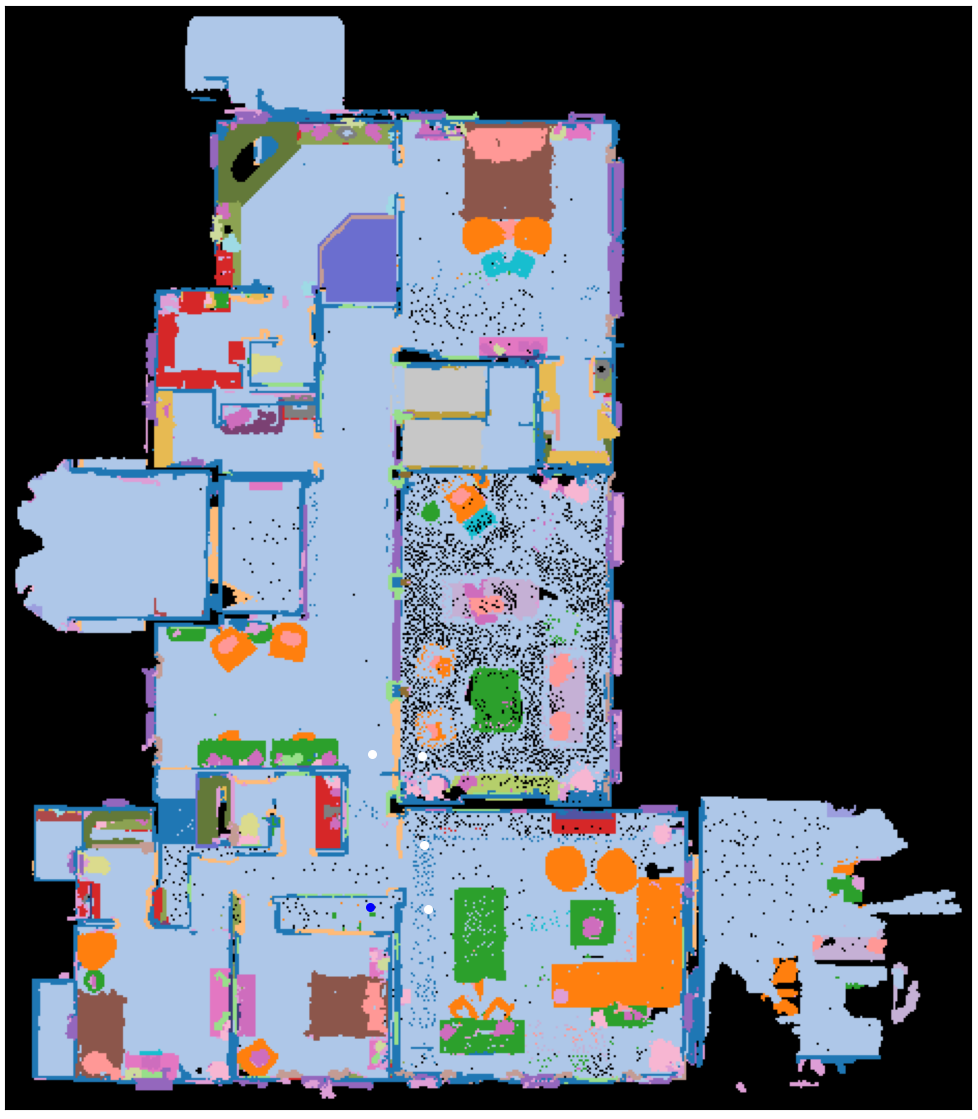
This demo builds a semantic map at the height of y at an environment specified in a VLN episode.
The white circles denote the waypoints.
python demo_6_build_topological_map.py
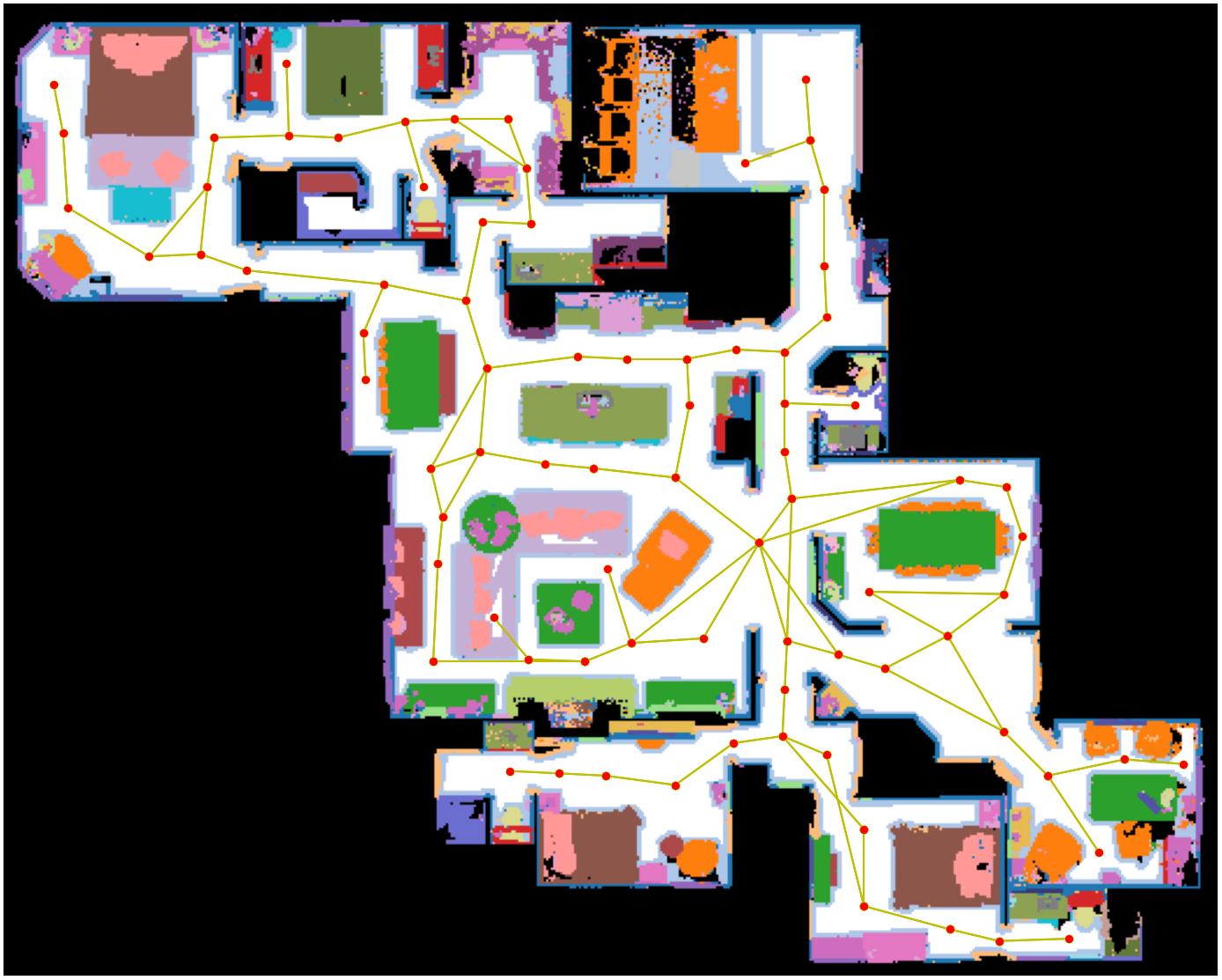
This demo builds a topological map of the target scene at a specified height (y value of the robot base) on top of the pre-built semantic and occupancy map.
- Find the largest connected component of the environment
- Compute skeleton on the largest connected component (so there is no dangling node that is not reachable to any other nodes.)
- Remove skeleton nodes near each other.
I developed this repo while I worked on the following papers.
If you find this code useful, please consider citing them.
@inproceedings{li2022comparison,
  title={Comparison of Model Free and Model-Based Learning-Informed Planning for PointGoal Navigation},
  author={Yimeng Li and Arnab Debnath and Gregory J. Stein and Jana Kosecka},
  booktitle={CoRL 2022 Workshop on Learning, Perception, and Abstraction for Long-Horizon Planning},
  year={2022},
  url={https://openreview.net/forum?id=2s92OhjT4L}
}

@article{Li2022LearningAugmentedMP,
  title={Learning-Augmented Model-Based Planning for Visual Exploration},
  author={Yimeng Li and Arnab Debnath and Gregory J. Stein and Jana Kosecka},
  booktitle={IEEE/RSJ International Conference on Intelligent Robots and Systems (IROS)},
  year={2023}
}
[1] Savva, M., Kadian, A., Maksymets, O., Zhao, Y., Wijmans, E., Jain, B., ... & Batra, D. (2019). Habitat: A platform for embodied ai research. In Proceedings of the IEEE/CVF international conference on computer vision (pp. 9339-9347). https://github.com/facebookresearch/habitat-lab
[2] Ramakrishnan, S.K., Chaplot, D.S., Al-Halah, Z., Malik, J., & Grauman, K. (2022). PONI: Potential Functions for ObjectGoal Navigation with Interaction-free Learning. 2022 IEEE/CVF Conference on Computer Vision and Pattern Recognition (CVPR), 18868-18878.
[3] Georgakis, G., Schmeckpeper, K., Wanchoo, K., Dan, S., Miltsakaki, E., Roth, D., & Daniilidis, K. (2022). Cross-modal map learning for vision and language navigation. In Proceedings of the IEEE/CVF Conference on Computer Vision and Pattern Recognition (pp. 15460-15470). https://github.com/ggeorgak11/CM2


