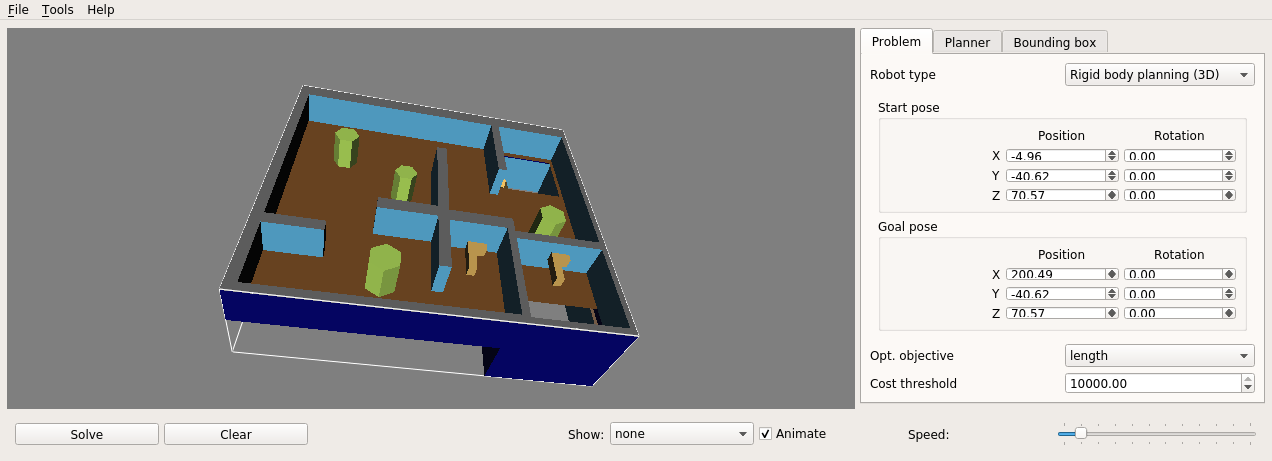
By default OMPL demo is using 3D/cubicles_env.dae for the environment and 3D/cubicles_robot.dae for the robot. You could specify other params via command line.
python3 /ompl_demo/src/ompl_demo_cartesian.py --help

usage: ompl_demo_cartesian.py [-h] [--start START [START ...]] --goal GOAL
                              [GOAL ...] [--output_file_path OUTPUT_FILE_PATH]
                              [--env_mesh_path ENV_MESH_PATH]
                              [--robot_mesh_path ROBOT_MESH_PATH]

OMPL demo for Cartesian coordinate system

optional arguments:
  -h, --help            show this help message and exit
  --start START [START ...]
                        Start point in a format `x, y, z` in meters
  --goal GOAL [GOAL ...]
                        Goal point in a format `x, y, z` in meters
  --output_file_path OUTPUT_FILE_PATH
                        Path to a .txt file for further visualization
  --env_mesh_path ENV_MESH_PATH
                        Path to environement .dae file
  --robot_mesh_path ROBOT_MESH_PATH
                        Path to robot .dae file
python3 /ompl_demo/src/ompl_demo_geodetic.py --help
usage: ompl_demo_geodetic.py [-h] [--start START [START ...]] --goal GOAL
[GOAL ...] [--output_file_path OUTPUT_FILE_PATH]
[--env_mesh_path ENV_MESH_PATH]
[--robot_mesh_path ROBOT_MESH_PATH]
OMPL demo for Geodetic coordinate system
optional arguments:
-h, --help show this help message and exit
--start START [START ...]
Start point in a format `lat, lon, alt`
--goal GOAL [GOAL ...]
Goal point in a format `lat, lon, alt`
--output_file_path OUTPUT_FILE_PATH
Path to a .txt file for further visualization
--env_mesh_path ENV_MESH_PATH
Path to environement .dae file
--robot_mesh_path ROBOT_MESH_PATH
Path to robot .dae file- Cartesian coordinate system:
python3 /ompl_demo/src/ompl_demo_cartesian.py \
    --start -4.96 -40.62 70.57 \
--goal 200.49 -40.62 70.57- Geodetic coordinate system:
python3 /ompl_demo/src/ompl_demo_geodetic.py \
--goal -83.77534490949962 -55.690830378508565 2403.460302218876Steps to build and run docker image:
- Build an image:
cd <ompl_demo_repo>/docker/bionic
./build.bash- Run
dockercontainer ( with X server communication available ):
cd <ompl_demo_repo>/docker/bionic
./run.bashThe result of the ompl_demo_geodetic.py or ompl_demo_cartesian.py is a text file with path inside of it ( e.g. path to the file is specified by output_file_path. It can be viewed by using OMPL app.
Inside the docker container run:
python3 /ompl_demo/src/ompl_demo_cartesian.py \
    --start -4.96 -40.62 70.57 \
    --goal 200.49 -40.62 70.57
It will generate /ompl_demo/path.txt, to preview it run:
ompl_appThen:
- Add environment from
/ompl/omplapp-1.5.2-Source/resources/3D/cubicles_env.dae; - Add robot from
/ompl/omplapp-1.5.2-Source/resources/3D/cubicles_robot.dae; - Add genereted path
/ompl_demo/path.txt; - Result:
