Terra is a flexible and abstracted grid world environment for training intelligent agents in the context of earthworks planning. It makes it possible to approach motion and excavation high-level planning as a reinforcement learning problem, providing a multi-GPU JAX-accelerated environment. We show that we can train an agent capable of planning earthworks in trenches and foundations environments in less than 1 minute on 8 Nvidia RTX-4090 GPUs.
- 🚜 Two Agent Types: Wheeled and tracked excavator embodiments for different types of actions
- 🏞️ Realistic Maps: Up-to-3-axes trenches and building foundations with obstacles and dumping constraints
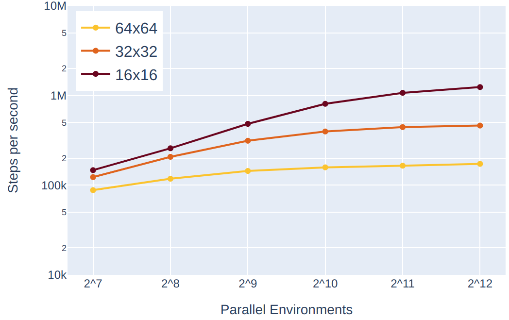
- 🔥 Performance: Easily scale to more than 1M steps per second on a single GPU
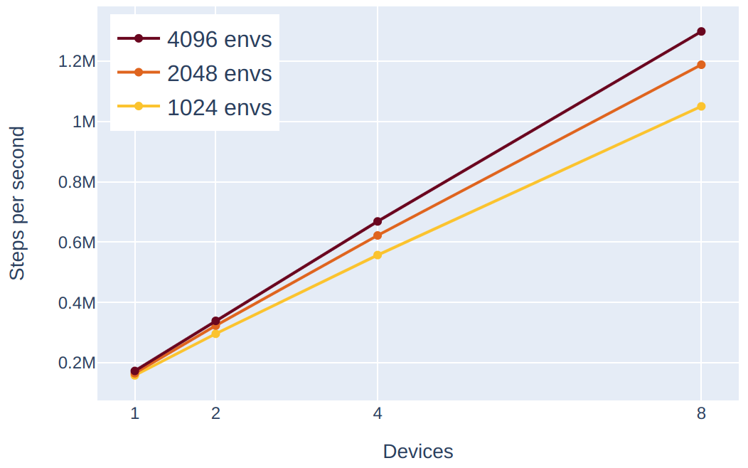
- 🚀 Scaling: Out of the box multi-device training
- 📖 Curriculum: Customizable RL curriculum via config interface
- 🔧 Tooling: Visualization, evaluation, manual play, and maps inspection scripts
- 🏌 Baselines: We provide baseline results and PPO-based training scripts inspired from purejaxrl and xland-minigrid
Clone the repo, and if you want to use Terra in your project use
pip install -e .
You can check out terra-baselines for an installation workflow example.
The JAX installation is hardware-dependent and therefore needs to be done separately. Follow this link to install the right one for you.
The standard workflow is made of the following steps:
- Generate the maps with
python -m generate_maps.py(you can check out a preview of the generated maps in thedata/folder) - Set up the curriculum in
config.py - Build your own training script or use the ready-to-use script from our terra-baselines.
- Train 🚀
- Run evaluations and visualization.
import jax
from terra.env import TerraEnvBatch
from terra.config import EnvConfig

key = jax.random.PRNGKey(0)
key, reset_key, step_key = jax.random.split(key, 3)

# create Terra and configs
env = TerraEnvBatch()
env_params = EnvConfig()

# jitted reset and step functions
timestep = env.reset(env_params, reset_key)
timestep = env.step(timestep, action, step_key)Running the standard map generation will produce the following folder structure. This includes foundations and trenches, and additional curriculum maps that help with the training in case the sparse reward strategy is used.
- data
    - openstreet
    - terra
        - foundations
        - trenches
        - train  <- npy maps formatter for terra
            - squares  <-- maps for curriculum early levels
            - trenches  <-- trenches with 1 to 3 intersecting axes
            - foundations  <-- building foundations from OpenStreetMap
                - dumpability  <-- encodes where the agent can dump
                - images  <-- encodes the target dig profile
                - occupancy  <-- encodes the obstacles
In Terra the settings are expressed as curriculum levels. To set the levels of the training, you can edit the config.py file. For example, if you want to start your training with dense rewards on foundations and then shift to shorter episodes with sparse rewards, you can set the curriculum as follows.
class CurriculumGlobalConfig(NamedTuple):
    increase_level_threshold: int = 3
    decrease_level_threshold: int = 10

    levels = [
        {
            "maps_path": "foundations_20_50",
            "max_steps_in_episode": 300,
            "rewards_type": RewardsType.DENSE,
            "apply_trench_rewards": False,
        },
        {
            "maps_path": "foundations_20_50",
            "max_steps_in_episode": 200,
            "rewards_type": RewardsType.SPARSE,
            "apply_trench_rewards": False,
        }
    ]
Note that apply_trench_rewards should be True if you are training on trenches. This enables an additional reward that penalizes the distance of the agent from any trench axis at dig time, pushing the agent to be aligned to them.
To select the embodiment to use, set the following to either TrackedAction or WheeledAction. Check out state.py for the documentation of the embodiment-specific state transitions.
class BatchConfig(NamedTuple):
action_type: Action = TrackedActionWe provide debugging tools to explore Terra maps and play with the different agents.
You can play on a single environment using your keyboard with
DATASET_PATH=/path/to/dataset DATASET_SIZE=<num_maps_per_type> python -m terra.viz.main_manualand you can inspect the generated maps with
DATASET_PATH=/path/to/dataset DATASET_SIZE=<num_maps_per_type> python -m terra.viz.playnote that these scripts assume that the maps are stored in the data/ folder.
In Terra the agent can move around, dig, and dump terrain. The goal of the agent is to dig the target shape given at the beginning of the episode, planning around obstacles and dumping constraints. The target map defines all the tiles that can be dug, and the action map stores the progress. Tiles are dug in batches, where a batch is defined by the conical section representing the full reach of the excavator arm for a given base and cabin pose. Therefore, with a DO action, the agent digs all the tiles in the target map that are within reach, and subsequently with another DO action it distributes the dirt evenly on the dumpable tiles within reach.
Two types of excavators are abstracted in Terra: tracked and wheeled. The difference is that the tracked excavator is able to turn the base on the spot whereas the wheeled turns by doing an L-shaped movement (e.g. forward-turn-forward).
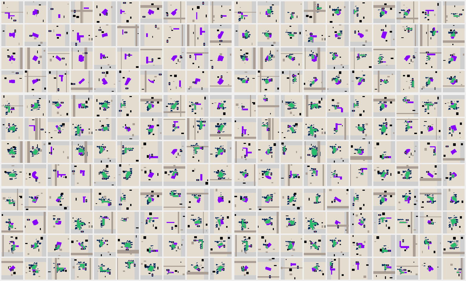
Terra comes with two types of maps: foundations and trenches. Foundations are produced by projecting real building profiles from OpenStreetMap on the grid map. Trenches are procedurally generated and are divided in three categories based on the number of axes the trench has (1 to 3). All the maps have additional layers to encode obstacles, regions where the excavator can't dump terrain (e.g. roads), and regions where the excavator needs to dump all the terrain to terminate the episode (terminal dumping areas). Check out map.py for the documentation of the map layering and logic.
We benchmark the environments by measuring the runtime of our PPO algorithm including environment steps and model update on Nvidia RTX-4090 GPUs. For all the experiments we keep constant 32 steps, 32 minibatches, and 1 update epoch.
| Scaling on single device | Scaling across devices |
|---|---|
 |
 |
We release a set of baselines and checkpoints in terra-baselines.
If you use this code in your research or project, please cite the following:
@misc{terra,
    title={Terra - Earthwork planning environment in JAX},
    author={Antonio Arbues, Lorenzo Terenzi},
    howpublished={\url{https://github.com/leggedrobotics/terra}},
    year={2024}
}
