This is additional code that we release under the GPL-3.0 license to accompany the UZH FPV dataset. It has the following main features:
- Code to read the raw Leica measurements.
- Code to assess the quality of the provided ground truth (see below for instructions):
- By matching the predicted gyro output to the actual gyro output, as proposed in this issue by Vladyslav Usenko.
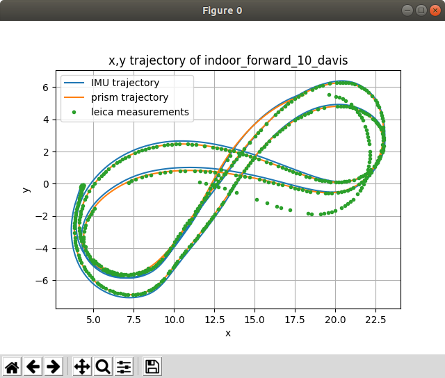
- By matching the predicted position of the prism to Leica measurements.
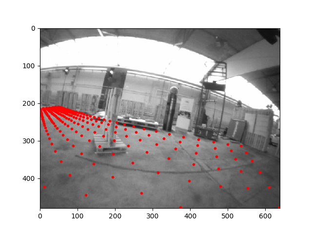
- By projecting virtual points into the camera frame to qualitatively assess the rotation estimates.
- As a serendipitous byproduct, an implementation of a time-differentiable continuous trajectory representation, see the quick tutorial.
This repository does not contain the code that was used to generate the ground truth.
Please cite the dataset paper when using the code in this repository:
@InProceedings{Delmerico19icra,
 author        = {Jeffrey Delmerico and Titus Cieslewski and Henri Rebecq and
                  Matthias Faessler and Davide Scaramuzza},
 title         = {Are We Ready for Autonomous Drone Racing? The {UZH-FPV} Drone
                  Racing Dataset},
 booktitle     = {{IEEE} Int. Conf. Robot. Autom. ({ICRA})},
 year          = 2019
}
To achieve the matching of ground truth to Leica measurements, this repository contains an implementation of a time-differentiable continuous trajectory representation based on the following publication:
@InProceedings{Mueggler15rss,
 author      = {Elias Mueggler and Guillermo Gallego and Davide Scaramuzza},
 title       = {Continuous-Time Trajectory Estimation for Event-based Vision
               Sensors},
 booktitle   = {Robotics: Science and Systems ({RSS})},
 year        = 2015,
 doi         = {10.15607/RSS.2015.XI.036}
}
It allows to solve optimization problems that include both the trajectory shape and a time offset on trajectory sampling times. For optimization, we use Casadi.
@Article{Andersson2019,
 author = {Joel A E Andersson and Joris Gillis and Greg Horn
           and James B Rawlings and Moritz Diehl},
 title = {{CasADi} -- {A} software framework for nonlinear optimization
           and optimal control},
 journal = {Mathematical Programming Computation},
 volume = {11},
 number = {1},
 pages = {1--36},
 year = {2019},
 publisher = {Springer},
 doi = {10.1007/s12532-018-0139-4}
}Assuming you have ROS Melodic installed on Ubuntu 18.04:
sudo apt install python-catkin-tools

mkdir -p uzh_fpv_ws/src
cd uzh_fpv_ws
catkin config --init --mkdirs --extend /opt/ros/melodic --merge-devel --cmake-args -DCMAKE_BUILD_TYPE=Release

cd src
git clone git@github.com:catkin/catkin_simple.git
# RPG: uzh_fpv here and below for our internal version.
git clone git@github.com:uzh-rpg/uzh_fpv_open.git
cd uzh_fpv_open
pip install -r requirements.txt

catkin build
To interact with the dataset, you will need to add the following folders to the root of the repository.
Note that you can use softlinks (ln -s /actual/location .):
| Folder | Description |
|---|---|
| calib | Contains the unzipped calibration files. |
| raw | Contains raw data: unzipped "Leica" folder from the public dataset or the raw folder from the internal dataset. |
| output | Contains the bags (not zips) from the public dataset, or the contents of v2 (or later) from the internal dataset. |
Flags defined in python/uzh_fpv/flags.py are used to specify which sequence you want to work with. For example, to use indoor_45_2_snapdragon, you would use flags --env=i --cam=45 --nr=2 --sens=snap.
Graphical output can in most scripts be suppressed with --nogui.
See the full instructions here.
python scripts/render_gt_projection.py
Rendered images are output in plots/SEQUENCE_STRING/gt_projection.
Per default, the ground truth trajectory is used for rendering. It can be replaced with an estimate according to this specification by adding a flag --estim=PATH_TO_TXT_FILE. In that case, the rendering is output to plots/SEQUENCE_STRING/es_projection.
These outputs can be converted into an mp4 video with the following command:
ffmpeg -r 30 -i %06d.png -c:v libx264 -vf fps=25 -pix_fmt yuv420p out.mp4
Found in the scripts folder. Can be categorized as follows:
make_min_imu_gto_bag.py: Create a min_bag containing only imu and ground truth, for faster processing in other scripts.
compare_gyro.py (as proposed in this issue by Vladyslav Usenko), plot_leica.py, plot_leica_vs_gt.py, match_davis_to_snapdragon_gt.py(matches davis to snapdragon groundtruth according to a provided time-offset)
batch_check_ground_truths.py, batch_degroundtruth.py (create bags and zips without ground truths, for datasets where ground truth is withheld), print_files_to_publish.py (list of files to be published, to verify contents of the public directory)
The authors would like to thank Stefan Gächter, Zoltan Török, and Thomas Mörwald of Leica Geosystems for their support in gathering our data, and Innovation Park Zürich and the Fässler family for providing experimental space. Additional thanks go to iniVation AG and Prof. Tobi Delbruck for their support and guidance with the mDAVIS sensors, and to Francisco Javier Pérez Grau for his help in the evaluation.
We would also like to thank Vladyslav Usenko from the Computer Vision Group at TU Munich and Patrick Geneva from the Robot Perception and Navigation Group at the University of Delaware for their feedback on the dataset. Finally, we would like to thank our colleague Zichao Zhang from the Robotics and Perception Group for his help in the competitions that are associated with the datasets, as well as his feedback during the development of this code.
This work was supported by the National Centre of Competence inResearch Robotics (NCCR) through the Swiss National Science Foundation,the SNSF-ERC Starting Grant, and the DARPA Fast Lightweight Autonomy Program.


